
Sortie rapide à vélo de Marienthal à Steilshoop
Personnalise ton propre itinéraire à partir de notre modèle ou découvre comment notre communauté préfère rouler de Marienthal à Steilshoop.
Modèle d’itinéraire
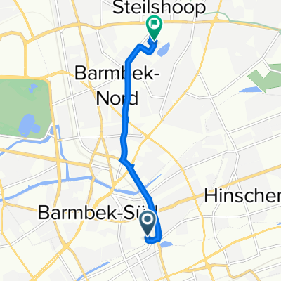
De Marienthal à Steilshoop

- 48 min
- Durée
- 11,8 km
- Distance
- 41 m
- Montée
- 24 m
- Descente
- 14,6 km/h
- Vit. moyenne
- 32 m
- Altitude max.
Set off from the leafy residential streets of Marienthal, a peaceful Hamburg neighborhood known for its historic villas and green spaces. Your route to Steilshoop covers about 12 km, winding mostly along quiet, paved roads with a gentle ascent—perfect for an easy-going ride.
Soon after starting, you’ll pass through a mix of tranquil streets and cycle-friendly paths, making this a relaxed route even for novice cyclists. The ride weaves through some of Hamburg’s lesser-known corners, so keep an eye out for local parks and allotment gardens along the way. With around 65% asphalt and more than 85% paved surfaces, you’re in for a smooth journey.
Reaching Steilshoop, you’ll find a vibrant, multicultural district famous for its distinct 1970s apartment blocks and rich community life. Steilshoop is also surrounded by plenty of green spaces—perfect for a quick breather after your ride! Overall, this route is a great way to connect two different sides of Hamburg and experience the city from a cyclist’s perspective.
Communauté
Meilleurs utilisateurs dans cette région


De notre communauté
Les meilleurs itinéraires à vélo de Marienthal à Steilshoop

Schrecklich
Itinéraire à vélo à Marienthal, Ville-État de Hambourg, Allemagne
- 21,2 km
- Distance
- 59 m
- Montée
- 60 m
- Descente

Brauhausstraße 5, Hamburg to Georg-Raloff-Ring 46, Hamburg
Itinéraire à vélo à Marienthal, Ville-État de Hambourg, Allemagne
- 4,9 km
- Distance
- 36 m
- Montée
- 35 m
- Descente

Friedenstraße nach Rahnstraße
Itinéraire à vélo à Marienthal, Ville-État de Hambourg, Allemagne
- 5,2 km
- Distance
- 18 m
- Montée
- 14 m
- Descente

Brauhausstieg 15, Hamburg nach Werner-Otto-Straße 13–15, Hamburg
Itinéraire à vélo à Marienthal, Ville-État de Hambourg, Allemagne
- 4,1 km
- Distance
- 22 m
- Montée
- 19 m
- Descente

Grete-Zabe-Weg 32, Hamburg to Georg-Raloff-Ring 46, Hamburg
Itinéraire à vélo à Marienthal, Ville-État de Hambourg, Allemagne
- 4,2 km
- Distance
- 14 m
- Montée
- 7 m
- Descente

Brauhausstieg 15, Hamburg nach Werner-Otto-Straße 13M, Hamburg
Itinéraire à vélo à Marienthal, Ville-État de Hambourg, Allemagne
- 4 km
- Distance
- 20 m
- Montée
- 14 m
- Descente

Friedrichsberg, Hamburg nach Edwin-Scharff-Ring 50, Hamburg
Itinéraire à vélo à Marienthal, Ville-État de Hambourg, Allemagne
- 5,9 km
- Distance
- 30 m
- Montée
- 14 m
- Descente

Brauhausstieg 15, Hamburg nach Werner-Otto-Straße 13–15, Hamburg
Itinéraire à vélo à Marienthal, Ville-État de Hambourg, Allemagne
- 4 km
- Distance
- 45 m
- Montée
- 33 m
- Descente

Caspar-Voght-Straße 50, Hamburg nach Berner Chaussee 49, Hamburg
Itinéraire à vélo à Marienthal, Ville-État de Hambourg, Allemagne
- 8,6 km
- Distance
- 31 m
- Montée
- 25 m
- Descente

Friedrichsberg, Hamburg nach Edwin-Scharff-Ring 52, Hamburg
Itinéraire à vélo à Marienthal, Ville-État de Hambourg, Allemagne
- 6,9 km
- Distance
- 71 m
- Montée
- 55 m
- Descente

nach hause
Itinéraire à vélo à Marienthal, Ville-État de Hambourg, Allemagne
- 6,2 km
- Distance
- 17 m
- Montée
- 12 m
- Descente

Brauhausstieg 15, Hamburg nach Werner-Otto-Straße 13, Hamburg
Itinéraire à vélo à Marienthal, Ville-État de Hambourg, Allemagne
- 4,1 km
- Distance
- 33 m
- Montée
- 27 m
- Descente
Découvrez plus d'itinéraires
 Grete-Zabe-Weg 32, Hamburg to Georg-Raloff-Ring 46, Hamburg
- Distance
- 4,2 km
- Montée
- 14 m
- Descente
- 7 m
- Emplacement
- Marienthal, Ville-État de Hambourg, Allemagne
 Brauhausstieg 15, Hamburg nach Werner-Otto-Straße 13M, Hamburg
- Distance
- 4 km
- Montée
- 20 m
- Descente
- 14 m
- Emplacement
- Marienthal, Ville-État de Hambourg, Allemagne
 Friedrichsberg, Hamburg nach Edwin-Scharff-Ring 50, Hamburg
- Distance
- 5,9 km
- Montée
- 30 m
- Descente
- 14 m
- Emplacement
- Marienthal, Ville-État de Hambourg, Allemagne
 Brauhausstieg 15, Hamburg nach Werner-Otto-Straße 13–15, Hamburg
- Distance
- 4 km
- Montée
- 45 m
- Descente
- 33 m
- Emplacement
- Marienthal, Ville-État de Hambourg, Allemagne
 Caspar-Voght-Straße 50, Hamburg nach Berner Chaussee 49, Hamburg
- Distance
- 8,6 km
- Montée
- 31 m
- Descente
- 25 m
- Emplacement
- Marienthal, Ville-État de Hambourg, Allemagne
 Friedrichsberg, Hamburg nach Edwin-Scharff-Ring 52, Hamburg
- Distance
- 6,9 km
- Montée
- 71 m
- Descente
- 55 m
- Emplacement
- Marienthal, Ville-État de Hambourg, Allemagne
 nach hause
- Distance
- 6,2 km
- Montée
- 17 m
- Descente
- 12 m
- Emplacement
- Marienthal, Ville-État de Hambourg, Allemagne
 Brauhausstieg 15, Hamburg nach Werner-Otto-Straße 13, Hamburg
- Distance
- 4,1 km
- Montée
- 33 m
- Descente
- 27 m
- Emplacement
- Marienthal, Ville-État de Hambourg, Allemagne
Itinéraires depuis Marienthal
Excursion à vélo d’une journée de
Marienthal à Reinbek
Sortie rapide à vélo de
Marienthal à Borgfelde
Sortie rapide à vélo de
Marienthal à Barmbek-Nord
Itinéraires vers Steilshoop
Sortie rapide à vélo de
Farmsen-Berne à Steilshoop