
Excursion à vélo d’une journée de Bad Schandau à Sebnitz
Personnalise ton propre itinéraire à partir de notre modèle ou découvre comment notre communauté préfère rouler de Bad Schandau à Sebnitz.
Modèle d’itinéraire
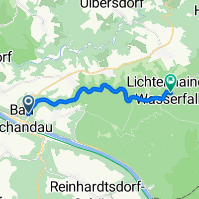
De Bad Schandau à Sebnitz

- 2 h 16 min
- Durée
- 34,7 km
- Distance
- 742 m
- Montée
- 553 m
- Descente
- 15,3 km/h
- Vit. moyenne
- 468 m
- Altitude max.
Pedal out of picturesque Bad Schandau—right on the banks of the Elbe and a gateway into Saxon Switzerland National Park—heading north toward Sebnitz. This 35 km ride is a real treat for nature lovers and offers a good workout, with about 740 meters of climbing as you roll through lush forested hills and charming villages of the Sächsische Schweiz region.
The road is mostly smooth asphalt, so it’s well-suited for road bikes, and much of the journey is on quiet, peaceful routes. Watch for glimpses of the Elbe sandstone landscapes and possible stops for scenic photos or quick refreshments in local cafés.
Arriving in Sebnitz, you’ll find a town famous for its century-old tradition of handmade silk flowers—so much so that it’s often called the “City of Silk Flowers.” Treat yourself to a stroll through its quaint town center or check out the Sebnitz Flower Factory Museum before hopping back on your bike or grabbing a coffee. All in all, this route gives you a perfect slice of Saxon countryside with a bit of climbing to keep things lively!
Communauté
Meilleurs utilisateurs dans cette région


De notre communauté
Les meilleurs itinéraires à vélo de Bad Schandau à Sebnitz

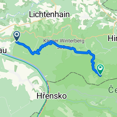
27_Großer Winterberg - Kirnitzschtal
Itinéraire à vélo à Bad Schandau, État libre de Saxe, Allemagne
- 10 km
- Distance
- 617 m
- Montée
- 550 m
- Descente

Vorschlag MBWE, 25.8.2018
Itinéraire à vélo à Bad Schandau, État libre de Saxe, Allemagne
- 16,8 km
- Distance
- 549 m
- Montée
- 569 m
- Descente

AugustusTours Rundwanderung 6: Bad Schandau - Lichtenhainer Wasserfall
Itinéraire à vélo à Bad Schandau, État libre de Saxe, Allemagne
- 13,2 km
- Distance
- 336 m
- Montée
- 263 m
- Descente

Schmilka - Winterstein - Endlerkuppe - Ottendorf
Itinéraire à vélo à Bad Schandau, État libre de Saxe, Allemagne
- 17,2 km
- Distance
- 631 m
- Montée
- 454 m
- Descente

Kirnitzschtalbahn
Itinéraire à vélo à Bad Schandau, État libre de Saxe, Allemagne
- 7,9 km
- Distance
- 164 m
- Montée
- 102 m
- Descente

Etappe 8 einmal durch Sächsische Schweiz und zurück
Itinéraire à vélo à Bad Schandau, État libre de Saxe, Allemagne
- 19,7 km
- Distance
- 263 m
- Montée
- 125 m
- Descente

Wanderung Häntzschelstiege
Itinéraire à vélo à Bad Schandau, État libre de Saxe, Allemagne
- 13,3 km
- Distance
- 564 m
- Montée
- 532 m
- Descente

Traska1
Itinéraire à vélo à Bad Schandau, État libre de Saxe, Allemagne
- 12,6 km
- Distance
- 266 m
- Montée
- 185 m
- Descente

Roter-Bus-Schrammstein
Itinéraire à vélo à Bad Schandau, État libre de Saxe, Allemagne
- 13,6 km
- Distance
- 378 m
- Montée
- 365 m
- Descente

Schmilka - Prebischtor - H'h'dorf
Itinéraire à vélo à Bad Schandau, État libre de Saxe, Allemagne
- 31,7 km
- Distance
- 1 029 m
- Montée
- 780 m
- Descente

BSch_HiHeDo
Itinéraire à vélo à Bad Schandau, État libre de Saxe, Allemagne
- 18,6 km
- Distance
- 592 m
- Montée
- 355 m
- Descente

Sächsische Schweiz
Itinéraire à vélo à Bad Schandau, État libre de Saxe, Allemagne
- 13,4 km
- Distance
- 513 m
- Montée
- 455 m
- Descente
Découvrez plus d'itinéraires
 Kirnitzschtalbahn
- Distance
- 7,9 km
- Montée
- 164 m
- Descente
- 102 m
- Emplacement
- Bad Schandau, État libre de Saxe, Allemagne
 Etappe 8 einmal durch Sächsische Schweiz und zurück
- Distance
- 19,7 km
- Montée
- 263 m
- Descente
- 125 m
- Emplacement
- Bad Schandau, État libre de Saxe, Allemagne
 Wanderung Häntzschelstiege
- Distance
- 13,3 km
- Montée
- 564 m
- Descente
- 532 m
- Emplacement
- Bad Schandau, État libre de Saxe, Allemagne
 Traska1
- Distance
- 12,6 km
- Montée
- 266 m
- Descente
- 185 m
- Emplacement
- Bad Schandau, État libre de Saxe, Allemagne
 Roter-Bus-Schrammstein
- Distance
- 13,6 km
- Montée
- 378 m
- Descente
- 365 m
- Emplacement
- Bad Schandau, État libre de Saxe, Allemagne
 Schmilka - Prebischtor - H'h'dorf
- Distance
- 31,7 km
- Montée
- 1 029 m
- Descente
- 780 m
- Emplacement
- Bad Schandau, État libre de Saxe, Allemagne
 BSch_HiHeDo
- Distance
- 18,6 km
- Montée
- 592 m
- Descente
- 355 m
- Emplacement
- Bad Schandau, État libre de Saxe, Allemagne
 Sächsische Schweiz
- Distance
- 13,4 km
- Montée
- 513 m
- Descente
- 455 m
- Emplacement
- Bad Schandau, État libre de Saxe, Allemagne
Itinéraires depuis Bad Schandau
Excursion à vélo d’une journée de
Bad Schandau à Děčín
Excursion à vélo d’une journée de
Bad Schandau à Dresde