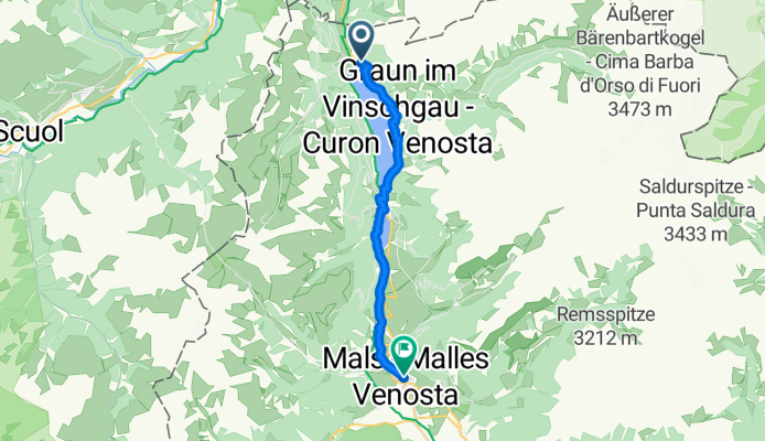
Sortie rapide à vélo de Curon Venosta à Malles Venosta
Personnalise ton propre itinéraire à partir de notre modèle ou découvre comment notre communauté préfère rouler de Curon Venosta à Malles Venosta.
Modèle d’itinéraire
De Curon Venosta à Malles Venosta

- 1 h 4 min
- Durée
- 17,8 km
- Distance
- 230 m
- Montée
- 727 m
- Descente
- 16,6 km/h
- Vit. moyenne
- 1 533 m
- Altitude max.
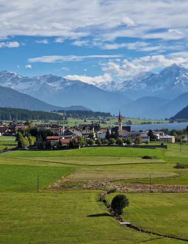
This ride kicks off in Graun im Vinschgau, famous for its hauntingly beautiful submerged bell tower rising out of Lake Reschen—a must-stop for a photo! From here, you’ll head south toward Mals, winding through 17.8 km of mostly paved roads and quiet tracks. The route serves up a good bit of descent—over 700 meters of it—so you can really enjoy cruising down through the scenic South Tyrolean landscape.
Expect breathtaking alpine views as you pass rolling fields and mountain backdrops. With most surfaces being smooth asphalt, you’ll only encounter occasional gravel patches, perfect for keeping things interesting but nothing too technical.
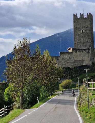
Your ride finishes in Mals, a charming town at the foot of the Ortler Alps, renowned for its Romanesque church towers and laid-back vibe. Treat yourself to a coffee or gelato at one of the local cafes—you’ve earned it! It’s a lovely ride, with just enough climb at the start to justify the sweeping descent into the heart of the Vinschgau Valley.
Tours en bikepacking
Déjà découpé en étapes parfaites par notre communauté
Communauté
Meilleurs utilisateurs dans cette région


De notre communauté
Les meilleurs itinéraires à vélo de Curon Venosta à Malles Venosta

6 Goasberg-Cross
Itinéraire à vélo à Curon Venosta, Trentin-Haut-Adige, Italie
- 17,2 km
- Distance
- 808 m
- Montée
- 1 085 m
- Descente

Obervinschger Panoramatour
Itinéraire à vélo à Curon Venosta, Trentin-Haut-Adige, Italie
- 20,8 km
- Distance
- 420 m
- Montée
- 917 m
- Descente

MTB-Tour: Obervinschgauer Panoramatour
Itinéraire à vélo à Curon Venosta, Trentin-Haut-Adige, Italie
- 22,6 km
- Distance
- 412 m
- Montée
- 842 m
- Descente

Reschen - Sesvenna Hütte
Itinéraire à vélo à Curon Venosta, Trentin-Haut-Adige, Italie
- 28,4 km
- Distance
- 1 079 m
- Montée
- 338 m
- Descente

1. Etappe nach Mals
Itinéraire à vélo à Curon Venosta, Trentin-Haut-Adige, Italie
- 19,8 km
- Distance
- 112 m
- Montée
- 552 m
- Descente

Reschen bis Quellenhof
Itinéraire à vélo à Curon Venosta, Trentin-Haut-Adige, Italie
- 21,7 km
- Distance
- 291 m
- Montée
- 717 m
- Descente

Planeil
Itinéraire à vélo à Curon Venosta, Trentin-Haut-Adige, Italie
- 23,7 km
- Distance
- 898 m
- Montée
- 1 122 m
- Descente

stelvio 1
Itinéraire à vélo à Curon Venosta, Trentin-Haut-Adige, Italie
- 84,4 km
- Distance
- 1 863 m
- Montée
- 2 423 m
- Descente

Sesvennahütte
Itinéraire à vélo à Curon Venosta, Trentin-Haut-Adige, Italie
- 25,2 km
- Distance
- 1 110 m
- Montée
- 348 m
- Descente
6 July from Reschebsee to Nalles Venosta
Itinéraire à vélo à Curon Venosta, Trentin-Haut-Adige, Italie
- 19,4 km
- Distance
- 229 m
- Montée
- 709 m
- Descente

Etappe Curon Venosta - Malles Venosta
Itinéraire à vélo à Curon Venosta, Trentin-Haut-Adige, Italie
- 16,9 km
- Distance
- 84 m
- Montée
- 557 m
- Descente

Curon Venosta a Via di Burgusio, Malles Venosta
Itinéraire à vélo à Curon Venosta, Trentin-Haut-Adige, Italie
- 18,1 km
- Distance
- 682 m
- Montée
- 981 m
- Descente
Découvrez plus d'itinéraires
 1. Etappe nach Mals
- Distance
- 19,8 km
- Montée
- 112 m
- Descente
- 552 m
- Emplacement
- Curon Venosta, Trentin-Haut-Adige, Italie
 Reschen bis Quellenhof
- Distance
- 21,7 km
- Montée
- 291 m
- Descente
- 717 m
- Emplacement
- Curon Venosta, Trentin-Haut-Adige, Italie
 Planeil
- Distance
- 23,7 km
- Montée
- 898 m
- Descente
- 1 122 m
- Emplacement
- Curon Venosta, Trentin-Haut-Adige, Italie
 stelvio 1
- Distance
- 84,4 km
- Montée
- 1 863 m
- Descente
- 2 423 m
- Emplacement
- Curon Venosta, Trentin-Haut-Adige, Italie
 Sesvennahütte
- Distance
- 25,2 km
- Montée
- 1 110 m
- Descente
- 348 m
- Emplacement
- Curon Venosta, Trentin-Haut-Adige, Italie
 6 July from Reschebsee to Nalles Venosta
- Distance
- 19,4 km
- Montée
- 229 m
- Descente
- 709 m
- Emplacement
- Curon Venosta, Trentin-Haut-Adige, Italie
 Etappe Curon Venosta - Malles Venosta
- Distance
- 16,9 km
- Montée
- 84 m
- Descente
- 557 m
- Emplacement
- Curon Venosta, Trentin-Haut-Adige, Italie
 Curon Venosta a Via di Burgusio, Malles Venosta
- Distance
- 18,1 km
- Montée
- 682 m
- Descente
- 981 m
- Emplacement
- Curon Venosta, Trentin-Haut-Adige, Italie
Itinéraires depuis Curon Venosta
Bikepacking de
Curon Venosta à Trente
Excursion à vélo d’une journée de
Curon Venosta à Merano
Excursion à vélo d’une journée de
Curon Venosta à Naturno
Itinéraires vers Malles Venosta
Bikepacking de
Landeck à Malles Venosta
Excursion à vélo d’une journée de
Scuol à Malles Venosta
Excursion à vélo d’une journée de
Nauders à Malles Venosta