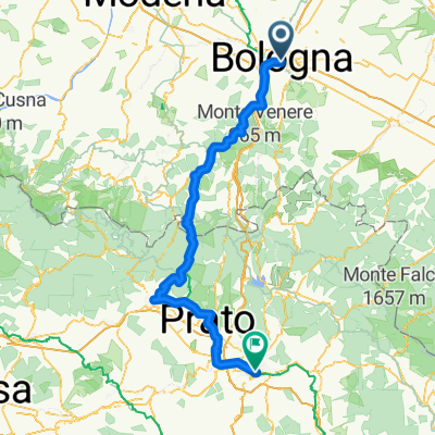

Modèle d’itinéraire
De Bologne à Florence

- 13 h 24 min
- Durée
- 157,1 km
- Distance
- 4 734 m
- Montée
- 4 758 m
- Descente
- 11,7 km/h
- Vit. moyenne
- 1 154 m
- Altitude max.
Bologna to Florence Cycle Route
Ready for an epic ride? This route takes you from the vibrant city of Bologna, famous for its medieval towers and mouthwatering pasta, all the way to the heart of Tuscany—Florence, the birthplace of the Renaissance! You’ll cover about 157 km, spending most of your time on quiet roads and cycleways threading through the stunning Apennine mountains.
Get ready for some leg-burning climbs (over 4700 meters of ascent!), but trust me, the panoramic views at over 1100 meters elevation are worth every drop of sweat. Parts of the route are smooth asphalt, while some sections might get a bit rugged—so a well-prepped bike is your best friend. Expect charming villages, tranquil forests, twisting descents, and at the finish, Florence’s famous Duomo waiting to greet you.
This isn’t a sprint, but a breathtaking adventure that connects two Italian gems. Bring snacks, take your time, and enjoy everything from pasta in Bologna to gelato in Florence!
Tours en bikepacking
Déjà découpé en étapes parfaites par notre communauté
Communauté
Meilleurs utilisateurs dans cette région
De notre communauté
Les meilleurs itinéraires à vélo de Bologne à Florence
Via Arduina '25 T03 - Bologna Firenze
Itinéraire à vélo à Bologne, Émilie-Romagne, Italie
- 124,2 km
- Distance
- 2 739 m
- Montée
- 2 731 m
- Descente
Bologna - Firenze
Itinéraire à vélo à Bologne, Émilie-Romagne, Italie
- 103,7 km
- Distance
- 1 392 m
- Montée
- 1 406 m
- Descente
Bologna - Florence
Itinéraire à vélo à Bologne, Émilie-Romagne, Italie
- 108,6 km
- Distance
- 1 364 m
- Montée
- 1 382 m
- Descente
Bologna - Firenze
Itinéraire à vélo à Bologne, Émilie-Romagne, Italie
- 106,9 km
- Distance
- 1 367 m
- Montée
- 1 371 m
- Descente
1T Intero
Itinéraire à vélo à Bologne, Émilie-Romagne, Italie
- 133 km
- Distance
- 4 870 m
- Montée
- 4 881 m
- Descente
13b Bologna Florenz östl Autobahn
Itinéraire à vélo à Bologne, Émilie-Romagne, Italie
- 110,8 km
- Distance
- 1 295 m
- Montée
- 1 319 m
- Descente
Болонья - Флоренція
Itinéraire à vélo à Bologne, Émilie-Romagne, Italie
- 121,8 km
- Distance
- 1 121 m
- Montée
- 1 143 m
- Descente
2 Bologna – Florence (UNDER_DEVELOPMENT)
Itinéraire à vélo à Bologne, Émilie-Romagne, Italie
- 167,8 km
- Distance
- 3 271 m
- Montée
- 3 280 m
- Descente
05. Bologna-Firenze
Itinéraire à vélo à Bologne, Émilie-Romagne, Italie
- 119,5 km
- Distance
- 1 342 m
- Montée
- 1 336 m
- Descente
Bologna, Parco dei Gessi, Raticosa Futa, Firenze
Itinéraire à vélo à Bologne, Émilie-Romagne, Italie
- 108,3 km
- Distance
- 1 265 m
- Montée
- 1 259 m
- Descente
Da Autostazione, Bologna a Via dei Sassetti 25, Firenze
Itinéraire à vélo à Bologne, Émilie-Romagne, Italie
- 143,1 km
- Distance
- 2 069 m
- Montée
- 2 059 m
- Descente
Bologne Florence #1
Itinéraire à vélo à Bologne, Émilie-Romagne, Italie
- 107,9 km
- Distance
- 1 359 m
- Montée
- 1 373 m
- Descente
Découvrez plus d'itinéraires
 1T Intero
- Distance
- 133 km
- Montée
- 4 870 m
- Descente
- 4 881 m
- Emplacement
- Bologne, Émilie-Romagne, Italie
 13b Bologna Florenz östl Autobahn
- Distance
- 110,8 km
- Montée
- 1 295 m
- Descente
- 1 319 m
- Emplacement
- Bologne, Émilie-Romagne, Italie
 Болонья - Флоренція
- Distance
- 121,8 km
- Montée
- 1 121 m
- Descente
- 1 143 m
- Emplacement
- Bologne, Émilie-Romagne, Italie
 2 Bologna – Florence (UNDER_DEVELOPMENT)
- Distance
- 167,8 km
- Montée
- 3 271 m
- Descente
- 3 280 m
- Emplacement
- Bologne, Émilie-Romagne, Italie
 05. Bologna-Firenze
- Distance
- 119,5 km
- Montée
- 1 342 m
- Descente
- 1 336 m
- Emplacement
- Bologne, Émilie-Romagne, Italie
 Bologna, Parco dei Gessi, Raticosa Futa, Firenze
- Distance
- 108,3 km
- Montée
- 1 265 m
- Descente
- 1 259 m
- Emplacement
- Bologne, Émilie-Romagne, Italie
 Da Autostazione, Bologna a Via dei Sassetti 25, Firenze
- Distance
- 143,1 km
- Montée
- 2 069 m
- Descente
- 2 059 m
- Emplacement
- Bologne, Émilie-Romagne, Italie
 Bologne Florence #1
- Distance
- 107,9 km
- Montée
- 1 359 m
- Descente
- 1 373 m
- Emplacement
- Bologne, Émilie-Romagne, Italie
Itinéraires depuis Bologne
Excursion à vélo d’une journée de
Bologne à Ravenne
Excursion à vélo d’une journée de
Bologne à Ferrare
À vélo de
Bologne à Ponticella
À vélo de
Bologne à San Lazzaro di Savena
Itinéraires vers Florence
Excursion à vélo d’une journée de
Arezzo à Florence
Excursion à vélo d’une journée de
Sienne à Florence
À vélo de
Fiesole à Florence
À vélo de
Scandicci à Florence


