
Excursion à vélo d’une journée de Kranjska Gora à Arnoldstein
Personnalise ton propre itinéraire à partir de notre modèle ou découvre comment notre communauté préfère rouler de Kranjska Gora à Arnoldstein.
Modèle d’itinéraire
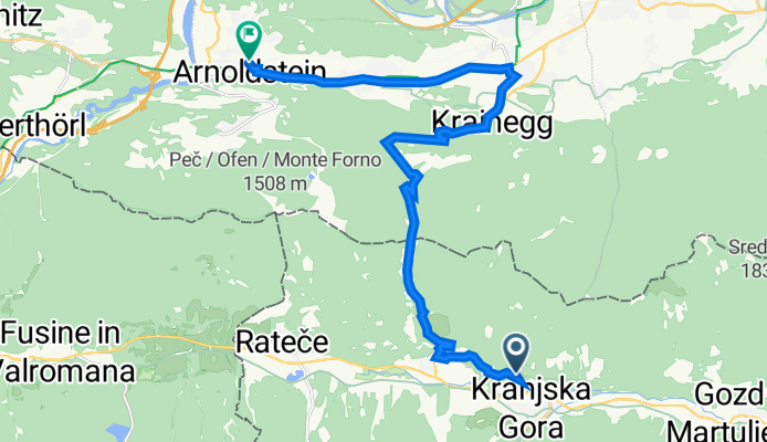
De Kranjska Gora à Arnoldstein
Get ready for a scenic ride from Kranjska Gora in Slovenia to Arnoldstein in Austria! This 35 km route packs in stunning views, historic border crossings, and has a good mix of long cycleways and quiet roads—perfect if you like a balance of comfort and adventure.
You’ll start in Kranjska Gora, a charming alpine town famous for its ski slopes (it’s also a hotspot for summer cycling and hiking). From here, you’ll pedal past emerald rivers and through mountain valleys, with a couple of climbs early on to wake up your legs (expect about 761 m of ascent, but more descent overall—so it’s mostly downhill fun into Austria).
Most of the route is paved and smooth, and you’ll be riding mostly on cycleways, so you can enjoy the scenery without stress. Arnoldstein greets you on the Austrian side, known for its old abbey and as a junction point for adventures further into Carinthia.
Don’t forget: you’re crossing a border, so have ID handy, and take a break to enjoy the epic mountain backdrop along the way!
Communauté
Meilleurs utilisateurs dans cette région
De notre communauté
Les meilleurs itinéraires à vélo de Kranjska Gora à Arnoldstein
Dreiländereck Slow. Ital.
Itinéraire à vélo à Kranjska Gora, Kranjska Gora, Slovénie
- 15,8 km
- Distance
- 735 m
- Montée
- 891 m
- Descente
Ratece - Dreiländereck
Itinéraire à vélo à Kranjska Gora, Kranjska Gora, Slovénie
- 7,2 km
- Distance
- 674 m
- Montée
- 52 m
- Descente
Planica-Rateče-Podkoren
Itinéraire à vélo à Kranjska Gora, Kranjska Gora, Slovénie
- 17,3 km
- Distance
- 1 160 m
- Montée
- 704 m
- Descente
Kr. Gora- Tromeja
Itinéraire à vélo à Kranjska Gora, Kranjska Gora, Slovénie
- 13,3 km
- Distance
- 752 m
- Montée
- 69 m
- Descente
Kranjska Gora - Arnoldstein
Itinéraire à vélo à Kranjska Gora, Kranjska Gora, Slovénie
- 18,1 km
- Distance
- 421 m
- Montée
- 678 m
- Descente
tromeja
Itinéraire à vélo à Kranjska Gora, Kranjska Gora, Slovénie
- 5,5 km
- Distance
- 699 m
- Montée
- 97 m
- Descente
TROMEJA
Itinéraire à vélo à Kranjska Gora, Kranjska Gora, Slovénie
- 7,6 km
- Distance
- 695 m
- Montée
- 54 m
- Descente
rateče-tromeja
Itinéraire à vélo à Kranjska Gora, Kranjska Gora, Slovénie
- 7,1 km
- Distance
- 736 m
- Montée
- 104 m
- Descente
Tromeja
Itinéraire à vélo à Kranjska Gora, Kranjska Gora, Slovénie
- 13 km
- Distance
- 790 m
- Montée
- 86 m
- Descente
KR.GORA-TROMEJA
Itinéraire à vélo à Kranjska Gora, Kranjska Gora, Slovénie
- 14,4 km
- Distance
- 830 m
- Montée
- 120 m
- Descente
Dreiländereck slow., ital Seite
Itinéraire à vélo à Kranjska Gora, Kranjska Gora, Slovénie
- 4,8 km
- Distance
- 365 m
- Montée
- 223 m
- Descente
rateče-tromeja
Itinéraire à vélo à Kranjska Gora, Kranjska Gora, Slovénie
- 7,1 km
- Distance
- 653 m
- Montée
- 24 m
- Descente
Découvrez plus d'itinéraires
 Kranjska Gora - Arnoldstein
- Distance
- 18,1 km
- Montée
- 421 m
- Descente
- 678 m
- Emplacement
- Kranjska Gora, Kranjska Gora, Slovénie
 tromeja
- Distance
- 5,5 km
- Montée
- 699 m
- Descente
- 97 m
- Emplacement
- Kranjska Gora, Kranjska Gora, Slovénie
 TROMEJA
- Distance
- 7,6 km
- Montée
- 695 m
- Descente
- 54 m
- Emplacement
- Kranjska Gora, Kranjska Gora, Slovénie
 rateče-tromeja
- Distance
- 7,1 km
- Montée
- 736 m
- Descente
- 104 m
- Emplacement
- Kranjska Gora, Kranjska Gora, Slovénie
 Tromeja
- Distance
- 13 km
- Montée
- 790 m
- Descente
- 86 m
- Emplacement
- Kranjska Gora, Kranjska Gora, Slovénie
 KR.GORA-TROMEJA
- Distance
- 14,4 km
- Montée
- 830 m
- Descente
- 120 m
- Emplacement
- Kranjska Gora, Kranjska Gora, Slovénie
 Dreiländereck slow., ital Seite
- Distance
- 4,8 km
- Montée
- 365 m
- Descente
- 223 m
- Emplacement
- Kranjska Gora, Kranjska Gora, Slovénie
 rateče-tromeja
- Distance
- 7,1 km
- Montée
- 653 m
- Descente
- 24 m
- Emplacement
- Kranjska Gora, Kranjska Gora, Slovénie
Itinéraires depuis Kranjska Gora
Bikepacking de
Kranjska Gora à Kobarid
Bikepacking de
Kranjska Gora à Tolmin
Excursion à vélo d’une journée de
Kranjska Gora à Tarvisio
Excursion à vélo d’une journée de
Kranjska Gora à Villach
Itinéraires vers Arnoldstein
Excursion à vélo d’une journée de
Villach à Arnoldstein


