

Excursion à vélo d’une journée de Aix-la-Chapelle à Saint-Vith
Personnalise ton propre itinéraire à partir de notre modèle ou découvre comment notre communauté préfère rouler de Aix-la-Chapelle à Saint-Vith.
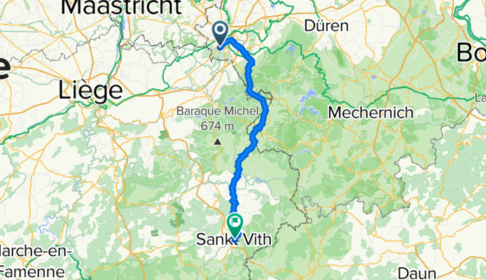
Modèle d’itinéraire
De Aix-la-Chapelle à Saint-Vith

- 4 h 36 min
- Durée
- 82,4 km
- Distance
- 847 m
- Montée
- 550 m
- Descente
- 17,9 km/h
- Vit. moyenne
- 576 m
- Altitude max.
This ride takes you from the lively German border city of Aachen down to the quiet Belgian town of Sankt Vith, covering a solid 82 km through beautiful West European countryside. Starting in Aachen—famous for its grand cathedral and student buzz—you’ll soon find yourself rolling out of the city via smooth, mostly asphalt cycleways (over half the route is on dedicated bike paths, so expect a relaxed vibe).
The route gradually ascends into the hills, with almost 850 meters of climbing—enough for a gentle workout, but nothing too daunting. The scenery shifts from urban outskirts to peaceful rural stretches and classic Ardennes woodlands. South of the border, you'll enjoy uninterrupted riding on the famed Vennbahn rail trail, a former railway converted into a top-class cycle route.
Arriving in Sankt Vith, take time to explore its picturesque old center and relaxed cafés. With virtually the whole route paved and barely a busy road in sight, this is a fantastic ride for anyone looking to explore the region by bike. Bring snacks, enjoy the views, and don’t forget your camera!
Communauté
Meilleurs utilisateurs dans cette région


De notre communauté
Les meilleurs itinéraires à vélo de Aix-la-Chapelle à Saint-Vith

Přejezd Německa 22.7. 2016
Itinéraire à vélo à Aix-la-Chapelle, Rhénanie du Nord-Westphalie, Allemagne
- 92,8 km
- Distance
- 559 m
- Montée
- 302 m
- Descente

AC-St Vith Vennb.
Itinéraire à vélo à Aix-la-Chapelle, Rhénanie du Nord-Westphalie, Allemagne
- 89,3 km
- Distance
- 557 m
- Montée
- 267 m
- Descente

Vennbahntrasse Tag 1
Itinéraire à vélo à Aix-la-Chapelle, Rhénanie du Nord-Westphalie, Allemagne
- 144,4 km
- Distance
- 728 m
- Montée
- 537 m
- Descente

Aachen Sankt Vith Vennbahn
Itinéraire à vélo à Aix-la-Chapelle, Rhénanie du Nord-Westphalie, Allemagne
- 93,9 km
- Distance
- 874 m
- Montée
- 599 m
- Descente

Aachen - Sankt Vith
Itinéraire à vélo à Aix-la-Chapelle, Rhénanie du Nord-Westphalie, Allemagne
- 91,6 km
- Distance
- 947 m
- Montée
- 638 m
- Descente

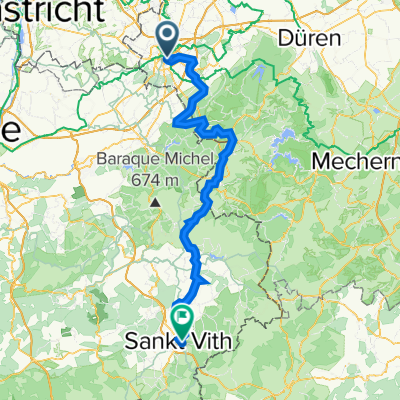
Venn Route Aachen - Sankt Vith
Itinéraire à vélo à Aix-la-Chapelle, Rhénanie du Nord-Westphalie, Allemagne
- 89,8 km
- Distance
- 794 m
- Montée
- 507 m
- Descente

Etappe 1 und 2 Aachen -Moschau - St Vith mit Malmedy
Itinéraire à vélo à Aix-la-Chapelle, Rhénanie du Nord-Westphalie, Allemagne
- 110,5 km
- Distance
- 1 097 m
- Montée
- 804 m
- Descente

Vennbahnweg: Aachen - Walheim
Itinéraire à vélo à Aix-la-Chapelle, Rhénanie du Nord-Westphalie, Allemagne
- 89,3 km
- Distance
- 597 m
- Montée
- 305 m
- Descente

Vennbahntrasse 2021
Itinéraire à vélo à Aix-la-Chapelle, Rhénanie du Nord-Westphalie, Allemagne
- 90,4 km
- Distance
- 586 m
- Montée
- 300 m
- Descente

1 - Aachen St.Vith
Itinéraire à vélo à Aix-la-Chapelle, Rhénanie du Nord-Westphalie, Allemagne
- 97 km
- Distance
- 616 m
- Montée
- 316 m
- Descente
Aachen - Sankt Vith
Itinéraire à vélo à Aix-la-Chapelle, Rhénanie du Nord-Westphalie, Allemagne
- 74 km
- Distance
- 919 m
- Montée
- 689 m
- Descente

AachenHbf-St.Vith77km880hm
Itinéraire à vélo à Aix-la-Chapelle, Rhénanie du Nord-Westphalie, Allemagne
- 76,3 km
- Distance
- 741 m
- Montée
- 445 m
- Descente
Découvrez plus d'itinéraires
 Aachen - Sankt Vith
- Distance
- 91,6 km
- Montée
- 947 m
- Descente
- 638 m
- Emplacement
- Aix-la-Chapelle, Rhénanie du Nord-Westphalie, Allemagne
 Venn Route Aachen - Sankt Vith
- Distance
- 89,8 km
- Montée
- 794 m
- Descente
- 507 m
- Emplacement
- Aix-la-Chapelle, Rhénanie du Nord-Westphalie, Allemagne
 Etappe 1 und 2 Aachen -Moschau - St Vith mit Malmedy
- Distance
- 110,5 km
- Montée
- 1 097 m
- Descente
- 804 m
- Emplacement
- Aix-la-Chapelle, Rhénanie du Nord-Westphalie, Allemagne
 Vennbahnweg: Aachen - Walheim
- Distance
- 89,3 km
- Montée
- 597 m
- Descente
- 305 m
- Emplacement
- Aix-la-Chapelle, Rhénanie du Nord-Westphalie, Allemagne
 Vennbahntrasse 2021
- Distance
- 90,4 km
- Montée
- 586 m
- Descente
- 300 m
- Emplacement
- Aix-la-Chapelle, Rhénanie du Nord-Westphalie, Allemagne
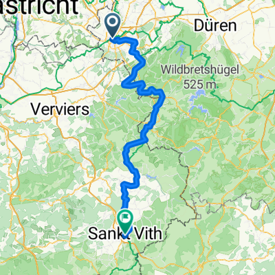 1 - Aachen St.Vith
- Distance
- 97 km
- Montée
- 616 m
- Descente
- 316 m
- Emplacement
- Aix-la-Chapelle, Rhénanie du Nord-Westphalie, Allemagne
 Aachen - Sankt Vith
- Distance
- 74 km
- Montée
- 919 m
- Descente
- 689 m
- Emplacement
- Aix-la-Chapelle, Rhénanie du Nord-Westphalie, Allemagne
 AachenHbf-St.Vith77km880hm
- Distance
- 76,3 km
- Montée
- 741 m
- Descente
- 445 m
- Emplacement
- Aix-la-Chapelle, Rhénanie du Nord-Westphalie, Allemagne
Itinéraires depuis Aix-la-Chapelle
Bikepacking de
Aix-la-Chapelle à Trèves
Excursion à vélo d’une journée de
Aix-la-Chapelle à Maastricht
Excursion à vélo d’une journée de
Aix-la-Chapelle à Roetgen
Sortie rapide à vélo de
Aix-la-Chapelle à Vaals
Sortie rapide à vélo de
Aix-la-Chapelle à Alsdorf