
À vélo de Minneapolis à Falcon Heights
Personnalise ton propre itinéraire à partir de notre modèle ou découvre comment notre communauté préfère rouler de Minneapolis à Falcon Heights.
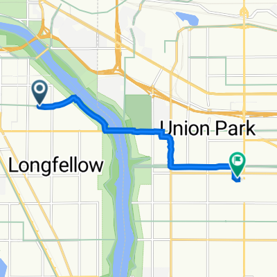
Modèle d’itinéraire
De Minneapolis à Falcon Heights
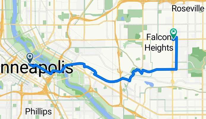
- 43 min
- Durée
- 11,9 km
- Distance
- 72 m
- Montée
- 39 m
- Descente
- 16,7 km/h
- Vit. moyenne
- 291 m
- Altitude max.
Get ready for a relaxed ride from the heart of Minneapolis out to Falcon Heights! This nearly 12-kilometer journey takes you from the vibrant Downtown—known for its skyscrapers and busy culture—through neighborhoods and parks, straight into the leafy, college-town vibes of Falcon Heights, home of the Minnesota State Fair and the University of Minnesota's St. Paul campus.
You'll spend most of your ride on smooth, paved cycleways and quiet roads—perfect for an easy cruise. There's a gentle climb as you roll northeast, with a few hills to keep things interesting but nothing too tough. As you leave behind Minneapolis' urban hustle, the scenery shifts to quiet, tree-lined streets, and you'll catch glimpses of the Minnesota State Fairgrounds as you near your destination.
It’s a great route for casual cyclists, commuters, or anyone who just wants a change of pace. Don’t forget to stop for a coffee or a snack at one of the neighborhood cafés along the way!
Communauté
Meilleurs utilisateurs dans cette région


De notre communauté
Les meilleurs itinéraires à vélo de Minneapolis à Falcon Heights
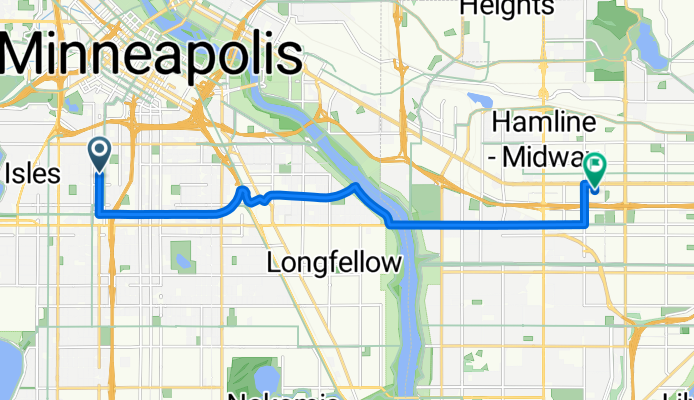
B2B00212 55404>55104 viaMidtownGreenway/wRiver/LakeSt.Marshall/Hamline
Itinéraire à vélo à Minneapolis, Minnesota, États Unis
- 12,4 km
- Distance
- 47 m
- Montée
- 35 m
- Descente

B2B00302 55405>55108 via Greenway, Raymond Ave
Itinéraire à vélo à Minneapolis, Minnesota, États Unis
- 15,3 km
- Distance
- 45 m
- Montée
- 40 m
- Descente

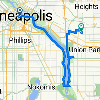
B2B00160 55407>55108 via 32nd, marshall, otis, pelham, and hewitt
Itinéraire à vélo à Minneapolis, Minnesota, États Unis
- 11 km
- Distance
- 97 m
- Montée
- 76 m
- Descente

B2B00551 55405>55108 via Park Av, University Av, Como Av
Itinéraire à vélo à Minneapolis, Minnesota, États Unis
- 15,6 km
- Distance
- 94 m
- Montée
- 79 m
- Descente

B2B00905 55411>55108 via Plymouth Av, University Av, Transitway
Itinéraire à vélo à Minneapolis, Minnesota, États Unis
- 13,4 km
- Distance
- 105 m
- Montée
- 75 m
- Descente

B2B00571 55404 < 55114 via Pleasant, Greenway, River Rd, Phelam
Itinéraire à vélo à Minneapolis, Minnesota, États Unis
- 10,9 km
- Distance
- 41 m
- Montée
- 36 m
- Descente

B2B00527 55409>55108 via Park Av, University Av, Transitway
Itinéraire à vélo à Minneapolis, Minnesota, États Unis
- 15 km
- Distance
- 94 m
- Montée
- 58 m
- Descente

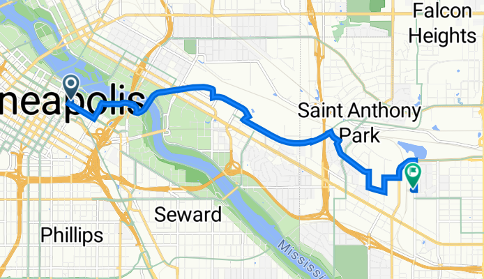
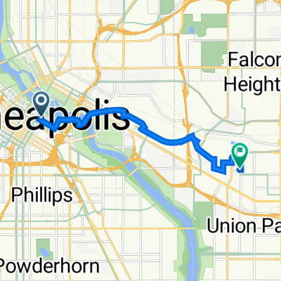
B2B00369 55401 > 55108 via Stonearch, University, Transitway, Energy Park Dr
Itinéraire à vélo à Minneapolis, Minnesota, États Unis
- 11,2 km
- Distance
- 76 m
- Montée
- 45 m
- Descente

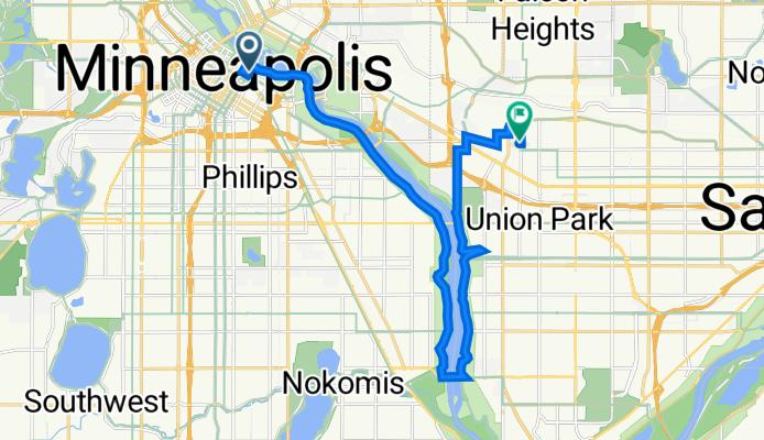
B2B00645 55406 > 55114 via Franklin Ave, University Ave
Itinéraire à vélo à Minneapolis, Minnesota, États Unis
- 2,6 km
- Distance
- 51 m
- Montée
- 33 m
- Descente
Vestibule shop best route
Itinéraire à vélo à Minneapolis, Minnesota, États Unis
- 19,1 km
- Distance
- 217 m
- Montée
- 196 m
- Descente
205 Park Ave, Minneapolis to 755 Prior Ave N, Saint Paul
Itinéraire à vélo à Minneapolis, Minnesota, États Unis
- 8,9 km
- Distance
- 61 m
- Montée
- 41 m
- Descente
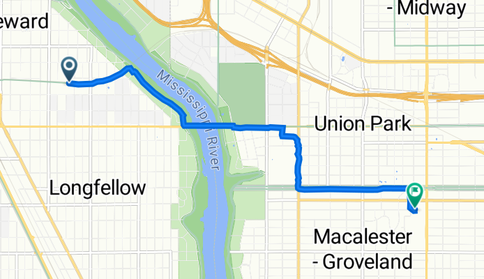
Longfellow, Minneapolis to 90 Macalester St, Saint Paul
Itinéraire à vélo à Minneapolis, Minnesota, États Unis
- 5,9 km
- Distance
- 177 m
- Montée
- 145 m
- Descente
Découvrez plus d'itinéraires
 B2B00905 55411>55108 via Plymouth Av, University Av, Transitway
- Distance
- 13,4 km
- Montée
- 105 m
- Descente
- 75 m
- Emplacement
- Minneapolis, Minnesota, États Unis
 B2B00571 55404 < 55114 via Pleasant, Greenway, River Rd, Phelam
- Distance
- 10,9 km
- Montée
- 41 m
- Descente
- 36 m
- Emplacement
- Minneapolis, Minnesota, États Unis
 B2B00527 55409>55108 via Park Av, University Av, Transitway
- Distance
- 15 km
- Montée
- 94 m
- Descente
- 58 m
- Emplacement
- Minneapolis, Minnesota, États Unis
 B2B00369 55401 > 55108 via Stonearch, University, Transitway, Energy Park Dr
- Distance
- 11,2 km
- Montée
- 76 m
- Descente
- 45 m
- Emplacement
- Minneapolis, Minnesota, États Unis
 B2B00645 55406 > 55114 via Franklin Ave, University Ave
- Distance
- 2,6 km
- Montée
- 51 m
- Descente
- 33 m
- Emplacement
- Minneapolis, Minnesota, États Unis
 Vestibule shop best route
- Distance
- 19,1 km
- Montée
- 217 m
- Descente
- 196 m
- Emplacement
- Minneapolis, Minnesota, États Unis
 205 Park Ave, Minneapolis to 755 Prior Ave N, Saint Paul
- Distance
- 8,9 km
- Montée
- 61 m
- Descente
- 41 m
- Emplacement
- Minneapolis, Minnesota, États Unis
 Longfellow, Minneapolis to 90 Macalester St, Saint Paul
- Distance
- 5,9 km
- Montée
- 177 m
- Descente
- 145 m
- Emplacement
- Minneapolis, Minnesota, États Unis
Itinéraires depuis Minneapolis
Excursion à vélo d’une journée de
Minneapolis à Mendota Heights
Excursion à vélo d’une journée de
Minneapolis à Saint Paul
À vélo de
Minneapolis à Lauderdale
À vélo de
Minneapolis à Saint Louis Park