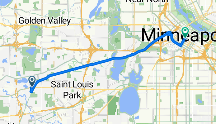

Sortie rapide à vélo de Saint Louis Park à Minneapolis
Personnalise ton propre itinéraire à partir de notre modèle ou découvre comment notre communauté préfère rouler de Saint Louis Park à Minneapolis.
Modèle d’itinéraire
De Saint Louis Park à Minneapolis
Hop on your bike in Saint Louis Park and cruise east into the heart of Minneapolis—this ride is a city classic! You’ll cover a little over 13 km, mostly on friendly cycleways and smooth pavement, so it’s ideal for a relaxing commute or a mellow weekend spin. The route has a gentle climb at the start, but you’ll lose a bit more elevation than you gain—perfect for keeping the legs fresh as you roll into town.
Saint Louis Park is known for its leafy neighborhoods and wide-open parks, while Minneapolis is packed with bike-friendly infrastructure, coffee shops, and a thriving riverfront. With more than 80% of the ride on paved surfaces and most of it set aside for bikes, you’ll enjoy stress-free pedaling. Don’t forget to look up as you cross into Minneapolis—the city’s skyline greets you as you approach, and the bike culture here is among the best in the U.S. Lock up your bike at one of the many racks downtown and reward yourself with a coffee or pastry before heading back!
Communauté
Meilleurs utilisateurs dans cette région
De notre communauté
Les meilleurs itinéraires à vélo de Saint Louis Park à Minneapolis
Cedar Lake Trail, St. Louis Park to 1406 Spruce Pl, Minneapolis
Itinéraire à vélo à Saint Louis Park, Minnesota, États Unis
- 25,5 km
- Distance
- 110 m
- Montée
- 126 m
- Descente
B2B00532 55426>55402 via Cedar Lake Trl, 10th St
Itinéraire à vélo à Saint Louis Park, Minnesota, États Unis
- 11,9 km
- Distance
- 61 m
- Montée
- 55 m
- Descente
B2B00705 55416 > 55402 via Midtown Greenway, Park Ave
Itinéraire à vélo à Saint Louis Park, Minnesota, États Unis
- 7,6 km
- Distance
- 17 m
- Montée
- 19 m
- Descente
B2B00876 55416>55415 via Cedar Lake Trl
Itinéraire à vélo à Saint Louis Park, Minnesota, États Unis
- 9,8 km
- Distance
- 54 m
- Montée
- 53 m
- Descente
B2B00450 55416>55402 via W 26th St, Cedar Lake Trl, S 10th St, 3rd Ave S
Itinéraire à vélo à Saint Louis Park, Minnesota, États Unis
- 9,9 km
- Distance
- 145 m
- Montée
- 149 m
- Descente
B2B00730 55416 > 55415 via Kenilworth Trail, Cedar Lake Trail
Itinéraire à vélo à Saint Louis Park, Minnesota, États Unis
- 10,7 km
- Distance
- 46 m
- Montée
- 69 m
- Descente
MidTown Greenway Run
Itinéraire à vélo à Saint Louis Park, Minnesota, États Unis
- 20,3 km
- Distance
- 95 m
- Montée
- 95 m
- Descente
B2B00008 55408>55402 via Bryant Ave, Nicollet Mall
Itinéraire à vélo à Saint Louis Park, Minnesota, États Unis
- 5,7 km
- Distance
- 17 m
- Montée
- 16 m
- Descente
B2B00259 55410>55415 via Lake Harriet Trail, Midtown Greenway, 11th Ave
Itinéraire à vélo à Saint Louis Park, Minnesota, États Unis
- 11,8 km
- Distance
- 45 m
- Montée
- 58 m
- Descente
B2B00973 55408>55455 via midtown greenway, W river road, E river road, and harvard st se
Itinéraire à vélo à Saint Louis Park, Minnesota, États Unis
- 11 km
- Distance
- 0 m
- Montée
- 27 m
- Descente
B2B00803 55410 > 55407 via E Calhoun Pkwy, Midtown Greenway
Itinéraire à vélo à Saint Louis Park, Minnesota, États Unis
- 7,7 km
- Distance
- 13 m
- Montée
- 15 m
- Descente
B2B00023 55426 > 55403 via Kenilworth and Kenwood area
Itinéraire à vélo à Saint Louis Park, Minnesota, États Unis
- 10,3 km
- Distance
- 58 m
- Montée
- 65 m
- Descente
Découvrez plus d'itinéraires
 B2B00450 55416>55402 via W 26th St, Cedar Lake Trl, S 10th St, 3rd Ave S
- Distance
- 9,9 km
- Montée
- 145 m
- Descente
- 149 m
- Emplacement
- Saint Louis Park, Minnesota, États Unis
 B2B00730 55416 > 55415 via Kenilworth Trail, Cedar Lake Trail
- Distance
- 10,7 km
- Montée
- 46 m
- Descente
- 69 m
- Emplacement
- Saint Louis Park, Minnesota, États Unis
 MidTown Greenway Run
- Distance
- 20,3 km
- Montée
- 95 m
- Descente
- 95 m
- Emplacement
- Saint Louis Park, Minnesota, États Unis
 B2B00008 55408>55402 via Bryant Ave, Nicollet Mall
- Distance
- 5,7 km
- Montée
- 17 m
- Descente
- 16 m
- Emplacement
- Saint Louis Park, Minnesota, États Unis
 B2B00259 55410>55415 via Lake Harriet Trail, Midtown Greenway, 11th Ave
- Distance
- 11,8 km
- Montée
- 45 m
- Descente
- 58 m
- Emplacement
- Saint Louis Park, Minnesota, États Unis
 B2B00973 55408>55455 via midtown greenway, W river road, E river road, and harvard st se
- Distance
- 11 km
- Montée
- 0 m
- Descente
- 27 m
- Emplacement
- Saint Louis Park, Minnesota, États Unis
 B2B00803 55410 > 55407 via E Calhoun Pkwy, Midtown Greenway
- Distance
- 7,7 km
- Montée
- 13 m
- Descente
- 15 m
- Emplacement
- Saint Louis Park, Minnesota, États Unis
 B2B00023 55426 > 55403 via Kenilworth and Kenwood area
- Distance
- 10,3 km
- Montée
- 58 m
- Descente
- 65 m
- Emplacement
- Saint Louis Park, Minnesota, États Unis
Itinéraires depuis Saint Louis Park
Excursion à vélo d’une journée de
Saint Louis Park à Burnsville
Itinéraires vers Minneapolis
Excursion à vélo d’une journée de
West Saint Paul à Minneapolis
Excursion à vélo d’une journée de
Mendota Heights à Minneapolis
Sortie rapide à vélo de
Falcon Heights à Minneapolis
Sortie rapide à vélo de
Saint Anthony à Minneapolis


