
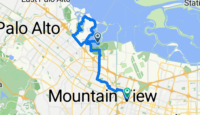


1035 Alma St, Palo Alto to 1250 Shorebird Way, Mountain View
- 10,3 km
- 7 m
- 17 m
- Palo Alto, Californie, États Unis

Personnalise ton propre itinéraire à partir de notre modèle ou découvre comment notre communauté préfère rouler de Palo Alto à Mountain View.
Modèle d’itinéraire

This ride takes you from the charming techy streets of Palo Alto to the heart of Mountain View—a breezy 11.5 km spin (just over 7 miles) that’s perfect for a quick, relaxing outing. Starting in Palo Alto, home to Stanford University and countless startup legends, you’ll cruise mostly on quiet roads, making it a chill ride and great for thinking up your own next big idea.
You’ll glide south past tree-lined neighborhoods and through spots dotted with cozy cafés, enjoying smooth asphalt most of the way. The route’s nearly flat (just a tiny climb of around 30 meters), so it’s easy on the legs. If you’re a fan of green spaces, keep an eye out for the many parks as you pass.
Roll into Mountain View—home to Google HQ and the shorelines of the Bay—and grab a bite on Castro Street or chill at Shoreline Park. Whether you’re commuting or just cruising, this ride is all about easy exploration between two Silicon Valley icons.
Communauté
De notre communauté


Itinéraire à vélo à Palo Alto, Californie, États Unis

Itinéraire à vélo à Palo Alto, Californie, États Unis
Itinéraire à vélo à Palo Alto, Californie, États Unis
Itinéraire à vélo à Palo Alto, Californie, États Unis
Itinéraire à vélo à Palo Alto, Californie, États Unis
Itinéraire à vélo à Palo Alto, Californie, États Unis
Itinéraire à vélo à Palo Alto, Californie, États Unis
Itinéraire à vélo à Palo Alto, Californie, États Unis
Itinéraire à vélo à Palo Alto, Californie, États Unis
Itinéraire à vélo à Palo Alto, Californie, États Unis
Itinéraire à vélo à Palo Alto, Californie, États Unis


