

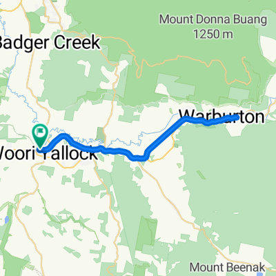
Woori Yallock - Mt Donna Buang Loop
Un itinéraire vélo au départ de Woori Yallock, Victoria, Australie.
Vue d'ensemble
À propos du circuit
Woori Yallock Bakery to summit of Mt Donna Buang avoiding the busy Warburton Hwy by using quieter back roads.
Up via Don Valley, Settlement Road and the Old Warburton Road pass (Mt Bride).
Go out of town up Riverside Drive before returning via the highway to Climb Mt Donna Buang.
Climb
Descend
Coffee stop in Warburton following the descent.
Take the highway home at first (Be warned there is no sealed shoulder, and a big drop-off at the edge of the asphalt onto the minimal gravel shoulder.)
OPTION FOR CLIMBERS: Return via Mt Bride Old warburton RoadPass
Turn south off the highway at Wesburn onto Railway Road.
Take Left at Lowes Rd
LEft onto Highway for short section.
Right onto Riversdale Road.
Turn right and Cross Yarra Junction - Noojee Rd then left into Milners Road
Climbover a spur before turning Right toward the highway on Launching Place and /Wickhams Rds.
Cross the highway and continue on Allsops Rd and then returning to the start point at the Bakery on Koo Wee Rup Rd Launching Place.
- -:--
- Durée
- 88,7 km
- Distance
- 1 640 m
- Montée
- 1 646 m
- Descente
- ---
- Vit. moyenne
- ---
- Altitude max.

Qualité de l’itinéraire
Types de voies et surfaces le long de l’itinéraire
Types de routes
Route
27,5 km
(31 %)
Route tranquille
8 km
(9 %)
surfaces
Pavé
78,1 km
(88 %)
Non pavé
6,2 km
(7 %)
Asphalte
50,6 km
(57 %)
Pavé (non défini)
27,5 km
(31 %)
Points forts de l’itinéraire
Points d’intérêt le long de l’itinéraire
Point d'intérêt après 66,6 km
Coffee stop
Continuer avec Bikemap
Utilise, modifie ou télécharge cet itinéraire vélo
Tu veux parcourir Woori Yallock - Mt Donna Buang Loop ou l’adapter à ton propre voyage ? Voici ce que tu peux faire avec cet itinéraire Bikemap :
Fonctionnalités gratuites
- Enregistre cet itinéraire comme favori ou dans une collection
- Copie et planifie ta propre version de cet itinéraire
- Divise-le en étapes pour créer un tour sur plusieurs jours
- Synchronise ton itinéraire avec Garmin ou Wahoo
Fonctionnalités Premium
Essai gratuit de 3 jours, ou paiement unique. En savoir plus sur Bikemap Premium.
- Navigue sur cet itinéraire sur iOS et Android
- Exporter un fichier GPX / KML de cet itinéraire
- Crée ton impression personnalisée (essaie-la gratuitement)
- Télécharge cet itinéraire pour la navigation hors ligne
Découvre plus de fonctionnalités Premium.
Obtiens Bikemap PremiumDe notre communauté
Woori Yallock : Autres itinéraires populaires qui commencent ici
 Warburton Rail Trail
- Distance
- 36,4 km
- Montée
- 119 m
- Descente
- 118 m
- Emplacement
- Woori Yallock, Victoria, Australie
 3 peaks training
- Distance
- 156,5 km
- Montée
- 3 113 m
- Descente
- 3 083 m
- Emplacement
- Woori Yallock, Victoria, Australie
 Yarra Valley Loop
- Distance
- 88 km
- Montée
- 903 m
- Descente
- 903 m
- Emplacement
- Woori Yallock, Victoria, Australie
 1385A Healesville-Koo Wee Rup Road, Woori Yallock to 3394 Warburton Highway, Warburton
- Distance
- 16,7 km
- Montée
- 115 m
- Descente
- 78 m
- Emplacement
- Woori Yallock, Victoria, Australie
 Piggery Hill
- Distance
- 1,2 km
- Montée
- 69 m
- Descente
- 6 m
- Emplacement
- Woori Yallock, Victoria, Australie
 Warburton Rail Trail, Launching Place to 3426 Warburton Highway, Warburton
- Distance
- 16,1 km
- Montée
- 265 m
- Descente
- 172 m
- Emplacement
- Woori Yallock, Victoria, Australie
 Warby Trail: Woori Yallock to Yarra Junction
- Distance
- 8,4 km
- Montée
- 76 m
- Descente
- 49 m
- Emplacement
- Woori Yallock, Victoria, Australie
 Woori Yallock to Warbuton
- Distance
- 17,1 km
- Montée
- 139 m
- Descente
- 73 m
- Emplacement
- Woori Yallock, Victoria, Australie
Ouvre-la dans l’app