

Taça Conservas de Matosinhos
Un itinéraire vélo au départ de Matosinhos, Porto, Portugal.
Vue d'ensemble
À propos du circuit
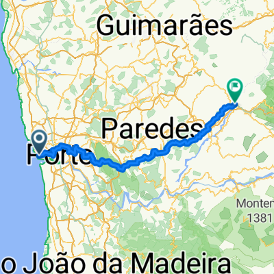
La course commence et se termine sur la plage bondée de Matosinhos, près de certaines des plus connues conserveries de poisson de la région, et se dirige vers le nord jusqu'à Vila do Conde.
Environ 30 km de routes côtières qui seront une bonne occasion pour que des BAs se forment puisque les vents atlantiques soufflent directement sur les visages des coureurs.
Après avoir atteint Vila do Conde, les coureurs tournent vers l'intérieur des terres en direction de Trofa. De là, ils commencent à courir vers le sud en passant par le petit Monte Santo Oviedo, Maia, Ermesinde, Rio Tinto et descendent vers Gondomar près du Rio Douro. Cela sera la partie la plus accidentée du parcours, mais les pentes sont si faibles et avec encore 30 km à parcourir, il sera difficile pour les puncheurs de faire des surprises.
La course entre maintenant dans sa dernière partie. Pour éviter le centre-ville bondé de Porto, les coureurs traversent São Mamede de Infesta, Leça do Balio, Santa Cruz do Bispo et Guifões. Étant les banlieues d'une grande ville, les routes ne sont pas larges et n'ont pas de virages faciles, ce qui rendra le positionnement très difficile.
Après Guifões, sur les 7 derniers km, les coureurs redescendent vers Matosinhos. Les organisateurs ont fait de leur mieux pour passer à côté de tous les principaux lieux d'intérêt de la ville (principalement les conserveries de poisson) et ont ainsi rendu la dernière partie très compliquée. Sur les 3 derniers km, nous avons 11 virages à 90° et 1 rond-point. Le dernier de ces virages se trouve à seulement 200 mètres de la ligne d'arrivée... euh, désolé, de la ligne d'arrivée.
Le positionnement et une bonne technique seront vitaux pour gagner la course.
- -:--
- Durée
- 124,4 km
- Distance
- 1 441 m
- Montée
- 1 433 m
- Descente
- ---
- Vit. moyenne
- 176 m
- Altitude max.

Qualité de l’itinéraire
Types de voies et surfaces le long de l’itinéraire
Types de routes
Route tranquille
46 km
(37 %)
Route
27,4 km
(22 %)
surfaces
Pavé
59,7 km
(48 %)
Non pavé
1,2 km
(1 %)
Asphalte
56 km
(45 %)
Pavé (non défini)
1,2 km
(1 %)
Continuer avec Bikemap
Utilise, modifie ou télécharge cet itinéraire vélo
Tu veux parcourir Taça Conservas de Matosinhos ou l’adapter à ton propre voyage ? Voici ce que tu peux faire avec cet itinéraire Bikemap :
Fonctionnalités gratuites
- Enregistre cet itinéraire comme favori ou dans une collection
- Copie et planifie ta propre version de cet itinéraire
- Divise-le en étapes pour créer un tour sur plusieurs jours
- Synchronise ton itinéraire avec Garmin ou Wahoo
Fonctionnalités Premium
Essai gratuit de 3 jours, ou paiement unique. En savoir plus sur Bikemap Premium.
- Navigue sur cet itinéraire sur iOS et Android
- Exporter un fichier GPX / KML de cet itinéraire
- Crée ton impression personnalisée (essaie-la gratuitement)
- Télécharge cet itinéraire pour la navigation hors ligne
Découvre plus de fonctionnalités Premium.
Obtiens Bikemap PremiumDe notre communauté
Matosinhos : Autres itinéraires populaires qui commencent ici
 Sprint: Matosinhos, Av Brasil, Pasteleira. Parque Cidade
- Distance
- 12,2 km
- Montée
- 124 m
- Descente
- 125 m
- Emplacement
- Matosinhos, Porto, Portugal
 Camino Português - Day 2: Rua do Godinho, Matosinhos to Rua do Lidador, Vila do Conde
- Distance
- 25,4 km
- Montée
- 182 m
- Descente
- 186 m
- Emplacement
- Matosinhos, Porto, Portugal
 Teste Altitude
- Distance
- 4,5 km
- Montée
- 89 m
- Descente
- 26 m
- Emplacement
- Matosinhos, Porto, Portugal
 Porto to Kiev
- Distance
- 3 922,2 km
- Montée
- 3 528 m
- Descente
- 3 359 m
- Emplacement
- Matosinhos, Porto, Portugal
 Camino_Coastal1
- Distance
- 27,7 km
- Montée
- 143 m
- Descente
- 168 m
- Emplacement
- Matosinhos, Porto, Portugal
 De Rua de Santa Luzia 58, Matosinhos a Rua de Santa Luzia 58, Matosinhos
- Distance
- 15,8 km
- Montée
- 52 m
- Descente
- 97 m
- Emplacement
- Matosinhos, Porto, Portugal
 Route from Porto
- Distance
- 86,2 km
- Montée
- 2 482 m
- Descente
- 2 419 m
- Emplacement
- Matosinhos, Porto, Portugal
 Volta a Portugal (Etapa 10)
- Distance
- 33 km
- Montée
- 412 m
- Descente
- 309 m
- Emplacement
- Matosinhos, Porto, Portugal
Ouvre-la dans l’app