Сarpathian peaks. Route 2.
Un itinéraire vélo au départ de Tatariv, Oblast d'Ivano-Frankivsk, Ukraine.
Vue d'ensemble
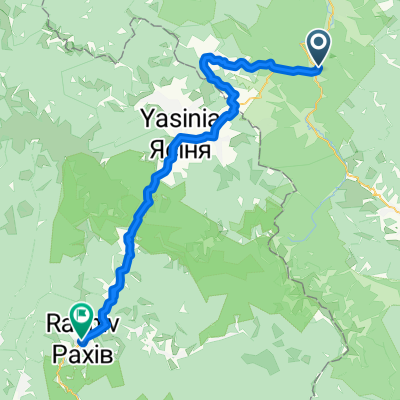
À propos du circuit
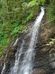
· Cascade Huk. Presque chaque troisième cascade dans les Carpates s'appelle Huk (ce qui peut se traduire par "fort"). Appelons donc celle-ci située à plusieurs kilomètres de Mykulychyn Huk Zhenetskyi, car cette cascade turbulente de 15 m de haut est située sur la rivière Zhenets.
· Pont ferroviaire en arc (viaduc). L'un des plus anciens et des plus longs ponts en pierre à arc d'Europe se trouve à Vorokhta (130 m) et la longueur d’un de ses arcs est de 65 m. Ce célèbre pont ferroviaire a été construit en 1894 et a fonctionné jusqu’en 2000. Il y a aussi l’une des plus anciennes églises en bois du XVIIe siècle – l’église de la Nativité de la Vierge, préservée à Vorokhta.
· Col de Yablunytskyi (col Tatarsky) – 931 m au-dessus du niveau de la mer. Ici, vous visiterez le marché de souvenirs connu non seulement dans les Carpates mais dans toute l’Ukraine. À Tatariv, nous nous arrêterons au monument de la période de la Première Guerre mondiale.
- -:--
- Durée
- 60,1 km
- Distance
- 621 m
- Montée
- 621 m
- Descente
- ---
- Vit. moyenne
- ---
- Altitude max.
Points forts de l’itinéraire
Points d’intérêt le long de l’itinéraire

Point d'intérêt après 10,4 km
Waterfall Huk (may be translated as “loud”) is turbulent 15m-high waterfall situated on the Zhenets river at an altitude 900 m above sea level. Due to constant moisture and breezes from waterfall, vegetation here is very diverse.

Point d'intérêt après 24,6 km
• Railway arched bridge (viaduct). One of the oldest and the longest stone arched bridges of Europe is situated in Vorokhta (130 m) and the length of one of the arches is 65 m. This famous railway bridge was built in 1894 and operated till 2000.

Point d'intérêt après 37,5 km
Yablonitsky Pass is a pass through the Carpathian Mountains in Ukraine, located in the south-eastern part of Ivano-Frankivsk Oblast. It is one of several passes connecting Transcarpathia with the rest of the country. The headwaters of the Prut River are in the northern end of this pass, and its southern end is part of the Tisza River valley. Here you can visit the souvenir market known not only in the Carpathians but in the whole Ukraine.
Continuer avec Bikemap
Utilise, modifie ou télécharge cet itinéraire vélo
Tu veux parcourir Сarpathian peaks. Route 2. ou l’adapter à ton propre voyage ? Voici ce que tu peux faire avec cet itinéraire Bikemap :
Fonctionnalités gratuites
- Enregistre cet itinéraire comme favori ou dans une collection
- Copie et planifie ta propre version de cet itinéraire
- Synchronise ton itinéraire avec Garmin ou Wahoo
Fonctionnalités Premium
Essai gratuit de 3 jours, ou paiement unique. En savoir plus sur Bikemap Premium.
- Navigue sur cet itinéraire sur iOS et Android
- Exporter un fichier GPX / KML de cet itinéraire
- Crée ton impression personnalisée (essaie-la gratuitement)
- Télécharge cet itinéraire pour la navigation hors ligne
Découvre plus de fonctionnalités Premium.
Obtiens Bikemap PremiumDe notre communauté
Tatariv : Autres itinéraires populaires qui commencent ici
 Mykulychyn- Yaremcha
- Distance
- 64 km
- Montée
- 1 522 m
- Descente
- 1 571 m
- Emplacement
- Tatariv, Oblast d'Ivano-Frankivsk, Ukraine
 Татарів - Буковель - Бистриця - Надвірна
- Distance
- 74,3 km
- Montée
- 1 339 m
- Descente
- 1 590 m
- Emplacement
- Tatariv, Oblast d'Ivano-Frankivsk, Ukraine
 Carpathian Peaks. Route 1.
- Distance
- 26,4 km
- Montée
- 368 m
- Descente
- 369 m
- Emplacement
- Tatariv, Oblast d'Ivano-Frankivsk, Ukraine
 Сarpathian peaks. Route 2.
- Distance
- 60,1 km
- Montée
- 621 m
- Descente
- 621 m
- Emplacement
- Tatariv, Oblast d'Ivano-Frankivsk, Ukraine
 Carpathian peaks. Mt.Lisniv - Mykulychyn
- Distance
- 41,7 km
- Montée
- 855 m
- Descente
- 1 501 m
- Emplacement
- Tatariv, Oblast d'Ivano-Frankivsk, Ukraine
 Татарів - Микуличин - Космач - Шепіт - Білоберізка
- Distance
- 86,2 km
- Montée
- 1 640 m
- Descente
- 1 869 m
- Emplacement
- Tatariv, Oblast d'Ivano-Frankivsk, Ukraine
 Татарів-Буковель-Рахів
- Distance
- 68,5 km
- Montée
- 508 m
- Descente
- 749 m
- Emplacement
- Tatariv, Oblast d'Ivano-Frankivsk, Ukraine
 Khomiak by bike
- Distance
- 38,6 km
- Montée
- 1 778 m
- Descente
- 1 944 m
- Emplacement
- Tatariv, Oblast d'Ivano-Frankivsk, Ukraine
Ouvre-la dans l’app


