

CYCLING THE RHINE: Route 12A
Un itinéraire vélo au départ de Coblence, Rhénanie-Palatinat, Allemagne.
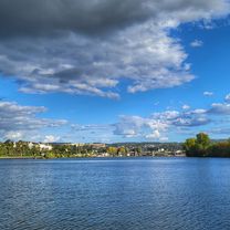
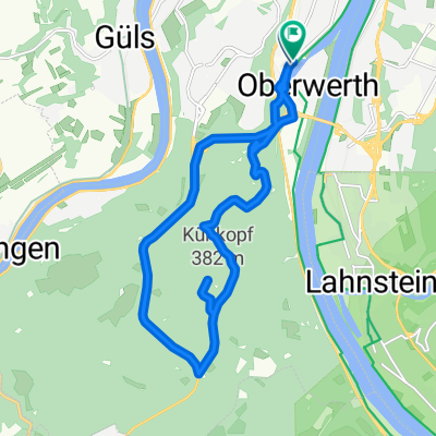
Vue d'ensemble
À propos du circuit
De la gare de Koblenz à la gare de Bacharach, en suivant le fleuve Rhin. Veuillez noter que le profil montre incorrectement certains points hauts qui n'existent pas, notamment autour des marques de 5 km et 40 km.
- -:--
- Durée
- 49,7 km
- Distance
- 179 m
- Montée
- 152 m
- Descente
- ---
- Vit. moyenne
- ---
- Altitude max.
Qualité de l’itinéraire
Types de voies et surfaces le long de l’itinéraire
Types de routes
Sentier
22,4 km
(45 %)
Route d'accès
7 km
(14 %)
surfaces
Pavé
34,3 km
(69 %)
Non pavé
1 km
(2 %)
Asphalte
29,3 km
(59 %)
Pavé (non défini)
3 km
(6 %)
Points forts de l’itinéraire
Points d’intérêt le long de l’itinéraire
Hébergement après 0,8 km
I have camped here and found the facilities to be excellent. The sounds of the passing river traffic is magical.
Hébergement après 0,8 km
YOUTH HOSTEL: DJH Ehrenbreitstein This Youth Hostel is in the Ehrenbreitstein fortress, the second largest fortress in Europe.
Point d'intérêt après 6,4 km
Ferry
Hébergement après 8,7 km
Hotel Restaurant Roter Ochse, Hochstraße 27, 56321 RHENS. I have stayed here and highly recommend this family run establishment, both the accommodation and the cuisine. It is very cyclist-friendly too.
Point d'intérêt après 16,2 km
Halfway point of the navigable length of the Rhine
Point d'intérêt après 21,6 km
Ferry: Boppard - Filsen
Point d'intérêt après 36,7 km
Ferry: St Goarhausen - St Goar
Hébergement après 46,7 km
YOUTH HOSTEL: DJH Kaub
Point d'intérêt après 49,5 km
At this point the route leaves the Rhine Route, to terminate at Bacharach Railway Station.
Hébergement après 49,6 km
YOUTH HOSTEL: DJH Burg Stahleck. In a Castle.
Continuer avec Bikemap
Utilise, modifie ou télécharge cet itinéraire vélo
Tu veux parcourir CYCLING THE RHINE: Route 12A ou l’adapter à ton propre voyage ? Voici ce que tu peux faire avec cet itinéraire Bikemap :
Fonctionnalités gratuites
- Enregistre cet itinéraire comme favori ou dans une collection
- Copie et planifie ta propre version de cet itinéraire
- Synchronise ton itinéraire avec Garmin ou Wahoo
Fonctionnalités Premium
Essai gratuit de 3 jours, ou paiement unique. En savoir plus sur Bikemap Premium.
- Navigue sur cet itinéraire sur iOS et Android
- Exporter un fichier GPX / KML de cet itinéraire
- Crée ton impression personnalisée (essaie-la gratuitement)
- Télécharge cet itinéraire pour la navigation hors ligne
Découvre plus de fonctionnalités Premium.
Obtiens Bikemap PremiumDe notre communauté
Coblence : Autres itinéraires populaires qui commencent ici
 Koblenz -Biedenkopf auf dem Lahnradweg
- Distance
- 223 km
- Montée
- 573 m
- Descente
- 280 m
- Emplacement
- Coblence, Rhénanie-Palatinat, Allemagne
 Koblenz - Bad Ems
- Distance
- 16,1 km
- Montée
- 148 m
- Descente
- 139 m
- Emplacement
- Coblence, Rhénanie-Palatinat, Allemagne
 mit dem Radel entlang der Mosel über Winningen nach Kobern-Gondorf
- Distance
- 36,2 km
- Montée
- 104 m
- Descente
- 114 m
- Emplacement
- Coblence, Rhénanie-Palatinat, Allemagne
 Koblenz - Cochem
- Distance
- 50,6 km
- Montée
- 222 m
- Descente
- 209 m
- Emplacement
- Coblence, Rhénanie-Palatinat, Allemagne
 Ausflug Koblenz-Winningen und zurück, 22km
- Distance
- 21,5 km
- Montée
- 88 m
- Descente
- 90 m
- Emplacement
- Coblence, Rhénanie-Palatinat, Allemagne
 moseltour trier - koblenz
- Distance
- 205,6 km
- Montée
- 554 m
- Descente
- 483 m
- Emplacement
- Coblence, Rhénanie-Palatinat, Allemagne
 Winter
- Distance
- 15,5 km
- Montée
- 360 m
- Descente
- 360 m
- Emplacement
- Coblence, Rhénanie-Palatinat, Allemagne
 Mosel Thionville Mosel
- Distance
- 267 km
- Montée
- 1 060 m
- Descente
- 989 m
- Emplacement
- Coblence, Rhénanie-Palatinat, Allemagne
Ouvre-la dans l’app