

LEJO'G 00 Penzance to Land's End
Un itinéraire vélo au départ de Penzance, Angleterre, Royaume-Uni.
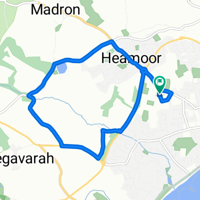
Vue d'ensemble
À propos du circuit
Si les conditions ne permettent pas le détour par St Loy et Penberth, tournez à droite à Boskenna Cross vers St Buryan puis à gauche sur Land’s End Road.
- -:--
- Durée
- 30,4 km
- Distance
- 575 m
- Montée
- 515 m
- Descente
- ---
- Vit. moyenne
- 110 m
- Altitude max.

Points forts de l’itinéraire
Points d’intérêt le long de l’itinéraire
Point d'intérêt après 9,5 km
Tater-du Lighthouse
Point d'intérêt après 11,6 km
The Merry Maidens Stone Circle
Point d'intérêt après 11,9 km
Tregiffian Burial Chamber Remains of a Neolithic or early–Bronze Age entrance tomb lined with large rock slabs.
Point d'intérêt après 12,5 km
Boskenna Cross
Point d'intérêt après 13,6 km
Boscawen Cliff
Point d'intérêt après 16,9 km
Penberth Cove
Point d'intérêt après 17,8 km
Treryn Dinas Impressive location of a scheduled monument Iron Age Fort - Treryn Dinas. Just off the South West Coast path, the remains of the fort stand alongside the Logan Rock balancing stone.
Point d'intérêt après 17,8 km
Logan Rock
Point d'intérêt après 18,4 km
Pedn Vounder Beach
Point d'intérêt après 21 km
Boscawen-un Stone Circle
Point d'intérêt après 21,2 km
Creeg Tol
Point d'intérêt après 27,9 km
Mayon Cliff Old Coastguard Lookout
Point d'intérêt après 29,2 km
Maen Castle
Point d'intérêt après 29,9 km
Nanjizal Beach
Point d'intérêt après 29,9 km
Carn Boel
Point d'intérêt après 29,9 km
Carn Les Boel
Point d'intérêt après 30,2 km
Pordenack Point
Point d'intérêt après 30,4 km
Enys Dodnan Arch
Point d'intérêt après 30,4 km
Land's End
Point d'intérêt après 30,4 km
First & Last House
Hébergement après 30,4 km
Land's End Hotel
Continuer avec Bikemap
Utilise, modifie ou télécharge cet itinéraire vélo
Tu veux parcourir LEJO'G 00 Penzance to Land's End ou l’adapter à ton propre voyage ? Voici ce que tu peux faire avec cet itinéraire Bikemap :
Fonctionnalités gratuites
- Enregistre cet itinéraire comme favori ou dans une collection
- Copie et planifie ta propre version de cet itinéraire
- Synchronise ton itinéraire avec Garmin ou Wahoo
Fonctionnalités Premium
Essai gratuit de 3 jours, ou paiement unique. En savoir plus sur Bikemap Premium.
- Navigue sur cet itinéraire sur iOS et Android
- Exporter un fichier GPX / KML de cet itinéraire
- Crée ton impression personnalisée (essaie-la gratuitement)
- Télécharge cet itinéraire pour la navigation hors ligne
Découvre plus de fonctionnalités Premium.
Obtiens Bikemap PremiumDe notre communauté
Penzance : Autres itinéraires populaires qui commencent ici
 17 Jun HSF Day 1
- Distance
- 38,5 km
- Montée
- 368 m
- Descente
- 371 m
- Emplacement
- Penzance, Angleterre, Royaume-Uni
 St Ives - Newquay
- Distance
- 49,3 km
- Montée
- 780 m
- Descente
- 643 m
- Emplacement
- Penzance, Angleterre, Royaume-Uni
 PZ Tri run route
- Distance
- 6,4 km
- Montée
- 71 m
- Descente
- 70 m
- Emplacement
- Penzance, Angleterre, Royaume-Uni
 E2E Northern Cornwall
- Distance
- 616,9 km
- Montée
- 1 462 m
- Descente
- 1 452 m
- Emplacement
- Penzance, Angleterre, Royaume-Uni
 Mousehole round trip
- Distance
- 58,5 km
- Montée
- 507 m
- Descente
- 507 m
- Emplacement
- Penzance, Angleterre, Royaume-Uni
 Penzance - Lands End - St Ives
- Distance
- 49,3 km
- Montée
- 515 m
- Descente
- 382 m
- Emplacement
- Penzance, Angleterre, Royaume-Uni
 PZ Tri bike route
- Distance
- 27,1 km
- Montée
- 292 m
- Descente
- 292 m
- Emplacement
- Penzance, Angleterre, Royaume-Uni
 Balanced Penzance, United Kingdom to Hayle, Hayle
- Distance
- 13,6 km
- Montée
- 65 m
- Descente
- 57 m
- Emplacement
- Penzance, Angleterre, Royaume-Uni
Ouvre-la dans l’app