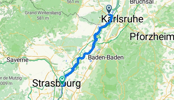
CYCLING THE RHINE: Route 17A
Un itinéraire vélo au départ de Wörth am Rhein, Rhénanie-Palatinat, Allemagne.
Vue d'ensemble
À propos du circuit
Gare de Wörth am Rhein (Mitte) à Gare de Kehl, suivant le fleuve Rhin.\n\nREMARQUE : L'aménagement routier entre Wörth am Rhein, à travers Maximiliansau jusqu'au Rhin, a considérablement changé et l'itinéraire décrit (dans le livre papier) ne s'applique plus. Cette carte montre l'itinéraire mis à jour dans cette zone.\n\nQuelques ajustements profitent des nouvelles pistes cyclables plus proches du Rhin.
- -:--
- Durée
- 82 km
- Distance
- 75 m
- Montée
- 41 m
- Descente
- ---
- Vit. moyenne
- ---
- Altitude max.
Qualité de l’itinéraire
Types de voies et surfaces le long de l’itinéraire
Types de routes
Route forestière
56,6 km
(69 %)
Route d'accès
5,7 km
(7 %)
surfaces
Pavé
33,6 km
(41 %)
Non pavé
42,6 km
(52 %)
Asphalte
32 km
(39 %)
Gravier
23 km
(28 %)
Points forts de l’itinéraire
Points d’intérêt le long de l’itinéraire
Hébergement après 5,2 km
Friends of Nature site. Rheinfrieden
Point d'intérêt après 13,1 km
Border between France and Germany.
Hébergement après 29,4 km
Guest House Anker. I have stayed here and found the service and facilities to be excellent.
Point d'intérêt après 65,6 km
Deviation from the described route (in the hard copy book) at this point, to take advantage of the riverside route.
Point d'intérêt après 80,6 km
Deviation from described route (in the hard copy book) at this point, to simplify the route. Rejoin described route at corner of Konigsberger and Elbinger Strassen.
Hébergement après 82 km
YOUTH HOSTEL: DJH Kehl. Altrhrheinweg 11, Kehl I have stayed at this hostel a number of times. I can recommend the facilities and cuisine.
Hébergement après 82 km
YOUTH HOSTEL: FUAJ Strasbourg, Parc du Rhin. I have stayed at this hostel. I would not stay here again.
Continuer avec Bikemap
Utilise, modifie ou télécharge cet itinéraire vélo
Tu veux parcourir CYCLING THE RHINE: Route 17A ou l’adapter à ton propre voyage ? Voici ce que tu peux faire avec cet itinéraire Bikemap :
Fonctionnalités gratuites
- Enregistre cet itinéraire comme favori ou dans une collection
- Copie et planifie ta propre version de cet itinéraire
- Divise-le en étapes pour créer un tour sur plusieurs jours
- Synchronise ton itinéraire avec Garmin ou Wahoo
Fonctionnalités Premium
Essai gratuit de 3 jours, ou paiement unique. En savoir plus sur Bikemap Premium.
- Navigue sur cet itinéraire sur iOS et Android
- Exporter un fichier GPX / KML de cet itinéraire
- Crée ton impression personnalisée (essaie-la gratuitement)
- Télécharge cet itinéraire pour la navigation hors ligne
Découvre plus de fonctionnalités Premium.
Obtiens Bikemap PremiumDe notre communauté
Wörth am Rhein : Autres itinéraires populaires qui commencent ici
 44_Wörth – Lauterbourg (F) – Wörth
- Distance
- 37,6 km
- Montée
- 71 m
- Descente
- 71 m
- Emplacement
- Wörth am Rhein, Rhénanie-Palatinat, Allemagne
 Elsassrunde
- Distance
- 60,2 km
- Montée
- 176 m
- Descente
- 187 m
- Emplacement
- Wörth am Rhein, Rhénanie-Palatinat, Allemagne
 Rhein Radweg 30Km Eben
- Distance
- 30,7 km
- Montée
- 81 m
- Descente
- 83 m
- Emplacement
- Wörth am Rhein, Rhénanie-Palatinat, Allemagne
 zum Schloßgarten und zum Brauhaus
- Distance
- 25,3 km
- Montée
- 79 m
- Descente
- 80 m
- Emplacement
- Wörth am Rhein, Rhénanie-Palatinat, Allemagne
 CYCLING THE RHINE: Route 17A
- Distance
- 82 km
- Montée
- 75 m
- Descente
- 41 m
- Emplacement
- Wörth am Rhein, Rhénanie-Palatinat, Allemagne
 Tag_1
Tag_1- Distance
- 60,4 km
- Montée
- 394 m
- Descente
- 322 m
- Emplacement
- Wörth am Rhein, Rhénanie-Palatinat, Allemagne
 Knielingen-Rhein-Mühlburg-Knielingen
- Distance
- 15,2 km
- Montée
- 34 m
- Descente
- 29 m
- Emplacement
- Wörth am Rhein, Rhénanie-Palatinat, Allemagne
 Deutsch-Französische Maifahrt 2010 - RTF des RSC Wörth 1980 e.V. - 133 km Strecke
- Distance
- 123,8 km
- Montée
- 601 m
- Descente
- 601 m
- Emplacement
- Wörth am Rhein, Rhénanie-Palatinat, Allemagne
Ouvre-la dans l’app

