
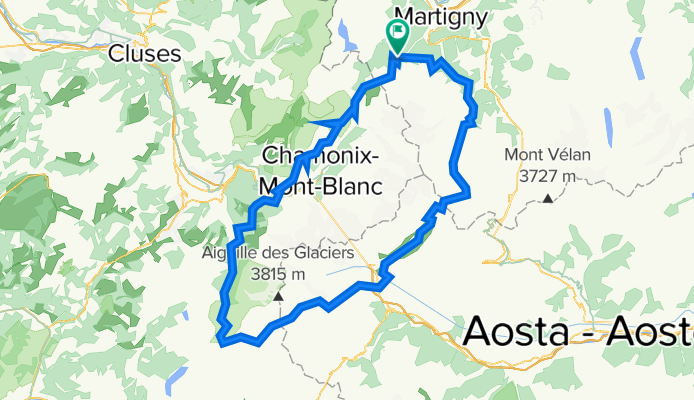
Hiking 120 Miles Alone on the Tour Du Mont Blanc Loop
Un itinéraire vélo au départ de Martigny-Combe, Canton du Valais, Suisse.
Vue d'ensemble
À propos du circuit
Le Tour du Mont Blanc est une boucle de 120 miles qui fait le tour du massif du Mont Blanc et traverse les Alpes suisses, françaises et italiennes. Chaque section de chaque pays a sa propre personnalité. Le sentier est bien entretenu et parsemé de balises colorées 'TMB'. Vous trouverez beaucoup d'autres personnes sur ce sentier, toutes en randonnée pour des raisons différentes. Il est généralement impossible de savoir depuis combien de temps quelqu'un randonne car le sentier est une boucle sans point de départ ou d'arrivée technique. Vous croiserez des randonneurs longue distance avec de gros sacs effectuant la boucle entière, des randonneurs d'un jour, des touristes en gondole, des coureurs de trail, des vététistes, des familles avec des chiens et des locaux prenant leur promenade matinale. Vous passerez par de petits villages cachés dans les montagnes et de grandes villes animées remplies de touristes. Le sentier est ponctué de refuges et de campings où vous pouvez manger, boire et dormir. Le sentier est sûr, rempli de personnes prêtes à vous aider si besoin, et très développé, de sorte que toute personne en bonne santé, avançant à son propre rythme, peut compléter la boucle complète. Je recommande le Tour du Mont Blanc à tous ceux qui tentent leur première randonnée de plus de 100 miles en raison de sa beauté, de sa difficulté modérée et de son faible risque. Bien que ce soit un sentier très populaire et très fréquenté en Europe, vous pouvez encore trouver des moments tranquilles d'isolement entre les villages et sur les cols de montagne loin de toute route ou gondole.
- -:--
- Durée
- 165,3 km
- Distance
- 12 832 m
- Montée
- 12 837 m
- Descente
- ---
- Vit. moyenne
- 2 663 m
- Altitude max.

Continuer avec Bikemap
Utilise, modifie ou télécharge cet itinéraire vélo
Tu veux parcourir Hiking 120 Miles Alone on the Tour Du Mont Blanc Loop ou l’adapter à ton propre voyage ? Voici ce que tu peux faire avec cet itinéraire Bikemap :
Fonctionnalités gratuites
- Enregistre cet itinéraire comme favori ou dans une collection
- Copie et planifie ta propre version de cet itinéraire
- Divise-le en étapes pour créer un tour sur plusieurs jours
- Synchronise ton itinéraire avec Garmin ou Wahoo
Fonctionnalités Premium
Essai gratuit de 3 jours, ou paiement unique. En savoir plus sur Bikemap Premium.
- Navigue sur cet itinéraire sur iOS et Android
- Exporter un fichier GPX / KML de cet itinéraire
- Crée ton impression personnalisée (essaie-la gratuitement)
- Télécharge cet itinéraire pour la navigation hors ligne
Découvre plus de fonctionnalités Premium.
Obtiens Bikemap PremiumDe notre communauté
Martigny-Combe : Autres itinéraires populaires qui commencent ici
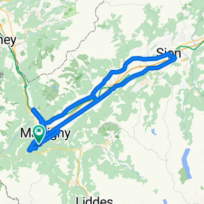
 Champex and Val Ferret
- Distance
- 62,9 km
- Montée
- 1 722 m
- Descente
- 1 722 m
- Emplacement
- Martigny-Combe, Canton du Valais, Suisse
 MontBlancTour5Tag
- Distance
- 14 km
- Montée
- 1 107 m
- Descente
- 935 m
- Emplacement
- Martigny-Combe, Canton du Valais, Suisse
 Trevor - Champex and Planche
- Distance
- 51,3 km
- Montée
- 1 740 m
- Descente
- 1 740 m
- Emplacement
- Martigny-Combe, Canton du Valais, Suisse
 Trevor Base Route
- Distance
- 93,3 km
- Montée
- 715 m
- Descente
- 715 m
- Emplacement
- Martigny-Combe, Canton du Valais, Suisse
 Startup Route des Grandes Alpes
- Distance
- 40 km
- Montée
- 1 360 m
- Descente
- 834 m
- Emplacement
- Martigny-Combe, Canton du Valais, Suisse
 Trevor - Champex lac loop
- Distance
- 42,5 km
- Montée
- 1 099 m
- Descente
- 1 099 m
- Emplacement
- Martigny-Combe, Canton du Valais, Suisse
 VTT MONT BLANC Vllorcine Albertville
- Distance
- 432,8 km
- Montée
- 8 172 m
- Descente
- 8 462 m
- Emplacement
- Martigny-Combe, Canton du Valais, Suisse
 Trevor Flat big loop
- Distance
- 73,5 km
- Montée
- 303 m
- Descente
- 303 m
- Emplacement
- Martigny-Combe, Canton du Valais, Suisse
Ouvre-la dans l’app