

Eastern promises cycling tour, version 1
Un itinéraire vélo au départ de Tallinn, Harju, Estonie.
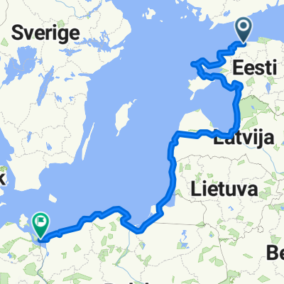
Vue d'ensemble
À propos du circuit
Through Estonia mines (could include Jõhvi)
- -:--
- Durée
- 557,5 km
- Distance
- 1 703 m
- Montée
- 1 619 m
- Descente
- ---
- Vit. moyenne
- 104 m
- Altitude max.
Qualité de l’itinéraire
Types de voies et surfaces le long de l’itinéraire
Types de routes
Route
245,3 km
(44 %)
Piste cyclable
83,6 km
(15 %)
surfaces
Pavé
473,9 km
(85 %)
Non pavé
16,7 km
(3 %)
Asphalte
468,3 km
(84 %)
Gravier
11,2 km
(2 %)
Points forts de l’itinéraire
Points d’intérêt le long de l’itinéraire
Point d'intérêt après 5,7 km
Velodrome (open-air, not in use anymore)

Point d'intérêt après 31 km
Cross the river over a pedestrian suspension bridge!
Point d'intérêt après 31,8 km
Linnamäe hydroelectric power plant (built 1922)
Point d'intérêt après 33,7 km
Jägala waterfall
Point d'intérêt après 72,2 km
Hara submarine demagnetisation station (Soviet era, now in private hands, can be visited for a small fee)
Point d'intérêt après 98,6 km
To save some km's, you could do a shortcut here
Point d'intérêt après 146,8 km
Vihula Manor, awesome place for spending the night
Point d'intérêt après 170,3 km
Toolse puhkeküla (camping huts)
Point d'intérêt après 177 km
Kunda is an old cement factory town (they still produce)
Point d'intérêt après 177,6 km
Kunda beach!
Point d'intérêt après 191,8 km
A little section of the busy 1+1 Tallinn-Narva road
Point d'intérêt après 211,9 km
Kiviõli new ash hill
Point d'intérêt après 213,7 km
Possible way up
Point d'intérêt après 213,7 km
Kiviõli old ash hill (you should be able to climb it)
Point d'intérêt après 213,8 km
Kiviõli adventure centre. Possibly you can climb up the hill from here!

Point d'intérêt après 230,5 km
Old quarries. You can take detours and explore.
Point d'intérêt après 233,9 km
Mining museum! Take the tour underground!
Point d'intérêt après 249,3 km
Magnificent clint for tenting. Can be decended to reach the sea, if you can find the secret ladders and/or have a rope.
Point d'intérêt après 252,8 km
Possibility to visit Jõhvi
Point d'intérêt après 270,3 km
Estonia kaevandus (mines). You could try and ask for an excursion. Or sneak up to the stone piles (they're high)
Point d'intérêt après 281,9 km
Kuremäe monastery
Point d'intérêt après 308,4 km
Vasknarva

Point d'intérêt après 315,5 km
Beach camping opportunities along the coast - set up your tent at the tree line
Point d'intérêt après 326,3 km
Remniku holiday centre
Point d'intérêt après 347,9 km
Popular beaches and camping sites
Point d'intérêt après 352,8 km
Juhandra Glamping: tenting with amenities.
Point d'intérêt après 401,1 km
Rentable cottages at Nina küla (Nina majad, strawbale houses), right on the coast
Point d'intérêt après 423,1 km
Barge crossing (Kavastu parv)
Point d'intérêt après 494,9 km
Buy some sweet treats from Rõngu Pagar (bakery)
Point d'intérêt après 510,2 km
Pikasilla is where Väike Emajõgi ("Small Mother River") flows into Võrtsjärv
Continuer avec Bikemap
Utilise, modifie ou télécharge cet itinéraire vélo
Tu veux parcourir Eastern promises cycling tour, version 1 ou l’adapter à ton propre voyage ? Voici ce que tu peux faire avec cet itinéraire Bikemap :
Fonctionnalités gratuites
- Enregistre cet itinéraire comme favori ou dans une collection
- Copie et planifie ta propre version de cet itinéraire
- Divise-le en étapes pour créer un tour sur plusieurs jours
- Synchronise ton itinéraire avec Garmin ou Wahoo
Fonctionnalités Premium
Essai gratuit de 3 jours, ou paiement unique. En savoir plus sur Bikemap Premium.
- Navigue sur cet itinéraire sur iOS et Android
- Exporter un fichier GPX / KML de cet itinéraire
- Crée ton impression personnalisée (essaie-la gratuitement)
- Télécharge cet itinéraire pour la navigation hors ligne
Découvre plus de fonctionnalités Premium.
Obtiens Bikemap PremiumDe notre communauté
Tallinn : Autres itinéraires populaires qui commencent ici
 Vaida-Kohila-Saku (MNT)
- Distance
- 101,6 km
- Montée
- 289 m
- Descente
- 286 m
- Emplacement
- Tallinn, Harju, Estonie
 Tallin - Usedom
- Distance
- 1 967,9 km
- Montée
- 549 m
- Descente
- 548 m
- Emplacement
- Tallinn, Harju, Estonie
 Untitled route
- Distance
- 300,1 km
- Montée
- 1 196 m
- Descente
- 1 197 m
- Emplacement
- Tallinn, Harju, Estonie
 EV106 yhiss6it
- Distance
- 48,8 km
- Montée
- 163 m
- Descente
- 163 m
- Emplacement
- Tallinn, Harju, Estonie
 Radwanderung Tallinn - Riga - Palanga - Liepaja
- Distance
- 939,1 km
- Montée
- 210 m
- Descente
- 219 m
- Emplacement
- Tallinn, Harju, Estonie
 Ümber Tallinna
- Distance
- 105,4 km
- Montée
- 150 m
- Descente
- 150 m
- Emplacement
- Tallinn, Harju, Estonie
 Jāņi
Jāņi- Distance
- 469,5 km
- Montée
- 368 m
- Descente
- 397 m
- Emplacement
- Tallinn, Harju, Estonie
 Kiisa-Hagudi-Kohila (MNT)
- Distance
- 109,4 km
- Montée
- 357 m
- Descente
- 356 m
- Emplacement
- Tallinn, Harju, Estonie
Ouvre-la dans l’app