

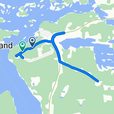
Campbell Street West 90, Little Current to Campbell Street West 90, Little Current
Un itinéraire vélo au départ de Little Current, Ontario, Canada.
Vue d'ensemble
À propos du circuit
- 3 h 43 min
- Durée
- 45,5 km
- Distance
- 293 m
- Montée
- 292 m
- Descente
- 12,2 km/h
- Vit. moyenne
- 324 m
- Altitude max.

Continuer avec Bikemap
Utilise, modifie ou télécharge cet itinéraire vélo
Tu veux parcourir Campbell Street West 90, Little Current to Campbell Street West 90, Little Current ou l’adapter à ton propre voyage ? Voici ce que tu peux faire avec cet itinéraire Bikemap :
Fonctionnalités gratuites
- Enregistre cet itinéraire comme favori ou dans une collection
- Copie et planifie ta propre version de cet itinéraire
- Synchronise ton itinéraire avec Garmin ou Wahoo
Fonctionnalités Premium
Essai gratuit de 3 jours, ou paiement unique. En savoir plus sur Bikemap Premium.
- Navigue sur cet itinéraire sur iOS et Android
- Exporter un fichier GPX / KML de cet itinéraire
- Crée ton impression personnalisée (essaie-la gratuitement)
- Télécharge cet itinéraire pour la navigation hors ligne
Découvre plus de fonctionnalités Premium.
Obtiens Bikemap PremiumDe notre communauté
Little Current : Autres itinéraires populaires qui commencent ici
 Rainbow Ridge Rd, Whitefish River (Part) 4 to Rainbow Ridge Rd, Whitefish River (Part) 4
- Distance
- 8,4 km
- Montée
- 54 m
- Descente
- 59 m
- Emplacement
- Little Current, Ontario, Canada
 Campbell Street West 90, Little Current to Campbell Street West 90, Little Current
- Distance
- 45,5 km
- Montée
- 293 m
- Descente
- 292 m
- Emplacement
- Little Current, Ontario, Canada
 48 km
48 km- Distance
- 61 km
- Montée
- 346 m
- Descente
- 332 m
- Emplacement
- Little Current, Ontario, Canada
 67–89 Limit St, Northeastern Manitoulin and the Islands to 67–89 Limit St, Northeastern Manitoulin and the Islands
- Distance
- 20,6 km
- Montée
- 300 m
- Descente
- 300 m
- Emplacement
- Little Current, Ontario, Canada
 67–89 Limit St, Northeastern Manitoulin and the Islands to 10944 Highway 6, Northeastern Manitoulin and the Islands
- Distance
- 20,5 km
- Montée
- 284 m
- Descente
- 284 m
- Emplacement
- Little Current, Ontario, Canada
 13 Blake St W, Northeastern Manitoulin and the Islands to 6 Blake St W, Northeastern Manitoulin and the Islands
- Distance
- 15,5 km
- Montée
- 77 m
- Descente
- 77 m
- Emplacement
- Little Current, Ontario, Canada
 Rainbow Ridge Rd, Whitefish River (Part) 4 to Rainbow Ridge Rd, Whitefish River (Part) 4
- Distance
- 6,4 km
- Montée
- 93 m
- Descente
- 99 m
- Emplacement
- Little Current, Ontario, Canada
 13 Blake St W, Northeastern Manitoulin and the Islands to 24 Blake St E, Northeastern Manitoulin and the Islands
- Distance
- 17,5 km
- Montée
- 85 m
- Descente
- 80 m
- Emplacement
- Little Current, Ontario, Canada
Ouvre-la dans l’app