![1: Taichung, Beitun to Dongshr [all flat, no cars, good for beginners]](/_next/static/media/contour-lines-light-small.cafd5e5d.avif)
![1: Taichung, Beitun to Dongshr [all flat, no cars, good for beginners]](https://media.bikemap.net/routes/1165846/staticmaps/in_30170be6-5275-4e24-b820-4f9524fb857e_694x400_bikemap-2021-3D-static.png)
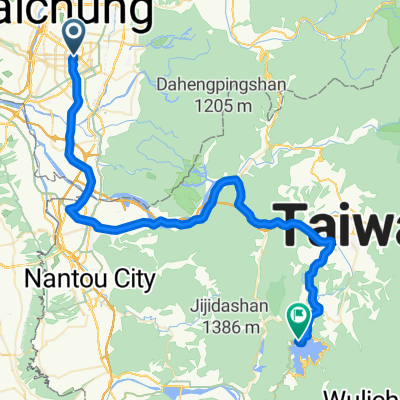
1: Taichung, Beitun to Dongshr [all flat, no cars, good for beginners]
Un itinéraire vélo au départ de Taichung, Taiwan, Taïwan.
Vue d'ensemble
À propos du circuit
Start at the 7-Eleven on the corner of Dongshan Rd* [<span id="result_box" class="short_text" lang="zh-TW"><span>東</span></span>山<span id="result_box" class="short_text" lang="zh-TW"><span>路</span></span>] and Hanshi W Rd, Sec 3 [旱溪<span id="result_box" class="short_text" lang="zh-TW"><span>西</span></span><span id="result_box" class="short_text" lang="zh-TW"><span>路</span></span>三段].
A nice easy ride without cars along tree-lined paths.
It's a gentle incline all the way to Dongshr, but that also means a nice, long downhill all the way home.
52km return journey.
*Dongshan Rd is an extension of Wenxing Rd [文心<span id="result_box" class="short_text" lang="zh-TW"><span>路</span></span>] to the West.
- -:--
- Durée
- 26,1 km
- Distance
- 272 m
- Montée
- 39 m
- Descente
- ---
- Vit. moyenne
- ---
- Altitude max.
Points forts de l’itinéraire
Points d’intérêt le long de l’itinéraire
Point d'intérêt après 1,8 km
There are paths on both banks of the river. However, the construction of the new expressway requires us to travel on the East bank. <br /><br />Only the occasional scooter from here to the 7-Eleven in Fongyuan [8km].
Point d'intérêt après 4,5 km
Cross the bridge here
Point d'intérêt après 9,6 km
If we're meeting in Fongyuan, we'll meet at this 7-Eleven.
Point d'intérêt après 15 km
No cars for the next 10km!
Continuer avec Bikemap
Utilise, modifie ou télécharge cet itinéraire vélo
Tu veux parcourir 1: Taichung, Beitun to Dongshr [all flat, no cars, good for beginners] ou l’adapter à ton propre voyage ? Voici ce que tu peux faire avec cet itinéraire Bikemap :
Fonctionnalités gratuites
- Enregistre cet itinéraire comme favori ou dans une collection
- Copie et planifie ta propre version de cet itinéraire
- Synchronise ton itinéraire avec Garmin ou Wahoo
Fonctionnalités Premium
Essai gratuit de 3 jours, ou paiement unique. En savoir plus sur Bikemap Premium.
- Navigue sur cet itinéraire sur iOS et Android
- Exporter un fichier GPX / KML de cet itinéraire
- Crée ton impression personnalisée (essaie-la gratuitement)
- Télécharge cet itinéraire pour la navigation hors ligne
Découvre plus de fonctionnalités Premium.
Obtiens Bikemap PremiumDe notre communauté
Taichung : Autres itinéraires populaires qui commencent ici
 太平_老鼠崎
- Distance
- 8,4 km
- Montée
- 473 m
- Descente
- 457 m
- Emplacement
- Taichung, Taiwan, Taïwan
 台中-日月潭
- Distance
- 72,4 km
- Montée
- 1 089 m
- Descente
- 559 m
- Emplacement
- Taichung, Taiwan, Taïwan
 136
136- Distance
- 19,3 km
- Montée
- 754 m
- Descente
- 297 m
- Emplacement
- Taichung, Taiwan, Taïwan
 一日一望高 可以遠離醫生
- Distance
- 36 km
- Montée
- 334 m
- Descente
- 311 m
- Emplacement
- Taichung, Taiwan, Taïwan
 華盛頓中學_四方太子宮
- Distance
- 5,7 km
- Montée
- 345 m
- Descente
- 151 m
- Emplacement
- Taichung, Taiwan, Taïwan
 傳說中的136
- Distance
- 19,2 km
- Montée
- 997 m
- Descente
- 961 m
- Emplacement
- Taichung, Taiwan, Taïwan
 竹仔坑虹橋_牛角坑自行車道_後壁農路_光興路
- Distance
- 13,2 km
- Montée
- 615 m
- Descente
- 622 m
- Emplacement
- Taichung, Taiwan, Taïwan
 環島路線-海線
- Distance
- 1 073 km
- Montée
- 1 095 m
- Descente
- 1 095 m
- Emplacement
- Taichung, Taiwan, Taïwan
Ouvre-la dans l’app