

Tarmac alternative (NCN68) missing off road/ crossing fields at Clennell.
Un itinéraire vélo au départ de Rochester, England, United Kingdom.
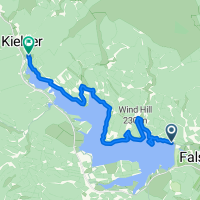
Vue d'ensemble
À propos du circuit
<!-- /* Style Definitions */ p.MsoNormal, li.MsoNormal, div.MsoNormal {mso-style-parent:""; margin:0cm; margin-bottom:.0001pt; mso-pagination:widow-orphan; font-size:12.0pt; font-family:"Times New Roman"; mso-fareast-font-family:"Times New Roman";} @page Section1 {size:612.0pt 792.0pt; margin:72.0pt 90.0pt 72.0pt 90.0pt; mso-header-margin:36.0pt; mso-footer-margin:36.0pt; mso-paper-source:0;} div.Section1 {page:Section1;} --> <span style="font-size: 12pt; font-family: "Times New Roman";">This is a tarmac alternative to the off road section of the Sustrans 'Pennine cycleway' NCN route 68 from Alwinton through Clennell. It's the same sort of distance.</span>
- -:--
- Durée
- 3,9 km
- Distance
- 106 m
- Montée
- 10 m
- Descente
- ---
- Vit. moyenne
- 256 m
- Altitude max.

Qualité de l’itinéraire
Types de voies et surfaces le long de l’itinéraire
Types de routes
Route
3,3 km
(83 %)
Route tranquille
0,6 km
(17 %)
Continuer avec Bikemap
Utilise, modifie ou télécharge cet itinéraire vélo
Tu veux parcourir Tarmac alternative (NCN68) missing off road/ crossing fields at Clennell. ou l’adapter à ton propre voyage ? Voici ce que tu peux faire avec cet itinéraire Bikemap :
Fonctionnalités gratuites
- Enregistre cet itinéraire comme favori ou dans une collection
- Copie et planifie ta propre version de cet itinéraire
- Synchronise ton itinéraire avec Garmin ou Wahoo
Fonctionnalités Premium
Essai gratuit de 3 jours, ou paiement unique. En savoir plus sur Bikemap Premium.
- Navigue sur cet itinéraire sur iOS et Android
- Exporter un fichier GPX / KML de cet itinéraire
- Crée ton impression personnalisée (essaie-la gratuitement)
- Télécharge cet itinéraire pour la navigation hors ligne
Découvre plus de fonctionnalités Premium.
Obtiens Bikemap PremiumDe notre communauté
Rochester : Autres itinéraires populaires qui commencent ici
 Tour de Wielka Brytania & Irlandia 2019 dzień 17
- Distance
- 143,7 km
- Montée
- 1 118 m
- Descente
- 1 248 m
- Emplacement
- Rochester, England, United Kingdom
 Kielder észak
- Distance
- 17,1 km
- Montée
- 178 m
- Descente
- 185 m
- Emplacement
- Rochester, England, United Kingdom
 LEJOG - Day 10
- Distance
- 112,6 km
- Montée
- 921 m
- Descente
- 1 112 m
- Emplacement
- Rochester, England, United Kingdom
 Lew and Cal round Kielder
- Distance
- 41,6 km
- Montée
- 253 m
- Descente
- 253 m
- Emplacement
- Rochester, England, United Kingdom
 Rochester Cycling
- Distance
- 40,1 km
- Montée
- 519 m
- Descente
- 522 m
- Emplacement
- Rochester, England, United Kingdom
 Kielder Water
- Distance
- 48,4 km
- Montée
- 444 m
- Descente
- 444 m
- Emplacement
- Rochester, England, United Kingdom
 Periple 11 / 28
- Distance
- 167,7 km
- Montée
- 1 250 m
- Descente
- 1 182 m
- Emplacement
- Rochester, England, United Kingdom
 Tarmac alternative (NCN68) missing off road/ crossing fields at Clennell.
- Distance
- 3,9 km
- Montée
- 106 m
- Descente
- 10 m
- Emplacement
- Rochester, England, United Kingdom
Ouvre-la dans l’app