

Mississauga (Celebration Square) Through Toronto Waterfront and and Back
Un itinéraire vélo au départ de Mississauga, Ontario, Canada.
Vue d'ensemble
À propos du circuit
OVERVIEW: A round-trip that is mostly on trails and bike lanes. Very few of the route is on actual road - that is, the Downtown Toronto part. Feels like a nice adventure. Although the Queensway part may be quite boring, it adds some variety! However, there will be a lot of riders like you on the Waterfront Trail, so don't fret.
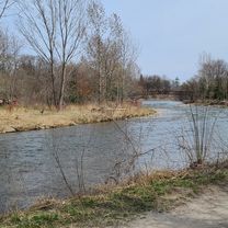
ROUTE DESCRIPTION: The route starts by skipping Port Credit and goes the edge of Mississauga next to the Etobicoke Creek. This is because that part is mostly in residential neighborhoods. Dixie's trails takes us to Marie Curtis Park (which is when we enter Etobicoke) then we connect to the Waterfront Trail. We'll take the Waterfront trail down to Downtown TO, going through places like St Lawrence Market, Eaton Centre, Nathan Philips and Yonge/Dundas Square, as well as around the entertainment district. Heading back, we will visit High Park and complete a loop around that park. Upon arriving to Mississauga, we'll finally take a glance at Port Credit's several parks, then after we'll take some trails and different roads back north to Celebration Square.
LENGTH: This route takes around 2 1/2 to 3 hours for more experienced cyclists, whereas 4 hours is more realistic.
I hope you enjoy this route! Feel free to visit anywhere you wish in Toronto. Feedback is appreciated!
- -:--
- Durée
- 83,7 km
- Distance
- 585 m
- Montée
- 585 m
- Descente
- ---
- Vit. moyenne
- 165 m
- Altitude max.

Qualité de l’itinéraire
Types de voies et surfaces le long de l’itinéraire
Types de routes
Piste cyclable
33,3 km
(40 %)
Route tranquille
18,2 km
(22 %)
surfaces
Pavé
72,8 km
(87 %)
Non pavé
0,1 km
(<1 %)
Asphalte
69,1 km
(83 %)
Béton
3,2 km
(4 %)
Continuer avec Bikemap
Utilise, modifie ou télécharge cet itinéraire vélo
Tu veux parcourir Mississauga (Celebration Square) Through Toronto Waterfront and and Back ou l’adapter à ton propre voyage ? Voici ce que tu peux faire avec cet itinéraire Bikemap :
Fonctionnalités gratuites
- Enregistre cet itinéraire comme favori ou dans une collection
- Copie et planifie ta propre version de cet itinéraire
- Divise-le en étapes pour créer un tour sur plusieurs jours
- Synchronise ton itinéraire avec Garmin ou Wahoo
Fonctionnalités Premium
Essai gratuit de 3 jours, ou paiement unique. En savoir plus sur Bikemap Premium.
- Navigue sur cet itinéraire sur iOS et Android
- Exporter un fichier GPX / KML de cet itinéraire
- Crée ton impression personnalisée (essaie-la gratuitement)
- Télécharge cet itinéraire pour la navigation hors ligne
Découvre plus de fonctionnalités Premium.
Obtiens Bikemap PremiumDe notre communauté
Mississauga : Autres itinéraires populaires qui commencent ici
 Erindale route...long
- Distance
- 29,6 km
- Montée
- 296 m
- Descente
- 289 m
- Emplacement
- Mississauga, Ontario, Canada
 Etobicoke-Lakeshore-Miss Road
- Distance
- 40,5 km
- Montée
- 133 m
- Descente
- 131 m
- Emplacement
- Mississauga, Ontario, Canada
 belfountain ride
- Distance
- 74 km
- Montée
- 405 m
- Descente
- 405 m
- Emplacement
- Mississauga, Ontario, Canada
 30k around the block
- Distance
- 29,1 km
- Montée
- 124 m
- Descente
- 127 m
- Emplacement
- Mississauga, Ontario, Canada
 Riverwood-SawmillValley-Culham Loop
- Distance
- 10,1 km
- Montée
- 90 m
- Descente
- 93 m
- Emplacement
- Mississauga, Ontario, Canada
 Day2_Missiisauga to Niagara Falls
- Distance
- 119,8 km
- Montée
- 385 m
- Descente
- 354 m
- Emplacement
- Mississauga, Ontario, Canada
 2689 Hollington Cres, Mississauga to 2652 Hollington Cres, Mississauga
- Distance
- 16,2 km
- Montée
- 162 m
- Descente
- 161 m
- Emplacement
- Mississauga, Ontario, Canada
 Warmup Churchill to Brittania and back
- Distance
- 23,8 km
- Montée
- 67 m
- Descente
- 64 m
- Emplacement
- Mississauga, Ontario, Canada
Ouvre-la dans l’app