

Moab through Arches and Back
Un itinéraire vélo au départ de Moab, Utah, États Unis.
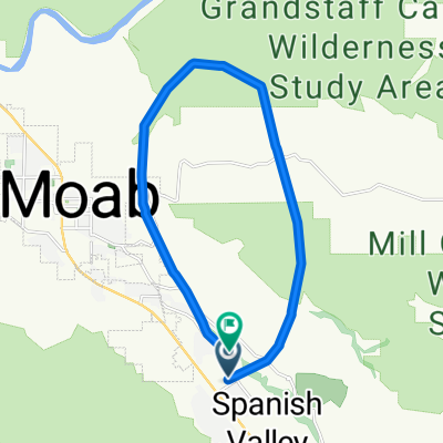
Vue d'ensemble
À propos du circuit
C'est tout simplement l'une des plus belles randonnées à vélo sur route au monde. À un peu moins de 44 miles, vous gagnez et perdez 3300 pieds (1000 mètres) à travers l'un des plus beaux parcs nationaux d'Amérique. Il n'y a pas de piste cyclable, alors roulez simplement sur le côté de la route et faites attention aux conducteurs. Apportez beaucoup d'eau et partez tôt pendant les mois d'été. Gagner autant d'altitude signifie que vous devez être prêt à un changement de température au printemps et en automne. L'hiver peut être assez froid, mais des journées sèches et vraiment chaudes sont possibles. Il y a de l'eau à Devils Garden, le point le plus élevé et à l'extrémité, et il y a de l'eau au siège du parc à environ 4 miles dans la randonnée. Prenez le chemin à vélo le long de l'autoroute lorsque vous partez et entrez dans le parc. Il y a des frais pour entrer dans le parc (je ne suis pas sûr de ce que c'est). Si vous êtes un visiteur et avez besoin d'un vélo, essayez Poison Spider au nord de Moab.
- -:--
- Durée
- 69,8 km
- Distance
- 1 017 m
- Montée
- 1 024 m
- Descente
- ---
- Vit. moyenne
- ---
- Altitude max.
Qualité de l’itinéraire
Types de voies et surfaces le long de l’itinéraire
Types de routes
Route
18,9 km
(27 %)
Piste cyclable
11,9 km
(17 %)
surfaces
Pavé
69,1 km
(99 %)
Asphalte
67 km
(96 %)
Pavé (non défini)
2,1 km
(3 %)
Indéfini
0,7 km
(1 %)
Continuer avec Bikemap
Utilise, modifie ou télécharge cet itinéraire vélo
Tu veux parcourir Moab through Arches and Back ou l’adapter à ton propre voyage ? Voici ce que tu peux faire avec cet itinéraire Bikemap :
Fonctionnalités gratuites
- Enregistre cet itinéraire comme favori ou dans une collection
- Copie et planifie ta propre version de cet itinéraire
- Synchronise ton itinéraire avec Garmin ou Wahoo
Fonctionnalités Premium
Essai gratuit de 3 jours, ou paiement unique. En savoir plus sur Bikemap Premium.
- Navigue sur cet itinéraire sur iOS et Android
- Exporter un fichier GPX / KML de cet itinéraire
- Crée ton impression personnalisée (essaie-la gratuitement)
- Télécharge cet itinéraire pour la navigation hors ligne
Découvre plus de fonctionnalités Premium.
Obtiens Bikemap PremiumDe notre communauté
Moab : Autres itinéraires populaires qui commencent ici
 Moab to Mineral Bottom Road
- Distance
- 75,4 km
- Montée
- 688 m
- Descente
- 690 m
- Emplacement
- Moab, Utah, États Unis
 Moab - A Pretty Flat Route to Potash
- Distance
- 66,2 km
- Montée
- 1 097 m
- Descente
- 1 092 m
- Emplacement
- Moab, Utah, États Unis
 Moab Gran Fondo Loop
- Distance
- 94,5 km
- Montée
- 1 824 m
- Descente
- 1 675 m
- Emplacement
- Moab, Utah, États Unis
 Moab
Moab- Distance
- 17,3 km
- Montée
- 691 m
- Descente
- 708 m
- Emplacement
- Moab, Utah, États Unis
 Moab 100
- Distance
- 159,6 km
- Montée
- 957 m
- Descente
- 957 m
- Emplacement
- Moab, Utah, États Unis
 Potash Road
- Distance
- 68,6 km
- Montée
- 685 m
- Descente
- 688 m
- Emplacement
- Moab, Utah, États Unis
 Salt Wash-DAV
- Distance
- 11,9 km
- Montée
- 469 m
- Descente
- 356 m
- Emplacement
- Moab, Utah, États Unis
 Porcupine Rim Trail
- Distance
- 22,9 km
- Montée
- 529 m
- Descente
- 1 054 m
- Emplacement
- Moab, Utah, États Unis
Ouvre-la dans l’app