

DAY ONE Châtellerault - Savigny-sous-Faye
Un itinéraire vélo au départ de Châtellerault, Nouvelle-Aquitaine, France.
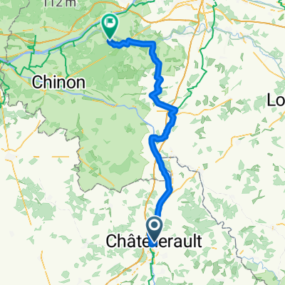
Vue d'ensemble
À propos du circuit
Day One
Gare Châtellerault - Camping Municipal Les Iris, Savigny-sous-Faye
The route starts in Châtellerault in the Vienne Department of Nouvelle-Aquitaine. After an early morning TER train, Châtellerault will provide time for breakfast and a brief look around the town before seeking out the start of La Ligne Verte. Châtellerault has links with Scotland, namely, that in return for services offered to the Crowns of Scotland and France, the title of Duc de Châtellerault(1548) was presented to James Hamilton, 2nd Earl of Arran, Chief of the Name, and regent of Scotland during the infancy of Mary, Queen of Scots, and of France. However, he turned against the Queen in 1559, and his French estates and title were confiscated. This period in Scots history can be recalled to this day in the name of the village of Chatelherault in North Lanarkshire, Scotland - close to where the Duke of Hamilton once had a very grand palace and close to where I live. The spelling, for reasons unknown, (perhaps in writing or in error) is not exactly that of the town in France. La Ligne Verte is an old railway line converted into a cycle path and walking trails that runs from Châtellerault to Loudun, through the Lencloître area. This cycle route is known locally as Voie Sylvain Chavane. Sylvain Chavane, born in Châtellerault, was a French professional road cycling racer between 2000 and 2018. The start of the ligne verte is reached from the east side of Pont Henri IV, then crossing the River Vienne and taking a short cycle through some city streets.
This first day stage of the route ends at a campsite in Savigny-sous-Faye.
Camping Municipal Les Iris
4 rue du Lavior,
86140 Savigny-sous-Faye
FRANCE
Tel: +33 5 49 90 70 59
Mobile: +33 7 71 87 04 09
- 1 h 26 min
- Durée
- 24,5 km
- Distance
- 138 m
- Montée
- 79 m
- Descente
- 17,1 km/h
- Vit. moyenne
- 114 m
- Altitude max.

Qualité de l’itinéraire
Types de voies et surfaces le long de l’itinéraire
Types de routes
Piste cyclable
15,4 km
(63 %)
Route tranquille
3,7 km
(15 %)
surfaces
Pavé
13,9 km
(57 %)
Asphalte
13,9 km
(57 %)
Indéfini
10,5 km
(43 %)
Continuer avec Bikemap
Utilise, modifie ou télécharge cet itinéraire vélo
Tu veux parcourir DAY ONE Châtellerault - Savigny-sous-Faye ou l’adapter à ton propre voyage ? Voici ce que tu peux faire avec cet itinéraire Bikemap :
Fonctionnalités gratuites
- Enregistre cet itinéraire comme favori ou dans une collection
- Copie et planifie ta propre version de cet itinéraire
- Synchronise ton itinéraire avec Garmin ou Wahoo
Fonctionnalités Premium
Essai gratuit de 3 jours, ou paiement unique. En savoir plus sur Bikemap Premium.
- Navigue sur cet itinéraire sur iOS et Android
- Exporter un fichier GPX / KML de cet itinéraire
- Crée ton impression personnalisée (essaie-la gratuitement)
- Télécharge cet itinéraire pour la navigation hors ligne
Découvre plus de fonctionnalités Premium.
Obtiens Bikemap PremiumDe notre communauté
Châtellerault : Autres itinéraires populaires qui commencent ici
 FR15 Chatelleraut - Cheillé
- Distance
- 78,3 km
- Montée
- 460 m
- Descente
- 461 m
- Emplacement
- Châtellerault, Nouvelle-Aquitaine, France
 tour du clain
- Distance
- 42 km
- Montée
- 231 m
- Descente
- 231 m
- Emplacement
- Châtellerault, Nouvelle-Aquitaine, France
 11 Tag Châtellerault - Niort
- Distance
- 112,6 km
- Montée
- 350 m
- Descente
- 379 m
- Emplacement
- Châtellerault, Nouvelle-Aquitaine, France
 France20.5 Chatellerault-Confolens
- Distance
- 109 km
- Montée
- 356 m
- Descente
- 281 m
- Emplacement
- Châtellerault, Nouvelle-Aquitaine, France
 (4) Final Chattelerault - Bordeaux, 282km, 990HM (camping)
- Distance
- 282,2 km
- Montée
- 574 m
- Descente
- 592 m
- Emplacement
- Châtellerault, Nouvelle-Aquitaine, France
 Châtellerault - Lussac-les-châteaux (58km) - Chabanais (130km) - Montbrond (174 km) - Angoulème (220 km)
- Distance
- 216,9 km
- Montée
- 1 908 m
- Descente
- 1 856 m
- Emplacement
- Châtellerault, Nouvelle-Aquitaine, France
 dag 5 chatelleraut naar nabij Savigne
- Distance
- 92,5 km
- Montée
- 601 m
- Descente
- 537 m
- Emplacement
- Châtellerault, Nouvelle-Aquitaine, France
 dangé velleches usseau
- Distance
- 39,7 km
- Montée
- 374 m
- Descente
- 374 m
- Emplacement
- Châtellerault, Nouvelle-Aquitaine, France
Ouvre-la dans l’app