
X stage 25..... lorient - Pornic 16 Sept 2012
Un itinéraire vélo au départ de Lorient, Région Bretagne, France.
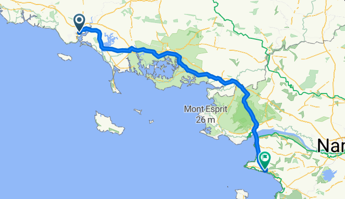
Vue d'ensemble
À propos du circuit
Mairie de Lorient2 boulevard general leclerc56101 lorient cedexàMairie de PornicPlace de l'hotel de villeBP 140944210 pornic
- -:--
- Durée
- 159,8 km
- Distance
- 260 m
- Montée
- 251 m
- Descente
- ---
- Vit. moyenne
- ---
- Altitude max.

Qualité de l’itinéraire
Types de voies et surfaces le long de l’itinéraire
Types de routes
Route tranquille
22,4 km
(14 %)
Piste cyclable
22,4 km
(14 %)
surfaces
Pavé
70,3 km
(44 %)
Non pavé
3,2 km
(2 %)
Asphalte
70,3 km
(44 %)
Gravier
1,6 km
(1 %)
Continuer avec Bikemap
Utilise, modifie ou télécharge cet itinéraire vélo
Tu veux parcourir X stage 25..... lorient - Pornic 16 Sept 2012 ou l’adapter à ton propre voyage ? Voici ce que tu peux faire avec cet itinéraire Bikemap :
Fonctionnalités gratuites
- Enregistre cet itinéraire comme favori ou dans une collection
- Copie et planifie ta propre version de cet itinéraire
- Divise-le en étapes pour créer un tour sur plusieurs jours
- Synchronise ton itinéraire avec Garmin ou Wahoo
Fonctionnalités Premium
Essai gratuit de 3 jours, ou paiement unique. En savoir plus sur Bikemap Premium.
- Navigue sur cet itinéraire sur iOS et Android
- Exporter un fichier GPX / KML de cet itinéraire
- Crée ton impression personnalisée (essaie-la gratuitement)
- Télécharge cet itinéraire pour la navigation hors ligne
Découvre plus de fonctionnalités Premium.
Obtiens Bikemap PremiumDe notre communauté
Lorient : Autres itinéraires populaires qui commencent ici
 X stage 25..... lorient - Pornic 16 Sept 2012
- Distance
- 159,8 km
- Montée
- 260 m
- Descente
- 251 m
- Emplacement
- Lorient, Région Bretagne, France
 16 Rue de Vauban, Lorient to Boulevard de l'Atlantique, Ploemeur
- Distance
- 13,7 km
- Montée
- 75 m
- Descente
- 83 m
- Emplacement
- Lorient, Région Bretagne, France
 Lorient Carnac
- Distance
- 37,1 km
- Montée
- 127 m
- Descente
- 108 m
- Emplacement
- Lorient, Région Bretagne, France
 15 Rue de l'Entente Cordiale, Lorient à 6 Impasse de la Cale, Lanester
- Distance
- 33,4 km
- Montée
- 120 m
- Descente
- 135 m
- Emplacement
- Lorient, Région Bretagne, France
 Cour Masse, Lorient nach 8 Impasse Jérôme Ruseff, Larmor-Plage
- Distance
- 3,7 km
- Montée
- 20 m
- Descente
- 27 m
- Emplacement
- Lorient, Région Bretagne, France
 22/08/2017
- Distance
- 85,9 km
- Montée
- 417 m
- Descente
- 418 m
- Emplacement
- Lorient, Région Bretagne, France
 Frankreich 2002 08
- Distance
- 167,7 km
- Montée
- 322 m
- Descente
- 320 m
- Emplacement
- Lorient, Région Bretagne, France
 10-M. Lorient - Nantes (170,5 Km)
- Distance
- 170,5 km
- Montée
- 1 048 m
- Descente
- 1 021 m
- Emplacement
- Lorient, Région Bretagne, France
Ouvre-la dans l’app