
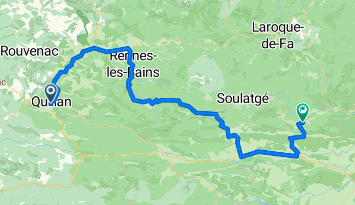
Ride Day 17—27 Sept 2005—11500 Quillan to 11350 Cucugnan
Un itinéraire vélo au départ de Quillan, Occitanie, France.
Vue d'ensemble
À propos du circuit
À l'exception de deux routes principales (D118 et D117), la randonnée d'aujourd'hui était vraiment exceptionnelle.
La D14 a grimpé à travers une belle région qui devient quelque peu aride près du Pic de Bugarach, une vue magnifique sous tous les angles. Le Pic de Bugarach s'élève à 1230 m et nous sommes passés près de lui au Col du Linas à 680 m. Cette année, nous allions d'ouest en est. Il y a quatre ans, nous avions parcouru cette route d'est en ouest.
La D10/D17 nous a conduit à travers une magnifique gorge avec une route étroite taillée dans les flancs. Route incroyable et paysages magnifiques. Pendant plusieurs heures sur cette route, nous avons traversé le département des Pyrénées-Orientales avant de revenir dans l'Aude par la D19/D123. Cette dernière route de Maury à Cucugnan était une belle montée au-dessus d'une vallée entourée de montagnes. Cette montée nous a menés au Grau de Maury à 432 m, où une route monte encore plus haut jusqu'au Château de Quéribus. Depuis le Grau de Maury, nous avons descendu directement à Cucugnan, situé sur une petite colline dans une autre grande vallée entourée de montagnes. Comme dans la vallée de Maury, il y a de nombreux vignobles.
Contexte :
Ma femme et moi faisons des tours auto-suffisants en Europe de l'Ouest (principalement en France) depuis 1993. Cette série de sorties couvre notre itinéraire de 2 mois en 2005 à travers certaines parties de la France. Notre point de départ et d'arrivée est près de Chaduri (au sud d'Angoulême) où nos amis ont une ferme avec des Gîtes et Chambres d'Hôtes.
Nous roulions sur nos vélos de tourisme Dawes achetés en 1993, lourdement chargés avec des pneus 700Cx32. Toutes nos sorties étaient sur des routes pavées, pour la plupart avec très peu de trafic.
Pour toute question, n'hésitez pas à m'envoyer un e-mail à jeffkadet@netdiving.com
Jeff
- -:--
- Durée
- 66,6 km
- Distance
- 778 m
- Montée
- 790 m
- Descente
- ---
- Vit. moyenne
- ---
- Altitude max.

Continuer avec Bikemap
Utilise, modifie ou télécharge cet itinéraire vélo
Tu veux parcourir Ride Day 17—27 Sept 2005—11500 Quillan to 11350 Cucugnan ou l’adapter à ton propre voyage ? Voici ce que tu peux faire avec cet itinéraire Bikemap :
Fonctionnalités gratuites
- Enregistre cet itinéraire comme favori ou dans une collection
- Copie et planifie ta propre version de cet itinéraire
- Synchronise ton itinéraire avec Garmin ou Wahoo
Fonctionnalités Premium
Essai gratuit de 3 jours, ou paiement unique. En savoir plus sur Bikemap Premium.
- Navigue sur cet itinéraire sur iOS et Android
- Exporter un fichier GPX / KML de cet itinéraire
- Crée ton impression personnalisée (essaie-la gratuitement)
- Télécharge cet itinéraire pour la navigation hors ligne
Découvre plus de fonctionnalités Premium.
Obtiens Bikemap PremiumDe notre communauté
Quillan : Autres itinéraires populaires qui commencent ici
 Quillan - Grandvalira Sector Carrillo
- Distance
- 191,1 km
- Montée
- 4 499 m
- Descente
- 2 756 m
- Emplacement
- Quillan, Occitanie, France
 etapa 2 - R
- Distance
- 142,7 km
- Montée
- 2 047 m
- Descente
- 1 940 m
- Emplacement
- Quillan, Occitanie, France
 2009 Entre-deux-mers - 2
- Distance
- 259,7 km
- Montée
- 79 m
- Descente
- 328 m
- Emplacement
- Quillan, Occitanie, France
 VTT Pyrénées - circuit n°22
- Distance
- 29,8 km
- Montée
- 584 m
- Descente
- 584 m
- Emplacement
- Quillan, Occitanie, France
 Couple of Cols Around Puivert
- Distance
- 41,1 km
- Montée
- 626 m
- Descente
- 628 m
- Emplacement
- Quillan, Occitanie, France
 Stage 4 - Cent Cols
- Distance
- 118,6 km
- Montée
- 2 625 m
- Descente
- 2 439 m
- Emplacement
- Quillan, Occitanie, France
 Ride Day 17—27 Sept 2005—11500 Quillan to 11350 Cucugnan
- Distance
- 66,6 km
- Montée
- 778 m
- Descente
- 790 m
- Emplacement
- Quillan, Occitanie, France
 MBLEspinetQuillan
- Distance
- 21,1 km
- Montée
- 558 m
- Descente
- 556 m
- Emplacement
- Quillan, Occitanie, France
Ouvre-la dans l’app