

Ride Day 22—3 Oct 2005—34220 St-Pons-de-Thomières to 81320 Murat-sur-Vèbre
Un itinéraire vélo au départ de Saint-Pons-de-Thomières, Occitanie, France.
Vue d'ensemble
À propos du circuit
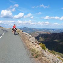
<span style="font-size: 12pt; font-family: Arial;">Today’s area and roads were outstanding.<span> </span>Only D907 had more traffic than we would have liked.<span> </span>Also, we passed from the Hérault Department into the Tarn Department.<span> </span>This also meant that we’d left the Languedoc-Roussillon Region and entered the Midi-Pyrénées Region.</span>
<span style="font-size: 12pt; font-family: Arial;">Starting from St Pons at 320 M, we immediately climbed to 941 M at the first col and from then until arriving in Murat, we descended and climbed within a 200 or so meter band until finishing at 840 M in Murat.</span>
<span style="font-size: 12pt; font-family: Arial;">Just before reaching the first col, we stopped and were just about frozen by the gale force cold wind.<span> </span>After putting on our rain pants, jerseys and gloves, we felt much better.<span> </span>Happily, we had no rain until the last four miles or so along D162Cand D162 into Murat.</span>
Background:<br /><br /><br />My wife and I have been doing self-supported tours in Western Europe (a majority in France) since 1993. This series of rides covers our 2005 2 month route through parts of France. Our beginning and ending point is near Chaduri (south of Angoulême) where our friends have a farm with Gites and Chambres d'Hotes.<br /><br /><br />We rode our Dawes touring bicycles purchased in 1993 heavily loaded with 700Cx32 tires. All of our riding was on paved roads, mostly with very little traffic.<br /><br /><br />If any questions, feel free to email me at jeffkadet@netdiving.com<br /><br /><br />Jeff
- -:--
- Durée
- 40,5 km
- Distance
- 1 041 m
- Montée
- 511 m
- Descente
- ---
- Vit. moyenne
- ---
- Altitude max.

Qualité de l’itinéraire
Types de voies et surfaces le long de l’itinéraire
Types de routes
Route
20,1 km
(50 %)
Route fréquentée
18,6 km
(46 %)
surfaces
Pavé
1 km
(2 %)
Asphalte
1 km
(2 %)
Indéfini
39,5 km
(98 %)
Continuer avec Bikemap
Utilise, modifie ou télécharge cet itinéraire vélo
Tu veux parcourir Ride Day 22—3 Oct 2005—34220 St-Pons-de-Thomières to 81320 Murat-sur-Vèbre ou l’adapter à ton propre voyage ? Voici ce que tu peux faire avec cet itinéraire Bikemap :
Fonctionnalités gratuites
- Enregistre cet itinéraire comme favori ou dans une collection
- Copie et planifie ta propre version de cet itinéraire
- Synchronise ton itinéraire avec Garmin ou Wahoo
Fonctionnalités Premium
Essai gratuit de 3 jours, ou paiement unique. En savoir plus sur Bikemap Premium.
- Navigue sur cet itinéraire sur iOS et Android
- Exporter un fichier GPX / KML de cet itinéraire
- Crée ton impression personnalisée (essaie-la gratuitement)
- Télécharge cet itinéraire pour la navigation hors ligne
Découvre plus de fonctionnalités Premium.
Obtiens Bikemap PremiumDe notre communauté
Saint-Pons-de-Thomières : Autres itinéraires populaires qui commencent ici
 Etape 16– De Lacan à Minerve - Itinéraire Sud
- Distance
- 18,2 km
- Montée
- 501 m
- Descente
- 790 m
- Emplacement
- Saint-Pons-de-Thomières, Occitanie, France
 Leg 2 Day 4 kurz
- Distance
- 113,1 km
- Montée
- 869 m
- Descente
- 1 053 m
- Emplacement
- Saint-Pons-de-Thomières, Occitanie, France
 Etape 16 – De Lacan à Minerve - Itinéraire Sud
- Distance
- 17,8 km
- Montée
- 397 m
- Descente
- 684 m
- Emplacement
- Saint-Pons-de-Thomières, Occitanie, France
 Ride Day 22—3 Oct 2005—34220 St-Pons-de-Thomières to 81320 Murat-sur-Vèbre
- Distance
- 40,5 km
- Montée
- 1 041 m
- Descente
- 511 m
- Emplacement
- Saint-Pons-de-Thomières, Occitanie, France
 Leg 2 Day 4
- Distance
- 121,8 km
- Montée
- 966 m
- Descente
- 1 150 m
- Emplacement
- Saint-Pons-de-Thomières, Occitanie, France
 Saint-Pons-de-Thomières - Lamalou-les-Bains
- Distance
- 72,9 km
- Montée
- 1 178 m
- Descente
- 1 284 m
- Emplacement
- Saint-Pons-de-Thomières, Occitanie, France
 BALADE AUTOUR DE ST P0NS
- Distance
- 79,1 km
- Montée
- 1 158 m
- Descente
- 1 158 m
- Emplacement
- Saint-Pons-de-Thomières, Occitanie, France
 st pons de thomieres to Saissac
- Distance
- 84,2 km
- Montée
- 931 m
- Descente
- 711 m
- Emplacement
- Saint-Pons-de-Thomières, Occitanie, France
Ouvre-la dans l’app