

Airport to Harshaw Road loop and back to airport
Un itinéraire vélo au départ de Nogales, Arizona, États Unis.
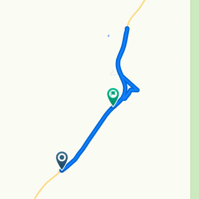
Vue d'ensemble
À propos du circuit
There are a couple of places to place a vehicle on this route to avoid having to ride the pavement back to the airport. This is a great ride, rugged in a few places andsome great climbs and downhills and well as some scenic detours. Bring plenty of water and snacks...it's a long ride.
- -:--
- Durée
- 28,4 km
- Distance
- 427 m
- Montée
- 430 m
- Descente
- ---
- Vit. moyenne
- ---
- Altitude max.
Points forts de l’itinéraire
Points d’intérêt le long de l’itinéraire
Point d'intérêt après 2,7 km
Paloma Canyon Turnoff
Point d'intérêt après 2,9 km
Point d'intérêt après 2,9 km
Gate...Please close the gate...
Point d'intérêt après 3,1 km
Junction..Right goes to old corrals and water tank and dead ends there...nice diversion..
Point d'intérêt après 4,7 km
Gate..Please close the gate..
Point d'intérêt après 4,7 km
This road just goes up the hill to a cattle tank and dead ends...it's still a good ride and a rugged climb
Point d'intérêt après 7,7 km
Old Corral...this is a good turnaround spot if you want to go back the way you came..from here the round trip is 9.5 miles....or continue..
Point d'intérêt après 8,7 km
great road...comes out just south of the runway...the gate is probably locked however
Point d'intérêt après 9 km
Great climb and beautiful view from top but is a dead end..although the view is worth the ride
Point d'intérêt après 12,8 km
Gate..Please close the gate
Point d'intérêt après 14,9 km
This is a great place to leave a vehicle if you want to end your ride here..otherwise it's on out to the Patagonia Hwy
Point d'intérêt après 15,9 km
Back entrance to Kino Springs via The Village
Point d'intérêt après 23,1 km
this also a good place to leave a vehicle if you want to end the ride here...otherwise..back to the airport
Continuer avec Bikemap
Utilise, modifie ou télécharge cet itinéraire vélo
Tu veux parcourir Airport to Harshaw Road loop and back to airport ou l’adapter à ton propre voyage ? Voici ce que tu peux faire avec cet itinéraire Bikemap :
Fonctionnalités gratuites
- Enregistre cet itinéraire comme favori ou dans une collection
- Copie et planifie ta propre version de cet itinéraire
- Synchronise ton itinéraire avec Garmin ou Wahoo
Fonctionnalités Premium
Essai gratuit de 3 jours, ou paiement unique. En savoir plus sur Bikemap Premium.
- Navigue sur cet itinéraire sur iOS et Android
- Exporter un fichier GPX / KML de cet itinéraire
- Crée ton impression personnalisée (essaie-la gratuitement)
- Télécharge cet itinéraire pour la navigation hors ligne
Découvre plus de fonctionnalités Premium.
Obtiens Bikemap PremiumDe notre communauté
Nogales : Autres itinéraires populaires qui commencent ici
 Airport to Harshaw Road loop and back to airport
- Distance
- 28,4 km
- Montée
- 427 m
- Descente
- 430 m
- Emplacement
- Nogales, Arizona, États Unis
 paloma canyon
- Distance
- 14,9 km
- Montée
- 333 m
- Descente
- 287 m
- Emplacement
- Nogales, Arizona, États Unis
 trecho yankee
- Distance
- 3 675,7 km
- Montée
- 9 362 m
- Descente
- 10 532 m
- Emplacement
- Nogales, Arizona, États Unis
 san2tume
- Distance
- 828,7 km
- Montée
- 2 759 m
- Descente
- 1 583 m
- Emplacement
- Nogales, Arizona, États Unis
 744–748 E Patagonia Hwy, Nogales to 900–958 E Patagonia Hwy, Nogales
- Distance
- 7,9 km
- Montée
- 1 279 m
- Descente
- 1 234 m
- Emplacement
- Nogales, Arizona, États Unis
Ouvre-la dans l’app