

Charlton Climb - New barn Hill 22er Loop
Un itinéraire vélo au départ de Fontwell, Angleterre, Royaume-Uni.
Vue d'ensemble
À propos du circuit
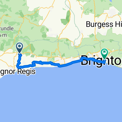
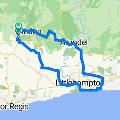
Départ au parking. Descente rapide vers Upwaltham, le long de Droke Lane, à travers East Dean jusqu'à Charlton. Montée à Knights Hill jusqu'à Trundle, bonne montée raide sur une route étroite. Descente rapide par Kennel Hill – accrochez-vous bien! Le long de New Road, puis au nord par New Barn Hill. Une de mes montées préférées. Elle commence à 27 mètres à 14 km et atteint 153 m à l'intersection. Tournez à droite sur Selhurstpark Road, mais ne vous attendez pas à ce que la montée s'arrête. La pente continue jusqu'à juste en dessous de la marque des 20 km. Maintenant à 179 m. Une montée de 153 m sur 6 km. La route Selhurstpark s'égalise finalement pour une belle finition de retour au parking. Un bon brûleur de jambes avec deux bonnes montées!
- -:--
- Durée
- 21,7 km
- Distance
- 274 m
- Montée
- 273 m
- Descente
- ---
- Vit. moyenne
- ---
- Altitude max.

Qualité de l’itinéraire
Types de voies et surfaces le long de l’itinéraire
Types de routes
Route
18,3 km
(84 %)
Route tranquille
2 km
(9 %)
Indéfini
1,5 km
(7 %)
surfaces
Pavé
8,5 km
(39 %)
Asphalte
8,5 km
(39 %)
Indéfini
13,3 km
(61 %)
Points forts de l’itinéraire
Points d’intérêt le long de l’itinéraire
Point d'intérêt après 0,1 km
Fast decent down A285 - good time to test your brakes!
Point d'intérêt après 8,1 km
Climb starts here at Charlton 64m climbing to 160m - 96m of ascent on very narrow tack. Keep an eye out for cars coming down and use passing bays.
Point d'intérêt après 10,3 km
Very fast decent
Point d'intérêt après 13,9 km
Start of good climb
Point d'intérêt après 17,6 km
At the top of New Barn Hill turn right into Selhurstpark Road but the climbing does not stop.
Continuer avec Bikemap
Utilise, modifie ou télécharge cet itinéraire vélo
Tu veux parcourir Charlton Climb - New barn Hill 22er Loop ou l’adapter à ton propre voyage ? Voici ce que tu peux faire avec cet itinéraire Bikemap :
Fonctionnalités gratuites
- Enregistre cet itinéraire comme favori ou dans une collection
- Copie et planifie ta propre version de cet itinéraire
- Synchronise ton itinéraire avec Garmin ou Wahoo
Fonctionnalités Premium
Essai gratuit de 3 jours, ou paiement unique. En savoir plus sur Bikemap Premium.
- Navigue sur cet itinéraire sur iOS et Android
- Exporter un fichier GPX / KML de cet itinéraire
- Crée ton impression personnalisée (essaie-la gratuitement)
- Télécharge cet itinéraire pour la navigation hors ligne
Découvre plus de fonctionnalités Premium.
Obtiens Bikemap PremiumDe notre communauté
Fontwell : Autres itinéraires populaires qui commencent ici
 1.hr Loop
- Distance
- 18,8 km
- Montée
- 299 m
- Descente
- 300 m
- Emplacement
- Fontwell, Angleterre, Royaume-Uni
 Wiggle MTB Epic
- Distance
- 64 km
- Montée
- 1 022 m
- Descente
- 1 027 m
- Emplacement
- Fontwell, Angleterre, Royaume-Uni
 Mac & Deb rounder
- Distance
- 29,8 km
- Montée
- 597 m
- Descente
- 596 m
- Emplacement
- Fontwell, Angleterre, Royaume-Uni
 West Walberton Lane, Arundel to Queen's Road, Brighton
- Distance
- 53,1 km
- Montée
- 111 m
- Descente
- 86 m
- Emplacement
- Fontwell, Angleterre, Royaume-Uni
 Slindon Bottom Road, Arundel to Slindon Bottom Road, Arundel
- Distance
- 34,7 km
- Montée
- 254 m
- Descente
- 254 m
- Emplacement
- Fontwell, Angleterre, Royaume-Uni
 Charlton Climb - New barn Hill 22er Loop
- Distance
- 21,7 km
- Montée
- 274 m
- Descente
- 273 m
- Emplacement
- Fontwell, Angleterre, Royaume-Uni
 Slindon - Arundel - Bury - Bignor - Upwaltham - Eartham - Slindon Circuit
- Distance
- 55,9 km
- Montée
- 861 m
- Descente
- 862 m
- Emplacement
- Fontwell, Angleterre, Royaume-Uni
 Foxfield, Slindon Bottom Road, Arundel to Foxfield, Slindon Bottom Road, Arundel
- Distance
- 20,9 km
- Montée
- 522 m
- Descente
- 520 m
- Emplacement
- Fontwell, Angleterre, Royaume-Uni
Ouvre-la dans l’app