

St Margaret's Way-Burntisland to Leven
Un itinéraire vélo au départ de Burntisland, Ecosse, Royaume-Uni.
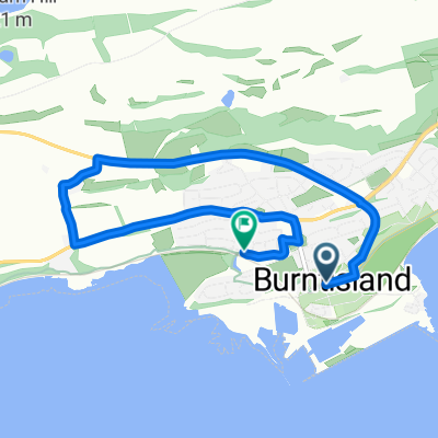
Vue d'ensemble
À propos du circuit
Going out Burntisland along a short strip of main road ,with a pedestrian walkway alongside, the Way returns to a quiet section of the Fife Coastal Path, past Kinghorn , where a Scottish king fell to his death, and onto Kirkcaldy, once the linoleum capital of Scotland . The path can become muddy as it skirts the coast. Across the water, the extinct volcanoes of the Bass Rock and North Berwick Law are visible.
Leaving Kirkcaldy and passing the grandly built old linoleum factory the Way descends abruptly to the beach, with the 15th century Ravenscraig Castle towering above. Then the Way follows the signposted Fife Coastal Path through former fishing and coalmining villages and past ancient buildings and memorials to Lundin Links and Leven.
This is the 3rd section of St Margaret’s Way, the great 100km pilgrimage trail from Edinburgh to St Andrews, part of the revival of the 1000 year old pilgrimage, The Way of St Andrews. (http://www.thewayofstandrews.com)
- -:--
- Durée
- 23,8 km
- Distance
- 126 m
- Montée
- 119 m
- Descente
- ---
- Vit. moyenne
- ---
- Altitude max.

Points forts de l’itinéraire
Points d’intérêt le long de l’itinéraire

Point d'intérêt après 7,3 km
This limestone bed was formed at the bottom of a warm shallow sea when this part of Scotland was near the Equator. Here the bed has been compressed horizontally so the hard limestone has cracked and one slab has slid over the other. This feature is called a thrust fault. More signs of volcanic activity lie just south of the breakwater. Here there is a reef formed by molten rock (basalt), which has squeezed between horizontal layers of sandstone. This feature is called a sill. Thanks to geoHeritage Fife for advice and image.
Continuer avec Bikemap
Utilise, modifie ou télécharge cet itinéraire vélo
Tu veux parcourir St Margaret's Way-Burntisland to Leven ou l’adapter à ton propre voyage ? Voici ce que tu peux faire avec cet itinéraire Bikemap :
Fonctionnalités gratuites
- Enregistre cet itinéraire comme favori ou dans une collection
- Copie et planifie ta propre version de cet itinéraire
- Synchronise ton itinéraire avec Garmin ou Wahoo
Fonctionnalités Premium
Essai gratuit de 3 jours, ou paiement unique. En savoir plus sur Bikemap Premium.
- Navigue sur cet itinéraire sur iOS et Android
- Exporter un fichier GPX / KML de cet itinéraire
- Crée ton impression personnalisée (essaie-la gratuitement)
- Télécharge cet itinéraire pour la navigation hors ligne
Découvre plus de fonctionnalités Premium.
Obtiens Bikemap PremiumDe notre communauté
Burntisland : Autres itinéraires populaires qui commencent ici
 BislLeuc
- Distance
- 59,8 km
- Montée
- 429 m
- Descente
- 418 m
- Emplacement
- Burntisland, Ecosse, Royaume-Uni
 Lengthy bike tour from カーコーディー to セントアンドリューズ
- Distance
- 52,2 km
- Montée
- 390 m
- Descente
- 492 m
- Emplacement
- Burntisland, Ecosse, Royaume-Uni
 InvkLeuc
- Distance
- 60,7 km
- Montée
- 464 m
- Descente
- 465 m
- Emplacement
- Burntisland, Ecosse, Royaume-Uni
 St Margaret's Way-Burntisland to Leven
- Distance
- 23,8 km
- Montée
- 126 m
- Descente
- 119 m
- Emplacement
- Burntisland, Ecosse, Royaume-Uni
 School 2
- Distance
- 5,3 km
- Montée
- 82 m
- Descente
- 89 m
- Emplacement
- Burntisland, Ecosse, Royaume-Uni
 Tour of the Kingdom Ride 130km route
- Distance
- 129 km
- Montée
- 792 m
- Descente
- 774 m
- Emplacement
- Burntisland, Ecosse, Royaume-Uni
 BIsCupar
- Distance
- 47,3 km
- Montée
- 369 m
- Descente
- 354 m
- Emplacement
- Burntisland, Ecosse, Royaume-Uni
Ouvre-la dans l’app