Views from the South Cycle Ride
Un itinéraire vélo au départ de Camberwell, Angleterre, Royaume-Uni.
Vue d'ensemble
À propos du circuit
Southwark Cyclists Promenade Santé
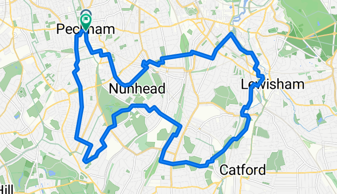
Départ à Peckham Square, à côté de la bibliothèque de Peckham et du centre de loisirs Peckham Pulse. Parcours de 19 km (11,5 miles) : Peckham - Dawson's Heights - Blythe Hill - Telegraph Hill – Peckham. Café à Ladywell Fields. Il y a 3 grosses côtes pour atteindre les points de vue et un total de 184 m de dénivelé, ce qui est plus que d'habitude. Principalement des rues calmes, quelques sentiers dans des parcs et une section de la Route Nationale 21. Temps estimé : 2,5 heures.
- 1 h 11 min
- Durée
- 18,4 km
- Distance
- 148 m
- Montée
- 145 m
- Descente
- 15,5 km/h
- Vit. moyenne
- 65 m
- Altitude max.
Qualité de l’itinéraire
Types de voies et surfaces le long de l’itinéraire
Types de routes
Route tranquille
10,1 km
(55 %)
Piste cyclable
3,7 km
(20 %)
surfaces
Pavé
14,4 km
(78 %)
Non pavé
0,4 km
(2 %)
Asphalte
13,8 km
(75 %)
Pavé (non défini)
0,6 km
(3 %)
Continuer avec Bikemap
Utilise, modifie ou télécharge cet itinéraire vélo
Tu veux parcourir Views from the South Cycle Ride ou l’adapter à ton propre voyage ? Voici ce que tu peux faire avec cet itinéraire Bikemap :
Fonctionnalités gratuites
- Enregistre cet itinéraire comme favori ou dans une collection
- Copie et planifie ta propre version de cet itinéraire
- Synchronise ton itinéraire avec Garmin ou Wahoo
Fonctionnalités Premium
Essai gratuit de 3 jours, ou paiement unique. En savoir plus sur Bikemap Premium.
- Navigue sur cet itinéraire sur iOS et Android
- Exporter un fichier GPX / KML de cet itinéraire
- Crée ton impression personnalisée (essaie-la gratuitement)
- Télécharge cet itinéraire pour la navigation hors ligne
Découvre plus de fonctionnalités Premium.
Obtiens Bikemap PremiumDe notre communauté
Camberwell : Autres itinéraires populaires qui commencent ici
 Round the parks ride
- Distance
- 15,8 km
- Montée
- 74 m
- Descente
- 73 m
- Emplacement
- Camberwell, Angleterre, Royaume-Uni
 Burgess Park to Holland Park and Brompton Cemetery
- Distance
- 24,3 km
- Montée
- 85 m
- Descente
- 84 m
- Emplacement
- Camberwell, Angleterre, Royaume-Uni
 London to Brighton
- Distance
- 88,1 km
- Montée
- 467 m
- Descente
- 486 m
- Emplacement
- Camberwell, Angleterre, Royaume-Uni
 Ravensbourne and Wandle Circular
- Distance
- 51,6 km
- Montée
- 167 m
- Descente
- 165 m
- Emplacement
- Camberwell, Angleterre, Royaume-Uni
 Moderate route in London
- Distance
- 11,4 km
- Montée
- 0 m
- Descente
- 3 m
- Emplacement
- Camberwell, Angleterre, Royaume-Uni
 SE London 2
- Distance
- 49,6 km
- Montée
- 250 m
- Descente
- 250 m
- Emplacement
- Camberwell, Angleterre, Royaume-Uni
 Kent/Surrey borders route from East Dulwich
- Distance
- 66,9 km
- Montée
- 632 m
- Descente
- 593 m
- Emplacement
- Camberwell, Angleterre, Royaume-Uni
 Circular Route from SE London
- Distance
- 91,5 km
- Montée
- 465 m
- Descente
- 467 m
- Emplacement
- Camberwell, Angleterre, Royaume-Uni
Ouvre-la dans l’app

