

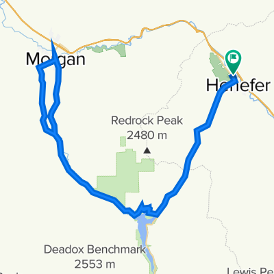
CROYDON DEATH LOOP
Un itinéraire vélo au départ de Coalville, Utah, États Unis.
Vue d'ensemble
À propos du circuit
Une boucle de cyclisme courte mais modérée avec une diversité intéressante. Environ 11 miles avec un gain d'élévation d'environ 650 pieds.
AVERTISSEMENT : ENVIRON 1,5 MILES DE CETTE BOUCLE SONT SUR L'I-15. IL VOUS INDIQUE DE RECHERCHER UNE BONNE EXPLICATION (POUR UN TROUPE DE L'ÉTAT DE L'UTAH) EXPLIQUANT POURQUOI C'EST LÉGAL. Il est recommandé de faire cette boucle dans le sens des aiguilles d'une montre pour que le tronçon de l'autoroute soit en descente.
Il n'y a pas de commodités sur l'itinéraire, même à Henefer. Il pourrait y avoir quelques endroits où vous pouvez trouver de l'eau de fossé si nécessaire, mais rien de potable.
Votre sortie peut être prolongée en ajoutant un aller-retour depuis Croydon en direction du réservoir de Lost Creek.
- -:--
- Durée
- 17,3 km
- Distance
- ---
- Montée
- ---
- Descente
- ---
- Vit. moyenne
- ---
- Altitude max.

Continuer avec Bikemap
Utilise, modifie ou télécharge cet itinéraire vélo
Tu veux parcourir CROYDON DEATH LOOP ou l’adapter à ton propre voyage ? Voici ce que tu peux faire avec cet itinéraire Bikemap :
Fonctionnalités gratuites
- Enregistre cet itinéraire comme favori ou dans une collection
- Copie et planifie ta propre version de cet itinéraire
- Synchronise ton itinéraire avec Garmin ou Wahoo
Fonctionnalités Premium
Essai gratuit de 3 jours, ou paiement unique. En savoir plus sur Bikemap Premium.
- Navigue sur cet itinéraire sur iOS et Android
- Exporter un fichier GPX / KML de cet itinéraire
- Crée ton impression personnalisée (essaie-la gratuitement)
- Télécharge cet itinéraire pour la navigation hors ligne
Découvre plus de fonctionnalités Premium.
Obtiens Bikemap PremiumDe notre communauté
Coalville : Autres itinéraires populaires qui commencent ici
 Wanship-Kamas Valley
- Distance
- 72,6 km
- Montée
- 347 m
- Descente
- 362 m
- Emplacement
- Coalville, Utah, États Unis
 CROYDON DEATH LOOP
- Distance
- 17,3 km
- Montée
- ---
- Descente
- ---
- Emplacement
- Coalville, Utah, États Unis
 Wanship to Echo
- Distance
- 19,9 km
- Montée
- 110 m
- Descente
- 24 m
- Emplacement
- Coalville, Utah, États Unis
 Coalville Cycling
- Distance
- 68,6 km
- Montée
- 1 395 m
- Descente
- 1 127 m
- Emplacement
- Coalville, Utah, États Unis
 Coalville Cycling
- Distance
- 65 km
- Montée
- 303 m
- Descente
- 293 m
- Emplacement
- Coalville, Utah, États Unis
 Pioneer Drive to Pioneer Drive
- Distance
- 96,6 km
- Montée
- 542 m
- Descente
- 522 m
- Emplacement
- Coalville, Utah, États Unis
 North Uinta
- Distance
- 297,4 km
- Montée
- 2 692 m
- Descente
- 2 770 m
- Emplacement
- Coalville, Utah, États Unis
 Browns Cyn - Echo Res.
- Distance
- 88,3 km
- Montée
- 788 m
- Descente
- 709 m
- Emplacement
- Coalville, Utah, États Unis
Ouvre-la dans l’app