

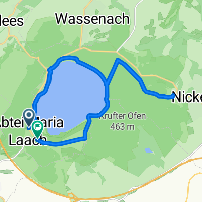
Easy Sonntagsrunde 2x um den Laacher See
Un itinéraire vélo au départ de Bell, Rhineland-Palatinate, Germany.
Vue d'ensemble
À propos du circuit
Start/Ende am Parkplatz am Kloster.
Ist für Anfänger genau richtig, nicht zuviele Höhenmeter.
- -:--
- Durée
- 19,5 km
- Distance
- 363 m
- Montée
- 363 m
- Descente
- ---
- Vit. moyenne
- ---
- Altitude max.
Continuer avec Bikemap
Utilise, modifie ou télécharge cet itinéraire vélo
Tu veux parcourir Easy Sonntagsrunde 2x um den Laacher See ou l’adapter à ton propre voyage ? Voici ce que tu peux faire avec cet itinéraire Bikemap :
Fonctionnalités gratuites
- Enregistre cet itinéraire comme favori ou dans une collection
- Copie et planifie ta propre version de cet itinéraire
- Synchronise ton itinéraire avec Garmin ou Wahoo
Fonctionnalités Premium
Essai gratuit de 3 jours, ou paiement unique. En savoir plus sur Bikemap Premium.
- Navigue sur cet itinéraire sur iOS et Android
- Exporter un fichier GPX / KML de cet itinéraire
- Crée ton impression personnalisée (essaie-la gratuitement)
- Télécharge cet itinéraire pour la navigation hors ligne
Découvre plus de fonctionnalités Premium.
Obtiens Bikemap PremiumDe notre communauté
Bell : Autres itinéraires populaires qui commencent ici
 Gänsehals Hochstein Hochsimmer
- Distance
- 29,9 km
- Montée
- 931 m
- Descente
- 847 m
- Emplacement
- Bell, Rhineland-Palatinate, Germany
 Laacher See-Hönningen
- Distance
- 54,2 km
- Montée
- 483 m
- Descente
- 546 m
- Emplacement
- Bell, Rhineland-Palatinate, Germany
 Hochstein
- Distance
- 20,9 km
- Montée
- 526 m
- Descente
- 526 m
- Emplacement
- Bell, Rhineland-Palatinate, Germany
 Maria Laach fietstocht
- Distance
- 18,9 km
- Montée
- 353 m
- Descente
- 353 m
- Emplacement
- Bell, Rhineland-Palatinate, Germany
 Hochsimmer
- Distance
- 20,1 km
- Montée
- 622 m
- Descente
- 622 m
- Emplacement
- Bell, Rhineland-Palatinate, Germany
 Höhenweg 1:17
- Distance
- 20,8 km
- Montée
- 387 m
- Descente
- 437 m
- Emplacement
- Bell, Rhineland-Palatinate, Germany
 Laacher Vulkan See
- Distance
- 14,2 km
- Montée
- 324 m
- Descente
- 319 m
- Emplacement
- Bell, Rhineland-Palatinate, Germany
 In den Forstwiesen 17, Bell nach In den Forstwiesen 17, Bell
- Distance
- 47,3 km
- Montée
- 337 m
- Descente
- 347 m
- Emplacement
- Bell, Rhineland-Palatinate, Germany
Ouvre-la dans l’app