

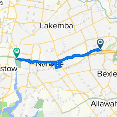
(Map 3D) M5 Linear Park to Bexley Pool
Un itinéraire vélo au départ de Bexley North, Nouvelle-Galles du Sud, Australie.
Vue d'ensemble
À propos du circuit
Cette carte est à des fins de planification et n'existe actuellement pas.
Cet itinéraire se rapporte aux mises à niveau suggérées pour (Carte 3) que le Conseil de Bayside et le Gouvernement de NSW sont priés de réaliser.
Les caractéristiques incluent :
- Un nouveau tunnel ou pont pour relier le M5 Linear Park à Kookaburra Lane.
- Un ATL le long de Bardwell Creek à travers des terrains vacants.
- Utilisation de Preddys Lane et des terrains du Conseil pour se connecter avec Highgate St.
- 11 min
- Durée
- 2,7 km
- Distance
- 32 m
- Montée
- 16 m
- Descente
- 15 km/h
- Vit. moyenne
- 44 m
- Altitude max.

Continuer avec Bikemap
Utilise, modifie ou télécharge cet itinéraire vélo
Tu veux parcourir (Map 3D) M5 Linear Park to Bexley Pool ou l’adapter à ton propre voyage ? Voici ce que tu peux faire avec cet itinéraire Bikemap :
Fonctionnalités gratuites
- Enregistre cet itinéraire comme favori ou dans une collection
- Copie et planifie ta propre version de cet itinéraire
- Synchronise ton itinéraire avec Garmin ou Wahoo
Fonctionnalités Premium
Essai gratuit de 3 jours, ou paiement unique. En savoir plus sur Bikemap Premium.
- Navigue sur cet itinéraire sur iOS et Android
- Exporter un fichier GPX / KML de cet itinéraire
- Crée ton impression personnalisée (essaie-la gratuitement)
- Télécharge cet itinéraire pour la navigation hors ligne
Découvre plus de fonctionnalités Premium.
Obtiens Bikemap PremiumDe notre communauté
Bexley North : Autres itinéraires populaires qui commencent ici
 (Map 3D) M5 Linear Park to Bexley Pool
- Distance
- 2,7 km
- Montée
- 32 m
- Descente
- 16 m
- Emplacement
- Bexley North, Nouvelle-Galles du Sud, Australie
 cooks River home loop
- Distance
- 10,2 km
- Montée
- 146 m
- Descente
- 139 m
- Emplacement
- Bexley North, Nouvelle-Galles du Sud, Australie
 Miller Avenue 16, Bexley North to Golden Vale Road, Sutton Forest
- Distance
- 132 km
- Montée
- 2 182 m
- Descente
- 1 566 m
- Emplacement
- Bexley North, Nouvelle-Galles du Sud, Australie
 9 Calbina Road, Earlwood to 13 Calbina Road, Earlwood
- Distance
- 22,6 km
- Montée
- 34 m
- Descente
- 57 m
- Emplacement
- Bexley North, Nouvelle-Galles du Sud, Australie
 Bexley Rd, Kingsgrove to 3 The Crescent, Kingsgrove
- Distance
- 4,7 km
- Montée
- 30 m
- Descente
- 18 m
- Emplacement
- Bexley North, Nouvelle-Galles du Sud, Australie
 Bexley North to Salt Pan Creek Reserve (M5 East Tunnel Cycleway)
- Distance
- 8,4 km
- Montée
- 54 m
- Descente
- 67 m
- Emplacement
- Bexley North, Nouvelle-Galles du Sud, Australie
 Bexley North to Cooks River
- Distance
- 3,7 km
- Montée
- 32 m
- Descente
- 45 m
- Emplacement
- Bexley North, Nouvelle-Galles du Sud, Australie
 Clemton Park to Lakemba
- Distance
- 3,4 km
- Montée
- 44 m
- Descente
- 29 m
- Emplacement
- Bexley North, Nouvelle-Galles du Sud, Australie
Ouvre-la dans l’app