

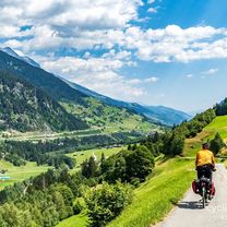
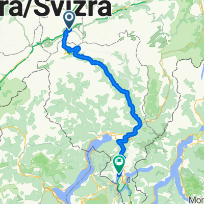
Vue d'ensemble
À propos du circuit
- 6 h 54 min
- Durée
- 100,6 km
- Distance
- 1 906 m
- Montée
- 3 728 m
- Descente
- 14,6 km/h
- Vit. moyenne
- 2 111 m
- Altitude max.
Partie de
2025_ALPX
8 étapes
Qualité de l’itinéraire
Types de voies et surfaces le long de l’itinéraire
Types de routes
Route tranquille
27,2 km
(27 %)
Sentier
12,1 km
(12 %)
surfaces
Pavé
58,3 km
(58 %)
Non pavé
16,1 km
(16 %)
Asphalte
57,3 km
(57 %)
Sol
11,1 km
(11 %)
Points forts de l’itinéraire
Points d’intérêt le long de l’itinéraire
Eau potable après 12,9 km
Eau potable après 21,2 km
Eau potable après 26,7 km
Eau potable après 34,1 km
Eau potable après 34,4 km
Eau potable après 39,8 km
Eau potable après 39,9 km
Eau potable après 40,2 km
Eau potable après 47,8 km
Eau potable après 48,4 km
Eau potable après 54,4 km
Eau potable après 59,8 km
Eau potable après 64 km
Eau potable après 70,1 km
Eau potable après 74,5 km
Eau potable après 77,7 km
Eau potable après 77,9 km
Eau potable après 82,4 km
Eau potable après 87,2 km
Eau potable après 87,8 km
Eau potable après 92,6 km
Continuer avec Bikemap
Utilise, modifie ou télécharge cet itinéraire vélo
Tu veux parcourir V2_E07_ALPX_Schweiz ou l’adapter à ton propre voyage ? Voici ce que tu peux faire avec cet itinéraire Bikemap :
Fonctionnalités gratuites
- Enregistre cet itinéraire comme favori ou dans une collection
- Copie et planifie ta propre version de cet itinéraire
- Divise-le en étapes pour créer un tour sur plusieurs jours
- Synchronise ton itinéraire avec Garmin ou Wahoo
Fonctionnalités Premium
Essai gratuit de 3 jours, ou paiement unique. En savoir plus sur Bikemap Premium.
- Navigue sur cet itinéraire sur iOS et Android
- Exporter un fichier GPX / KML de cet itinéraire
- Crée ton impression personnalisée (essaie-la gratuitement)
- Télécharge cet itinéraire pour la navigation hors ligne
Découvre plus de fonctionnalités Premium.
Obtiens Bikemap PremiumDe notre communauté
Andermatt : Autres itinéraires populaires qui commencent ici
 VR01 Furkapass Belvedere-Brig.kml - VR01 Furkapass Belvedere-Brig.kml_VR01 Furkapass Belvedere-Brig
- Distance
- 60,1 km
- Montée
- 852 m
- Descente
- 2 409 m
- Emplacement
- Andermatt, Canton d’Uri, Suisse
 Rheinradweg
- Distance
- 1 085,7 km
- Montée
- 107 m
- Descente
- 1 544 m
- Emplacement
- Andermatt, Canton d’Uri, Suisse
 NL The Rhine Cycle Route
- Distance
- 1 352,1 km
- Montée
- 88 m
- Descente
- 1 523 m
- Emplacement
- Andermatt, Canton d’Uri, Suisse
 Furka-Nufenen-Gotthard-Oberalp
- Distance
- 135,9 km
- Montée
- 4 637 m
- Descente
- 4 527 m
- Emplacement
- Andermatt, Canton d’Uri, Suisse
 Rhine Cycle Route, EuroVelo 15 - Andermatt to Basel
- Distance
- 492,2 km
- Montée
- 6 424 m
- Descente
- 7 590 m
- Emplacement
- Andermatt, Canton d’Uri, Suisse
 giro dei tre passi susten grimsel furka
- Distance
- 132,9 km
- Montée
- 3 457 m
- Descente
- 3 601 m
- Emplacement
- Andermatt, Canton d’Uri, Suisse
 Andermatt 3
- Distance
- 158,9 km
- Montée
- 3 905 m
- Descente
- 3 702 m
- Emplacement
- Andermatt, Canton d’Uri, Suisse
 Bellinzona - Vizzola Ticino
- Distance
- 130,7 km
- Montée
- 2 639 m
- Descente
- 3 799 m
- Emplacement
- Andermatt, Canton d’Uri, Suisse
Ouvre-la dans l’app