

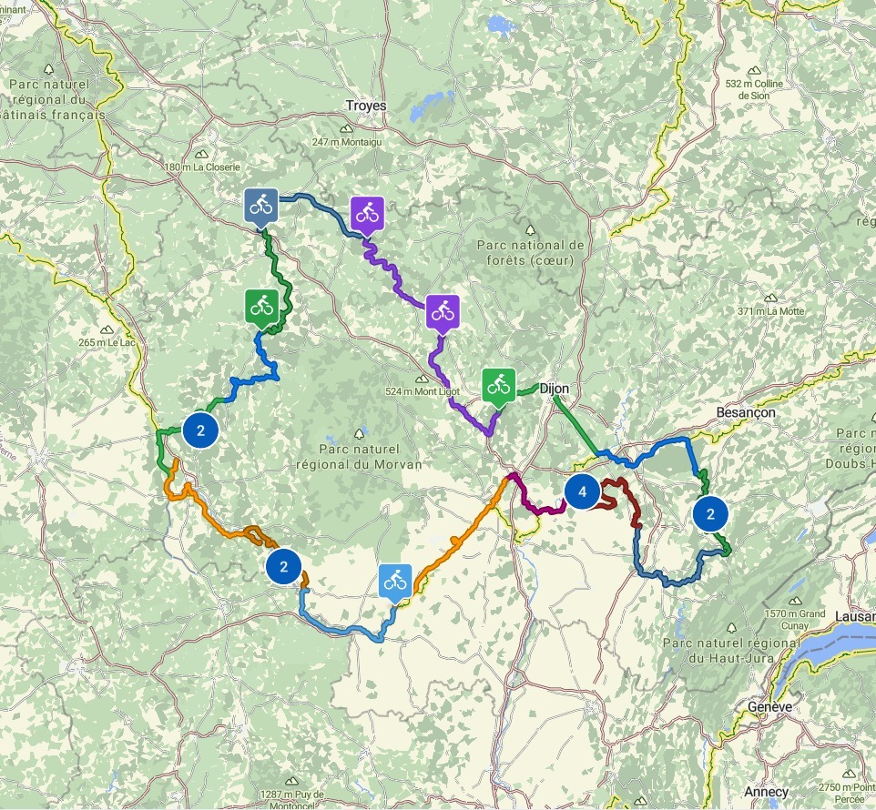
FR2
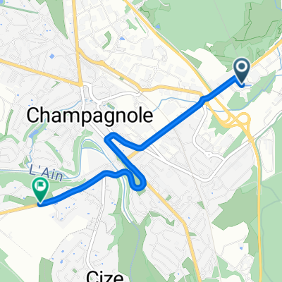
FR2-13d_Champagnole_Chaumergy_80,5km 410km
Un itinéraire vélo au départ de Champagnole, Bourgogne-Franche-Comté, France.
Vue d'ensemble
À propos du circuit
- 4 h 58 min
- Durée
- 79,4 km
- Distance
- 532 m
- Montée
- 857 m
- Descente
- 16 km/h
- Vit. moyenne
- 546 m
- Altitude max.

Partie de
16 étapes
Qualité de l’itinéraire
Types de voies et surfaces le long de l’itinéraire
Types de routes
Sentier
29,4 km
(37 %)
Piste cyclable
20,6 km
(26 %)
surfaces
Pavé
62,7 km
(79 %)
Non pavé
10,3 km
(13 %)
Asphalte
62,7 km
(79 %)
Gravier meuble
8,7 km
(11 %)
Points forts de l’itinéraire
Points d’intérêt le long de l’itinéraire
Réparation vélo après 0 km
Cycles du Chateau d'Eau
Point d'intérêt après 0,1 km
Toilette
Point d'intérêt après 0,2 km
Bank
Point d'intérêt après 0,2 km
Bank
Point d'intérêt après 0,2 km
Bank
Eau potable après 0,2 km
Bäckerei La Grange aux Pains
Eau potable après 0,6 km
Bäckerei La Main à la Pâte
Eau potable après 0,7 km
Super U
Point d'intérêt après 1,4 km
Bank
Point d'intérêt après 1,5 km
Voie PLM (Bahngesellschaft Paris-Lyon-Mediterranee)
Point d'intérêt après 9,8 km
Bänke
Point d'intérêt après 9,8 km
Église Saint-Pierre
Point d'intérêt après 9,9 km
Bank
Point d'intérêt après 10 km
Brunnen
Point d'intérêt après 12,5 km
Bank
Point d'intérêt après 13,1 km
Bank
Point d'intérêt après 13,9 km
Bank
Point d'intérêt après 14,1 km
Bank
Point d'intérêt après 14,1 km
Der Mittelabschnitt des PLM-Radwegs von Pont-du-Navoy bis Chatillon ist noch nicht fertig ausgebaut - Der Weg führt über Straßen und am Bade-See "Lac de Chalain" vorbei
Eau potable après 14,4 km
Bäckerei La Gustative
Point d'intérêt après 14,5 km
Pont-du-Navoy
Point d'intérêt après 16,1 km
Bank
Point d'intérêt après 16,4 km
Kirchhof der Église Saint-Maurice
Point d'intérêt après 17,5 km
Bank
Point d'intérêt après 19,9 km
Bank
Point d'intérêt après 20,3 km
Toilette
Point d'intérêt après 20,3 km
Rastplatz
Point d'intérêt après 20,4 km
Hier treffen wir auf den VPGTJ (Voie P'tite GTJ), einer Fortsetzung des Radweg GTJ (Grand Tour de Jura) und folgen ihm
Point d'intérêt après 21 km
Eiscafe La Pergola - der Strand ist möglicherweise auf der Südseite des Sees ruhiger und schöner
Point d'intérêt après 21 km
Toilette
Point d'intérêt après 21 km
Badestrand
Point d'intérêt après 22,7 km
Wenn bereits gebadet - dann geradeaus weiter fahren
Point d'intérêt après 23,8 km
Toilette
Point d'intérêt après 23,9 km
Badestrand Plage de Doucier
Point d'intérêt après 24,1 km
Toilette
Point d'intérêt après 28,2 km
Brücke über den Ain
Point d'intérêt après 29,7 km
Bank
Point d'intérêt après 29,9 km
Bei Châtillon beginnt der PLM wieder und vereinigt V587 und VPGTJ: P'tite GTJ a velo
Point d'intérêt après 31,2 km
Ehemalige Brücke über die PLM
Point d'intérêt après 32,1 km
Radweg Voie Verte PLM - mit beleuchteten Tunneln
Point d'intérêt après 34,2 km
Wenn man rein fährt, ist es noch dunkel! - Dann wird es hell
Point d'intérêt après 34,4 km
Eine Welt für sich
Point d'intérêt après 35,2 km
Bänke
Point d'intérêt après 36,6 km
PLM Radweg
Point d'intérêt après 39,9 km
Entweder geradeaus fahren (wenn es geht) oder links abbiegen, dann rechts und wieder links. Geradeaus wäre auf jeden Fall besser, da bei der alternativen Strecke am Ende eine Treppe bewältigt werden muss, um wieder auf den PLM zu kommen!
Point d'intérêt après 40,8 km
Gallerie du Faite
Point d'intérêt après 40,8 km
Ab hier ist die PLM-Route auf Komoot als gesperrt markiert
Point d'intérêt après 41,1 km
Treppen, um auf die Bahntrasse zurück zu kommen
Point d'intérêt après 41,2 km
Blick auf das Tal von La Vallière
Point d'intérêt après 41,3 km
Bank
Point d'intérêt après 41,4 km
Révigny Metallviadukt
Point d'intérêt après 41,4 km
Pont de Guillotine
Point d'intérêt après 41,5 km
Belvédère de la Guillotine
Point d'intérêt après 41,5 km
Tunnel de Guillotine
Point d'intérêt après 41,6 km
Tunnel de Revigny
Point d'intérêt après 42,7 km
Bank
Point d'intérêt après 43,1 km
Tunnel des Tilleuls
Point d'intérêt après 43,4 km
Bank
Point d'intérêt après 43,9 km
Tunnel de la Diane (PLM-Strecke)
Point d'intérêt après 44,7 km
Bank
Point d'intérêt après 45,2 km
Bank
Point d'intérêt après 45,4 km
Bank
Point d'intérêt après 45,7 km
Conliege Gare
Point d'intérêt après 45,8 km
Bänke und Rastplätze
Point d'intérêt après 46,3 km
Bank
Point d'intérêt après 46,4 km
Aussichtspunkt
Point d'intérêt après 46,5 km
Bank
Point d'intérêt après 46,9 km
Bank
Point d'intérêt après 46,9 km
Bank
Point d'intérêt après 47,1 km
Bank
Point d'intérêt après 47,7 km
Ancienne église Saint-Jean-Baptiste
Réparation vélo après 48,3 km
Planete Velo
Eau potable après 49,5 km
Le rendez-vous des Gourmands Bäckerei
Point d'intérêt après 49,6 km
Toilette
Point d'intérêt après 49,6 km
Toilette
Réparation vélo après 50,6 km
Velo Qui Rir
Point d'intérêt après 50,7 km
Bank
Point d'intérêt après 51 km
Bank
Point d'intérêt après 51,1 km
Bank
Point d'intérêt après 51,1 km
Rastplatz
Point d'intérêt après 51,6 km
Toilette
Point d'intérêt après 52,1 km
Viele Bänke
Point d'intérêt après 52,1 km
Bank
Point d'intérêt après 52,3 km
Toilette
Point d'intérêt après 52,4 km
Statue de Rouget de Lisle - Claude Joseph Rouget de Lisle oder Claude Joseph Rouget de l’Isle, geboren als Claude Joseph Rouget (* 10. Mai 1760 in Lons-le-Saunier; † 26. Juni 1836 in Choisy-le-Roi) war ein französischer Komponist, Dichter und Offizier. Er dichtete und komponierte in der Nacht vom 25. auf den 26. April 1792 während der Kriegserklärung an Österreich im elsässischen Straßburg das Kriegslied der französischen Rheinarmee Chant de guerre pour l’armée du Rhin, das dann später unter der Bezeichnung Marseillaise zum Revolutionslied wurde. Sechs Jahre nach dem Sturm auf die Bastille wurde die Marseillaise am 14. Juli 1795 zur Nationalhymne erklärt, in den folgenden Jahren während des Kaiserreichs und der Restaurationsepoche mehrmals verboten und erst nach der Julirevolution von 1830 wieder anerkannt.
Point d'intérêt après 52,5 km
Viele Bänke
Point d'intérêt après 52,7 km
Bank
Point d'intérêt après 52,7 km
Bank
Point d'intérêt après 52,7 km
Bank
Point d'intérêt après 53,1 km
Église Saint-Désiré
Eau potable après 53,1 km
Boulangerie Mathieu Paget
Réparation vélo après 53,3 km
Cycles Fachinetti
Point d'intérêt après 53,3 km
Bank
Point d'intérêt après 53,3 km
Bank
Point d'intérêt après 54,1 km
La Voie Bressane
Point d'intérêt après 54,7 km
Bank
Point d'intérêt après 55,1 km
Bank
Point d'intérêt après 55,4 km
Bank
Réparation vélo après 55,5 km
Mondovelo
Point d'intérêt après 55,9 km
Bank
Point d'intérêt après 56,4 km
Bank
Point d'intérêt après 57,1 km
Bank
Point d'intérêt après 57,1 km
Bank
Point d'intérêt après 57,4 km
La Vallière
Point d'intérêt après 57,7 km
Bank
Point d'intérêt après 58,2 km
Rastplatz
Réparation vélo après 58,2 km
Relais Velo
Point d'intérêt après 58,3 km
Bank
Point d'intérêt après 58,3 km
Voie La Bresse Jurassienne
Point d'intérêt après 59 km
Bank - die letzte für eine Weile
Point d'intérêt après 67,1 km
Bänke
Point d'intérêt après 67,1 km
Église de la Conversion-de-Saint-Paul
Point d'intérêt après 67,2 km
Bank
Point d'intérêt après 67,3 km
Bank
Point d'intérêt après 67,8 km
Bank
Point d'intérêt après 67,8 km
V587: Tour du Jura Loisiers
Point d'intérêt après 68,7 km
La Seille
Point d'intérêt après 68,9 km
Alter Bahnhof Bletterans
Point d'intérêt après 69,3 km
Canal de Moulins
Point d'intérêt après 70,6 km
Bank
Point d'intérêt après 70,6 km
Etang Neuf
Point d'intérêt après 70,6 km
Bahnwärterhaus
Point d'intérêt après 70,7 km
Bank - Baden???
Point d'intérêt après 75 km
Joli Ponton
Point d'intérêt après 76,2 km
Rastplatz
Point d'intérêt après 76,6 km
Rastplatz
Point d'intérêt après 76,8 km
Rastplatz
Point d'intérêt après 77,9 km
Bank
Point d'intérêt après 78,3 km
Bank
Point d'intérêt après 78,8 km
Bank
Hébergement après 79,4 km
Continuer avec Bikemap
Utilise, modifie ou télécharge cet itinéraire vélo
Tu veux parcourir FR2-13d_Champagnole_Chaumergy_80,5km 410km ou l’adapter à ton propre voyage ? Voici ce que tu peux faire avec cet itinéraire Bikemap :
Fonctionnalités gratuites
- Enregistre cet itinéraire comme favori ou dans une collection
- Copie et planifie ta propre version de cet itinéraire
- Synchronise ton itinéraire avec Garmin ou Wahoo
Fonctionnalités Premium
Essai gratuit de 3 jours, ou paiement unique. En savoir plus sur Bikemap Premium.
- Navigue sur cet itinéraire sur iOS et Android
- Exporter un fichier GPX / KML de cet itinéraire
- Crée ton impression personnalisée (essaie-la gratuitement)
- Télécharge cet itinéraire pour la navigation hors ligne
Découvre plus de fonctionnalités Premium.
Obtiens Bikemap PremiumDe notre communauté
Champagnole : Autres itinéraires populaires qui commencent ici
 Champagnole - Digione
- Distance
- 110,9 km
- Montée
- 329 m
- Descente
- 616 m
- Emplacement
- Champagnole, Bourgogne-Franche-Comté, France
 C60+5_Vaudioux-Fleurier_Variante_1_komoot_71_1160
- Distance
- 71,1 km
- Montée
- 1 389 m
- Descente
- 1 280 m
- Emplacement
- Champagnole, Bourgogne-Franche-Comté, France
 FR2-13d_Champagnole_Chaumergy_80,5km 410km
- Distance
- 79,4 km
- Montée
- 532 m
- Descente
- 857 m
- Emplacement
- Champagnole, Bourgogne-Franche-Comté, France
 COP' Jura - 3ème étape
- Distance
- 128,8 km
- Montée
- 1 548 m
- Descente
- 1 178 m
- Emplacement
- Champagnole, Bourgogne-Franche-Comté, France
 7. Champagnole - Lons le Saunier
- Distance
- 60 km
- Montée
- 424 m
- Descente
- 690 m
- Emplacement
- Champagnole, Bourgogne-Franche-Comté, France
 Freiburg - Nimes | Teil 3: Champagnole - Lyon
- Distance
- 143,9 km
- Montée
- 619 m
- Descente
- 1 055 m
- Emplacement
- Champagnole, Bourgogne-Franche-Comté, France
 idee 2010 burgund: 2b champagnole - louhan - chalon
- Distance
- 123,8 km
- Montée
- 330 m
- Descente
- 683 m
- Emplacement
- Champagnole, Bourgogne-Franche-Comté, France
 7. champagnole - lons le saunier
- Distance
- 3,2 km
- Montée
- 55 m
- Descente
- 66 m
- Emplacement
- Champagnole, Bourgogne-Franche-Comté, France
Ouvre-la dans l’app