

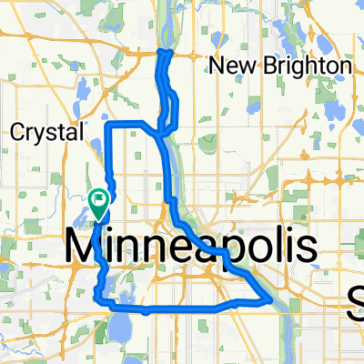
Theo Wirth Area MTB Trails
Un itinéraire vélo au départ de Golden Valley, Minnesota, États Unis.
Vue d'ensemble
À propos du circuit
C'est un bon parcours VTT qui emprunte tous les sentiers de terre dans la région de Theo Wirth. Il commence à Robbinsdale et descend vers le sud jusqu'au lac Cedar, puis revient en boucle. Il y a un bon mélange de sentiers en terre et goudronnés.
- -:--
- Durée
- 14,8 km
- Distance
- 81 m
- Montée
- 93 m
- Descente
- ---
- Vit. moyenne
- ---
- Altitude max.
Points forts de l’itinéraire
Points d’intérêt le long de l’itinéraire
Point d'intérêt après 0 km
This is the parking lot for the Mary Hills Park. There is a field right next to the parking lot. The single track starts at the southern end of this field and goes all the way through the park down to Golden Valley Road. Cross Golden Valley Road and another trail picks up right next to the golf course. Look out for walkers.
Point d'intérêt après 1,1 km
Sweet dirt jump area!
Point d'intérêt après 2,1 km
This trail is short but fun. It is much better coming from the north and heading south. Look out for walkers.
Point d'intérêt après 3,5 km
Theo Wirth Singletrack North Loop Entrance.
Point d'intérêt après 3,8 km
Theo Wirth Singletrack South Loop Entrance.
Point d'intérêt après 4,3 km
This is a nice quick little single track that leads down to the paved trail that goes around Wirth Lake. Once you hit the paved trail, go to your right and look for a single track trail exit on your right. This will lead you back out to Wirth Parkway where you can cross the street and the trail continues.
Point d'intérêt après 5 km
This is a fun little trail that offers a steep climb if heading south and a fun downhill with a nice drop if heading north.
Point d'intérêt après 6,8 km
Check out the very technical Brownie Lake singletrack in these woods. Lots of quick ups and downs.
Point d'intérêt après 8,7 km
This is a nice little secluded area with some good dirt jumps and lots of trails intersecting. Look out for walkers through here though. Technically bikes are not allowed on these trails but people do not seem to mind as long your not speeding through here. There is also an older technical trail with a teeter totter and some log piles right next to the train tracks.
Point d'intérêt après 9,7 km
This area as well as the Cedar Lake area has a ton of older trails. They are nothing to write home about but fun to explore.
Point d'intérêt après 11,3 km
There are some more older trails and berms in here. These are the Hobo Camp trails.
Continuer avec Bikemap
Utilise, modifie ou télécharge cet itinéraire vélo
Tu veux parcourir Theo Wirth Area MTB Trails ou l’adapter à ton propre voyage ? Voici ce que tu peux faire avec cet itinéraire Bikemap :
Fonctionnalités gratuites
- Enregistre cet itinéraire comme favori ou dans une collection
- Copie et planifie ta propre version de cet itinéraire
- Synchronise ton itinéraire avec Garmin ou Wahoo
Fonctionnalités Premium
Essai gratuit de 3 jours, ou paiement unique. En savoir plus sur Bikemap Premium.
- Navigue sur cet itinéraire sur iOS et Android
- Exporter un fichier GPX / KML de cet itinéraire
- Crée ton impression personnalisée (essaie-la gratuitement)
- Télécharge cet itinéraire pour la navigation hors ligne
Découvre plus de fonctionnalités Premium.
Obtiens Bikemap PremiumDe notre communauté
Golden Valley : Autres itinéraires populaires qui commencent ici
 Loop 5/20/20
- Distance
- 14,8 km
- Montée
- 95 m
- Descente
- 93 m
- Emplacement
- Golden Valley, Minnesota, États Unis
 edina route66
- Distance
- 46,2 km
- Montée
- 116 m
- Descente
- 117 m
- Emplacement
- Golden Valley, Minnesota, États Unis
 B2B00088 55411 > 55111 via downtown, Light Rail trail, and Minnehaha park
- Distance
- 18,8 km
- Montée
- 39 m
- Descente
- 95 m
- Emplacement
- Golden Valley, Minnesota, États Unis
 Theo Wirth Area MTB Trails
- Distance
- 14,8 km
- Montée
- 81 m
- Descente
- 93 m
- Emplacement
- Golden Valley, Minnesota, États Unis
 Luce around Minnetonka
- Distance
- 80 km
- Montée
- 145 m
- Descente
- 138 m
- Emplacement
- Golden Valley, Minnesota, États Unis
 44 Mile Tour D'Amico
- Distance
- 66,9 km
- Montée
- 201 m
- Descente
- 201 m
- Emplacement
- Golden Valley, Minnesota, États Unis
 Trip to Wayzata
- Distance
- 18,8 km
- Montée
- 108 m
- Descente
- 76 m
- Emplacement
- Golden Valley, Minnesota, États Unis
 B2B00321 55442>55411 via Culver Rd, Kyle Ave, Theo Wirth Pkwy & Plymouth Ave
- Distance
- 5 km
- Montée
- 37 m
- Descente
- 37 m
- Emplacement
- Golden Valley, Minnesota, États Unis
Ouvre-la dans l’app