

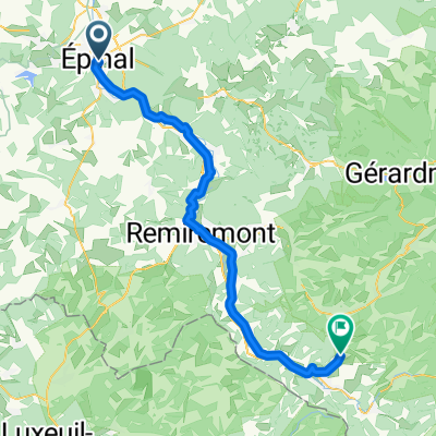
2009 Euro Tour -- Ride Day 30 — 29 July 2009 — 88000 Epinal to 88400 Xonrupt-Longemer
Un itinéraire vélo au départ de Épinal, Grand Est, France.
Vue d'ensemble
À propos du circuit
Belle route, mais terrible pour les vélos car le trafic était relativement lourd et il n'y avait pas d'accotements. La seule exception était la D417 à Gérardmer et Xonrupt-Longemer où il y avait une bonne piste cyclable pour gérer tout ce trafic. La plupart de cette courte promenade en zigzag était une montée facile d'environ 300 ou 400 mètres jusqu'à environ 700 mètres à notre hôtel. Nous avions remarqué que cette section du nord-est semble relativement plus prospère que la plupart des autres parties de la France que nous avons traversées durant ce voyage. Surtout hier, nous avons vu beaucoup de constructions neuves et quelques piscines enterrées. Aujourd'hui, en parcourant la D417, il y avait de nombreuses entreprises de construction de maisons qui avaient mis en place des maisons modèles pour que les gens puissent acheter pour leurs propres terrains. Ce trajet se faisait entièrement dans le département des Vosges en région Lorraine. Contexte : Ma femme et moi faisons des tours auto-soutenues en Europe de l'Ouest (la majorité en France) depuis 1993. Cette série de trajets couvre notre itinéraire de 4,5 mois en 2009 à travers des parties de France, d'Allemagne, d'Autriche, de Suisse, puis de retour en France. Notre point de départ et d'arrivée se trouve près de Chadurie (au sud d'Angoulême) où nos amis ont une ferme avec des Gîtes et Chambres d'Hôtes. Nous avons parcouru nos vélos de tourisme Dawes achetés en 1993, fortement chargés avec des pneus 700Cx32. Tous nos trajets se sont faits sur des routes pavées, principalement avec très peu de trafic. À peu près les seules sections non pavées étaient quelques chemins de vélo en Allemagne et en Autriche. Malheureusement, ce n'était pas si génial car Helen est tombée plusieurs fois sur les chemins non pavés. Heureusement, pas de blessures graves. Pour toute question, n'hésitez pas à m'écrire à jeffkadet@netdiving.com. Jeff
- -:--
- Durée
- 48,8 km
- Distance
- 519 m
- Montée
- 169 m
- Descente
- ---
- Vit. moyenne
- ---
- Altitude max.

Qualité de l’itinéraire
Types de voies et surfaces le long de l’itinéraire
Types de routes
Route tranquille
4,4 km
(9 %)
Route
1,5 km
(3 %)
surfaces
Pavé
34,7 km
(71 %)
Asphalte
34,7 km
(71 %)
Indéfini
14,2 km
(29 %)
Continuer avec Bikemap
Utilise, modifie ou télécharge cet itinéraire vélo
Tu veux parcourir 2009 Euro Tour -- Ride Day 30 — 29 July 2009 — 88000 Epinal to 88400 Xonrupt-Longemer ou l’adapter à ton propre voyage ? Voici ce que tu peux faire avec cet itinéraire Bikemap :
Fonctionnalités gratuites
- Enregistre cet itinéraire comme favori ou dans une collection
- Copie et planifie ta propre version de cet itinéraire
- Synchronise ton itinéraire avec Garmin ou Wahoo
Fonctionnalités Premium
Essai gratuit de 3 jours, ou paiement unique. En savoir plus sur Bikemap Premium.
- Navigue sur cet itinéraire sur iOS et Android
- Exporter un fichier GPX / KML de cet itinéraire
- Crée ton impression personnalisée (essaie-la gratuitement)
- Télécharge cet itinéraire pour la navigation hors ligne
Découvre plus de fonctionnalités Premium.
Obtiens Bikemap PremiumDe notre communauté
Épinal : Autres itinéraires populaires qui commencent ici
 De Épinal à Velle-sur-Moselle
- Distance
- 49,3 km
- Montée
- 76 m
- Descente
- 167 m
- Emplacement
- Épinal, Grand Est, France
 Boucle Raon- Mailleronfaing-Lamenil
- Distance
- 70,1 km
- Montée
- 513 m
- Descente
- 509 m
- Emplacement
- Épinal, Grand Est, France
 CommercyTour2022_E3-3
- Distance
- 126,4 km
- Montée
- 1 301 m
- Descente
- 1 370 m
- Emplacement
- Épinal, Grand Est, France
 2009 Euro Tour -- Ride Day 30 — 29 July 2009 — 88000 Epinal to 88400 Xonrupt-Longemer
- Distance
- 48,8 km
- Montée
- 519 m
- Descente
- 169 m
- Emplacement
- Épinal, Grand Est, France
 Tag 2 Von Epinal bis Nancy
- Distance
- 76 km
- Montée
- 174 m
- Descente
- 303 m
- Emplacement
- Épinal, Grand Est, France
 Dag 13 Haugen
- Distance
- 80,9 km
- Montée
- 546 m
- Descente
- 633 m
- Emplacement
- Épinal, Grand Est, France
 2009 Euro Tour -- Ride Day 29 — 28 July 2009 — 88000 Epinal — Circle
- Distance
- 80,5 km
- Montée
- 476 m
- Descente
- 476 m
- Emplacement
- Épinal, Grand Est, France
 epinal - le menil bei le thillot
- Distance
- 54,9 km
- Montée
- 510 m
- Descente
- 314 m
- Emplacement
- Épinal, Grand Est, France
Ouvre-la dans l’app