

Shining Sea Bike Path, Falmouth MA CLONED FROM ROUTE 725885
Un itinéraire vélo au départ de North Falmouth, Massachusetts, United States of America.
Vue d'ensemble
À propos du circuit
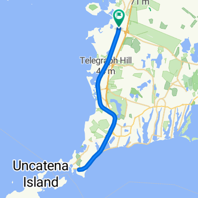
One end of the bike path is in North Falmouth and the other is in Woods Hole. The path follows the old railroad grade so is fairly flat with gradual rises. It is for bicycles, running, roller blades, and walking.
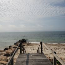
It passes by salt marshes and beaches while traveling through some woods. The views along the path are to the west so the sunset over the salt marshes can be amazing.
There are a number of ice cream shops along the way as well as a few restaurants. Parking lots are at both ends and a few along the way. On weekends during the summer thousands of people use the path during the day, but in early evening the numbers have thinned out. Fall is a great time to see the foliage and relatively few people on the path.
- -:--
- Durée
- 17,1 km
- Distance
- 98 m
- Montée
- 114 m
- Descente
- ---
- Vit. moyenne
- ---
- Altitude max.
Continuer avec Bikemap
Utilise, modifie ou télécharge cet itinéraire vélo
Tu veux parcourir Shining Sea Bike Path, Falmouth MA CLONED FROM ROUTE 725885 ou l’adapter à ton propre voyage ? Voici ce que tu peux faire avec cet itinéraire Bikemap :
Fonctionnalités gratuites
- Enregistre cet itinéraire comme favori ou dans une collection
- Copie et planifie ta propre version de cet itinéraire
- Synchronise ton itinéraire avec Garmin ou Wahoo
Fonctionnalités Premium
Essai gratuit de 3 jours, ou paiement unique. En savoir plus sur Bikemap Premium.
- Navigue sur cet itinéraire sur iOS et Android
- Exporter un fichier GPX / KML de cet itinéraire
- Crée ton impression personnalisée (essaie-la gratuitement)
- Télécharge cet itinéraire pour la navigation hors ligne
Découvre plus de fonctionnalités Premium.
Obtiens Bikemap PremiumDe notre communauté
North Falmouth : Autres itinéraires populaires qui commencent ici
 Recovered Route
- Distance
- 12,1 km
- Montée
- 35 m
- Descente
- 39 m
- Emplacement
- North Falmouth, Massachusetts, United States of America
 edward gorey loop_11/8
- Distance
- 107,3 km
- Montée
- 117 m
- Descente
- 135 m
- Emplacement
- North Falmouth, Massachusetts, United States of America
 Depot Rd, North Falmouth to 35 County Rd, North Falmouth
- Distance
- 34,8 km
- Montée
- 132 m
- Descente
- 132 m
- Emplacement
- North Falmouth, Massachusetts, United States of America
 Goeletta Drive 150, Falmouth to Goeletta Drive 154, Falmouth
- Distance
- 41,3 km
- Montée
- 99 m
- Descente
- 105 m
- Emplacement
- North Falmouth, Massachusetts, United States of America
 Edward Gorey
- Distance
- 88,2 km
- Montée
- 180 m
- Descente
- 174 m
- Emplacement
- North Falmouth, Massachusetts, United States of America
 Steady ride in North Falmouth
- Distance
- 33,5 km
- Montée
- 6 m
- Descente
- 23 m
- Emplacement
- North Falmouth, Massachusetts, United States of America
 cape cod canal et bord de mer
- Distance
- 86,3 km
- Montée
- 177 m
- Descente
- 178 m
- Emplacement
- North Falmouth, Massachusetts, United States of America
 35 County Rd, North Falmouth to 35 County Rd, North Falmouth
- Distance
- 34,7 km
- Montée
- 119 m
- Descente
- 120 m
- Emplacement
- North Falmouth, Massachusetts, United States of America
Ouvre-la dans l’app