
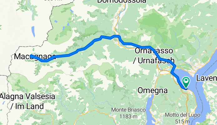
Stresa - Macugnaga
Un itinéraire vélo au départ de Stresa, Piémont, Italie.
Vue d'ensemble
À propos du circuit
The finish of Stage 19 of the 2011 Giro ‘Italia the journey to Macugnaga is a truly spectacular ride up the Anzasca Valley.
On top of the mountain valley, whose name comes from the river Anza which runs there, is the second highest mountain in the Alps and in western Europe: the imposing Mount Rosa, 4,638m high.
Mount Rosa overlooks the untouched village of Macugnaga that was colonized in the 13th century by the Walser people..
- 6 h 54 min
- Durée
- 121 km
- Distance
- 1 353 m
- Montée
- 1 346 m
- Descente
- 17,5 km/h
- Vit. moyenne
- 1 404 m
- Altitude max.
Photos de l’itinéraire


Qualité de l’itinéraire
Types de voies et surfaces le long de l’itinéraire
Types de routes
Route fréquentée
108,5 km
(90 %)
Route tranquille
7,9 km
(7 %)
surfaces
Pavé
111,4 km
(92 %)
Non pavé
1,1 km
(<1 %)
Asphalte
110,7 km
(91 %)
Non pavé (non défini)
0,7 km
(<1 %)
Continuer avec Bikemap
Utilise, modifie ou télécharge cet itinéraire vélo
Tu veux parcourir Stresa - Macugnaga ou l’adapter à ton propre voyage ? Voici ce que tu peux faire avec cet itinéraire Bikemap :
Fonctionnalités gratuites
- Enregistre cet itinéraire comme favori ou dans une collection
- Copie et planifie ta propre version de cet itinéraire
- Divise-le en étapes pour créer un tour sur plusieurs jours
- Synchronise ton itinéraire avec Garmin ou Wahoo
Fonctionnalités Premium
Essai gratuit de 3 jours, ou paiement unique. En savoir plus sur Bikemap Premium.
- Navigue sur cet itinéraire sur iOS et Android
- Exporter un fichier GPX / KML de cet itinéraire
- Crée ton impression personnalisée (essaie-la gratuitement)
- Télécharge cet itinéraire pour la navigation hors ligne
Découvre plus de fonctionnalités Premium.
Obtiens Bikemap PremiumDe notre communauté
Stresa : Autres itinéraires populaires qui commencent ici
 Giro del Lago d'Orta - Giro del Lago d'Orta
- Distance
- 71,5 km
- Montée
- 617 m
- Descente
- 617 m
- Emplacement
- Stresa, Piémont, Italie
 stresa-orta san giuglio
- Distance
- 58,8 km
- Montée
- 1 646 m
- Descente
- 1 649 m
- Emplacement
- Stresa, Piémont, Italie
 2018-09-19
- Distance
- 71 km
- Montée
- 379 m
- Descente
- 366 m
- Emplacement
- Stresa, Piémont, Italie
 STRESA-MOTTARONE-MIASINO-MILANO
- Distance
- 131,5 km
- Montée
- 1 260 m
- Descente
- 1 334 m
- Emplacement
- Stresa, Piémont, Italie
 Orta Lago al lago maggiore...a Via Sempione Nord 24, Stresa a Via Sempione Nord 28, Stresa
- Distance
- 67,8 km
- Montée
- 1 599 m
- Descente
- 1 604 m
- Emplacement
- Stresa, Piémont, Italie
 Corso Umberto Prima 33, Stresa nach Corso Umberto I 33, Stresa
- Distance
- 40,7 km
- Montée
- 2 651 m
- Descente
- 2 655 m
- Emplacement
- Stresa, Piémont, Italie
 giro 1
- Distance
- 23,4 km
- Montée
- 2 009 m
- Descente
- 2 003 m
- Emplacement
- Stresa, Piémont, Italie
 anello mottarone da stresa
- Distance
- 54 km
- Montée
- 1 263 m
- Descente
- 1 278 m
- Emplacement
- Stresa, Piémont, Italie
Ouvre-la dans l’app