

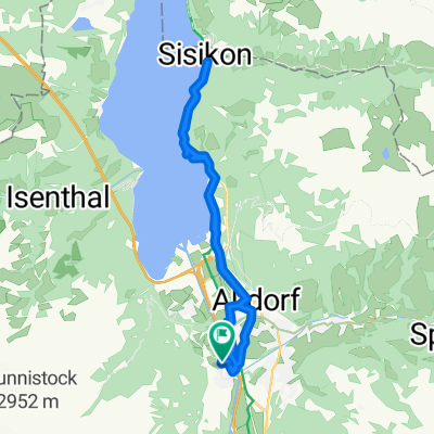
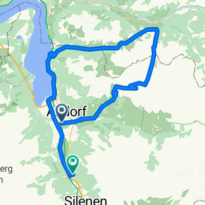
Attinghausen - Erstfeld- Attingh.
Un itinéraire vélo au départ de Attinghausen, Canton d’Uri, Suisse.
Vue d'ensemble
À propos du circuit
Mon itinéraire habituel de jogging passe par Hochweg jusqu'au pont Reuss à Erstfeld et revient par Reussdamm jusqu'à Attinghausen. (Les données d'altitude ne sont pas correctes car un tunnel traverse le rocher)
- -:--
- Durée
- 10,8 km
- Distance
- 284 m
- Montée
- 279 m
- Descente
- ---
- Vit. moyenne
- 553 m
- Altitude max.

Qualité de l’itinéraire
Types de voies et surfaces le long de l’itinéraire
Types de routes
Route forestière
6,2 km
(57 %)
Sentier
1,4 km
(13 %)
surfaces
Pavé
3,1 km
(29 %)
Non pavé
6,6 km
(61 %)
Gravier
2,8 km
(26 %)
Gravier meuble
2,7 km
(25 %)
Continuer avec Bikemap
Utilise, modifie ou télécharge cet itinéraire vélo
Tu veux parcourir Attinghausen - Erstfeld- Attingh. ou l’adapter à ton propre voyage ? Voici ce que tu peux faire avec cet itinéraire Bikemap :
Fonctionnalités gratuites
- Enregistre cet itinéraire comme favori ou dans une collection
- Copie et planifie ta propre version de cet itinéraire
- Synchronise ton itinéraire avec Garmin ou Wahoo
Fonctionnalités Premium
Essai gratuit de 3 jours, ou paiement unique. En savoir plus sur Bikemap Premium.
- Navigue sur cet itinéraire sur iOS et Android
- Exporter un fichier GPX / KML de cet itinéraire
- Crée ton impression personnalisée (essaie-la gratuitement)
- Télécharge cet itinéraire pour la navigation hors ligne
Découvre plus de fonctionnalités Premium.
Obtiens Bikemap PremiumDe notre communauté
Attinghausen : Autres itinéraires populaires qui commencent ici
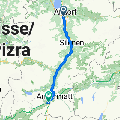
 Schattdorf-Andermatt
- Distance
- 35,5 km
- Montée
- 1 043 m
- Descente
- 84 m
- Emplacement
- Attinghausen, Canton d’Uri, Suisse
 Attinghausen-Klauenpass-Eggberge-Attinghausen
- Distance
- 58,9 km
- Montée
- 2 242 m
- Descente
- 2 240 m
- Emplacement
- Attinghausen, Canton d’Uri, Suisse
 Attinghausen - Andermatt
- Distance
- 36,9 km
- Montée
- 1 813 m
- Descente
- 745 m
- Emplacement
- Attinghausen, Canton d’Uri, Suisse
 Attinghausen-Brüsti-Attinghausen
- Distance
- 18,2 km
- Montée
- 1 319 m
- Descente
- 1 320 m
- Emplacement
- Attinghausen, Canton d’Uri, Suisse
 Obere Postmatte 1, Attinghausen to Obere Postmatte 1, Attinghausen
- Distance
- 26,1 km
- Montée
- 397 m
- Descente
- 385 m
- Emplacement
- Attinghausen, Canton d’Uri, Suisse
 Surenenpass-Erstfeld
- Distance
- 11,6 km
- Montée
- 77 m
- Descente
- 1 881 m
- Emplacement
- Attinghausen, Canton d’Uri, Suisse
 Altdorf- Kinzig-Muothatal-Erstfeld
- Distance
- 50,3 km
- Montée
- 2 420 m
- Descente
- 2 399 m
- Emplacement
- Attinghausen, Canton d’Uri, Suisse
 A2, Schattdorf nach A2, Schattdorf
- Distance
- 0,1 km
- Montée
- 0 m
- Descente
- 0 m
- Emplacement
- Attinghausen, Canton d’Uri, Suisse
Ouvre-la dans l’app