
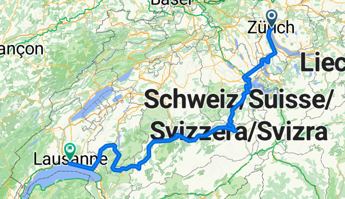
Lakes Route - Zurich to Lausanne
Un itinéraire vélo au départ de Zürich (Kreis 6) / Oberstrass, Canton of Zurich, Switzerland.
Vue d'ensemble
À propos du circuit
More about the Lakes Route:
https://www.cyclingthread.com/exploring-swiss-alps-cycling-lakes-route-in-switzerland
The Lakes Route is a 500-kilometer cycling route across postcard-like Switzerland, linking ten scenic lakes and regions such as Werdenberg, Lucerne at the foot of Mount Pilatus, Iseltwald on Lake Brienz, Gruyères, and the Lavaux vineyards above Lake Geneva. The version described starts in Zurich and finishes in Lausanne, passing through Zug, Lucerne, Meiringen, Interlaken, Spiez, and Gstaad. According to Switzerland Mobility, the route is about 510 km long with a total elevation gain of roughly 5900 m. It offers outstanding views of Alpine lakes, charming towns, and valleys, making it perfect for a multi-day journey. Many riders plan 6 to 8 days to complete the route, depending on pace and stops. Its demanding profile with climbs and descents makes it both challenging and rewarding. In the end, the Lakes Route is a well-organized and scenic cycling adventure that captures the variety of Swiss landscapes.
- 23 h 31 min
- Durée
- 341,3 km
- Distance
- 5 957 m
- Montée
- 5 992 m
- Descente
- 14,5 km/h
- Vit. moyenne
- 1 285 m
- Altitude max.

Photos de l’itinéraire


Continuer avec Bikemap
Utilise, modifie ou télécharge cet itinéraire vélo
Tu veux parcourir Lakes Route - Zurich to Lausanne ou l’adapter à ton propre voyage ? Voici ce que tu peux faire avec cet itinéraire Bikemap :
Fonctionnalités gratuites
- Enregistre cet itinéraire comme favori ou dans une collection
- Copie et planifie ta propre version de cet itinéraire
- Divise-le en étapes pour créer un tour sur plusieurs jours
- Synchronise ton itinéraire avec Garmin ou Wahoo
Fonctionnalités Premium
Essai gratuit de 3 jours, ou paiement unique. En savoir plus sur Bikemap Premium.
- Navigue sur cet itinéraire sur iOS et Android
- Exporter un fichier GPX / KML de cet itinéraire
- Crée ton impression personnalisée (essaie-la gratuitement)
- Télécharge cet itinéraire pour la navigation hors ligne
Découvre plus de fonctionnalités Premium.
Obtiens Bikemap PremiumDe notre communauté
Zürich (Kreis 6) / Oberstrass : Autres itinéraires populaires qui commencent ici
 Rennvelotour - Zürich, Greifensee und Umland
- Distance
- 83,3 km
- Montée
- 816 m
- Descente
- 818 m
- Emplacement
- Zürich (Kreis 6) / Oberstrass, Canton of Zurich, Switzerland
 Day 1 - Zurich to Walenstadt
- Distance
- 85,9 km
- Montée
- 194 m
- Descente
- 226 m
- Emplacement
- Zürich (Kreis 6) / Oberstrass, Canton of Zurich, Switzerland
 ASVZ Donnerstags Sommerrunde Züri Oberland
- Distance
- 58,6 km
- Montée
- 837 m
- Descente
- 900 m
- Emplacement
- Zürich (Kreis 6) / Oberstrass, Canton of Zurich, Switzerland
 ASVZ-Runde Mont Sonnenbüel
- Distance
- 63,6 km
- Montée
- 696 m
- Descente
- 753 m
- Emplacement
- Zürich (Kreis 6) / Oberstrass, Canton of Zurich, Switzerland
 Ausfahrt durch Zürich
- Distance
- 15,6 km
- Montée
- 283 m
- Descente
- 311 m
- Emplacement
- Zürich (Kreis 6) / Oberstrass, Canton of Zurich, Switzerland
 Giro ASVZ
- Distance
- 88,8 km
- Montée
- 1 263 m
- Descente
- 1 331 m
- Emplacement
- Zürich (Kreis 6) / Oberstrass, Canton of Zurich, Switzerland
 Giro ASVZ
- Distance
- 88,9 km
- Montée
- 898 m
- Descente
- 898 m
- Emplacement
- Zürich (Kreis 6) / Oberstrass, Canton of Zurich, Switzerland
 ASVZ Donnerstagsrunde
- Distance
- 45,9 km
- Montée
- 455 m
- Descente
- 526 m
- Emplacement
- Zürich (Kreis 6) / Oberstrass, Canton of Zurich, Switzerland
Ouvre-la dans l’app