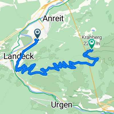
Landeck-Torbole

Un itinéraire vélo au départ de Zams, Tyrol, Autriche.
Vue d'ensembleÀ propos du circuit
-:--
Durée
5,3 km
Distance
270 m
Montée
270 m
Descente
---
Vit. moyenne
---
Altitude max.
surfguzzycréé il y a 13 ans
Points forts de l’itinĂ©rairePoints d’intĂ©rĂȘt le long de l’itinĂ©raire
  1. Point d'intĂ©rĂȘt aprĂšs 0 km

  2. Point d'intĂ©rĂȘt aprĂšs 0 km

  3. Point d'intĂ©rĂȘt aprĂšs 0 km

  4. Point d'intĂ©rĂȘt aprĂšs 0 km

  5. Point d'intĂ©rĂȘt aprĂšs 0 km

  6. Point d'intĂ©rĂȘt aprĂšs 0 km

  7. Point d'intĂ©rĂȘt aprĂšs 0 km

  8. Point d'intĂ©rĂȘt aprĂšs 0 km

  9. Point d'intĂ©rĂȘt aprĂšs 0 km

  10. Point d'intĂ©rĂȘt aprĂšs 0 km

  11. Point d'intĂ©rĂȘt aprĂšs 0 km

  12. Point d'intĂ©rĂȘt aprĂšs 0 km

  13. Point d'intĂ©rĂȘt aprĂšs 0 km

  14. Point d'intĂ©rĂȘt aprĂšs 0 km

  15. Point d'intĂ©rĂȘt aprĂšs 0 km

  16. Point d'intĂ©rĂȘt aprĂšs 2,8 km

  17. Point d'intĂ©rĂȘt aprĂšs 2,8 km

  18. Point d'intĂ©rĂȘt aprĂšs 2,8 km

  19. Point d'intĂ©rĂȘt aprĂšs 2,8 km

  20. Point d'intĂ©rĂȘt aprĂšs 2,8 km

  21. Point d'intĂ©rĂȘt aprĂšs 2,8 km

  22. Point d'intĂ©rĂȘt aprĂšs 2,8 km

  23. Point d'intĂ©rĂȘt aprĂšs 2,8 km

  24. Point d'intĂ©rĂȘt aprĂšs 2,8 km

  25. Point d'intĂ©rĂȘt aprĂšs 2,8 km

  26. Point d'intĂ©rĂȘt aprĂšs 2,8 km

  27. Point d'intĂ©rĂȘt aprĂšs 2,8 km

  28. Point d'intĂ©rĂȘt aprĂšs 2,8 km

  29. Point d'intĂ©rĂȘt aprĂšs 2,8 km

  30. Point d'intĂ©rĂȘt aprĂšs 2,8 km

  31. Point d'intĂ©rĂȘt aprĂšs 2,8 km

  32. Point d'intĂ©rĂȘt aprĂšs 2,8 km

  33. Point d'intĂ©rĂȘt aprĂšs 2,8 km

  34. Point d'intĂ©rĂȘt aprĂšs 2,8 km

  35. Point d'intĂ©rĂȘt aprĂšs 2,8 km

  36. Point d'intĂ©rĂȘt aprĂšs 2,8 km

  37. Point d'intĂ©rĂȘt aprĂšs 2,8 km

  38. Point d'intĂ©rĂȘt aprĂšs 2,8 km

  39. Point d'intĂ©rĂȘt aprĂšs 2,8 km

  40. Point d'intĂ©rĂȘt aprĂšs 2,8 km

  41. Point d'intĂ©rĂȘt aprĂšs 2,8 km

  42. Point d'intĂ©rĂȘt aprĂšs 2,8 km

  43. Point d'intĂ©rĂȘt aprĂšs 2,8 km

  44. Point d'intĂ©rĂȘt aprĂšs 2,8 km

  45. Point d'intĂ©rĂȘt aprĂšs 2,8 km

  46. Point d'intĂ©rĂȘt aprĂšs 2,8 km

  47. Point d'intĂ©rĂȘt aprĂšs 2,8 km

  48. Point d'intĂ©rĂȘt aprĂšs 2,8 km

  49. Point d'intĂ©rĂȘt aprĂšs 2,8 km

  50. Point d'intĂ©rĂȘt aprĂšs 2,8 km

  51. Point d'intĂ©rĂȘt aprĂšs 2,8 km

  52. Point d'intĂ©rĂȘt aprĂšs 2,8 km

  53. Point d'intĂ©rĂȘt aprĂšs 2,8 km

  54. Point d'intĂ©rĂȘt aprĂšs 2,8 km

  55. Point d'intĂ©rĂȘt aprĂšs 2,8 km

  56. Point d'intĂ©rĂȘt aprĂšs 2,8 km

  57. Point d'intĂ©rĂȘt aprĂšs 2,8 km

  58. Point d'intĂ©rĂȘt aprĂšs 2,8 km

  59. Point d'intĂ©rĂȘt aprĂšs 2,8 km

  60. Point d'intĂ©rĂȘt aprĂšs 2,8 km

  61. Point d'intĂ©rĂȘt aprĂšs 2,8 km

  62. Point d'intĂ©rĂȘt aprĂšs 3,6 km

  63. Point d'intĂ©rĂȘt aprĂšs 4,7 km

Continuer avec BikemapUtilise, modifie ou télécharge cet itinéraire vélo
Tu veux parcourir Landeck-Torbole ou l’adapter Ă  ton propre voyage ? Voici ce que tu peux faire avec cet itinĂ©raire Bikemap :
Fonctionnalités gratuites
Fonctionnalités Premium

Essai gratuit de 3 jours, ou paiement unique. En savoir plus sur Bikemap Premium.

  • Navigue sur cet itinĂ©raire sur iOS et Android
  • Exporter un fichier GPX / KML de cet itinĂ©raire
  • CrĂ©e ton impression personnalisĂ©e (essaie-la gratuitement)
  • TĂ©lĂ©charge cet itinĂ©raire pour la navigation hors ligne

Découvre plus de fonctionnalités Premium.

Obtiens Bikemap Premium
De notre communautéZams : Autres itinéraires populaires qui commencent ici

Ouvre-la dans l’app