

St Andrews Pilgrimage, from southern upland way to edinburgh
Un itinéraire vélo au départ de Innerleithen, Ecosse, Royaume-Uni.
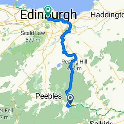
Vue d'ensemble
À propos du circuit
- -:--
- Durée
- 65,3 km
- Distance
- 677 m
- Montée
- 765 m
- Descente
- ---
- Vit. moyenne
- ---
- Altitude max.
Points forts de l’itinéraire
Points d’intérêt le long de l’itinéraire

Photo après 0 km
Hébergement après 13,7 km
Campsite
Hébergement après 17,7 km
Hotel
Point d'intérêt après 20,7 km
Tearoom with restaurant
Hébergement après 20,7 km
Inn with rooms
Hébergement après 30,2 km
Pub
Hébergement après 32,3 km
bistro/restaurant
Hébergement après 42,5 km
Inn
Hébergement après 65,3 km
Hostel
Continuer avec Bikemap
Utilise, modifie ou télécharge cet itinéraire vélo
Tu veux parcourir St Andrews Pilgrimage, from southern upland way to edinburgh ou l’adapter à ton propre voyage ? Voici ce que tu peux faire avec cet itinéraire Bikemap :
Fonctionnalités gratuites
- Enregistre cet itinéraire comme favori ou dans une collection
- Copie et planifie ta propre version de cet itinéraire
- Synchronise ton itinéraire avec Garmin ou Wahoo
Fonctionnalités Premium
Essai gratuit de 3 jours, ou paiement unique. En savoir plus sur Bikemap Premium.
- Navigue sur cet itinéraire sur iOS et Android
- Exporter un fichier GPX / KML de cet itinéraire
- Crée ton impression personnalisée (essaie-la gratuitement)
- Télécharge cet itinéraire pour la navigation hors ligne
Découvre plus de fonctionnalités Premium.
Obtiens Bikemap PremiumDe notre communauté
Innerleithen : Autres itinéraires populaires qui commencent ici
 St Andrews Pilgrimage, from southern upland way to edinburgh
- Distance
- 65,3 km
- Montée
- 677 m
- Descente
- 765 m
- Emplacement
- Innerleithen, Ecosse, Royaume-Uni
 Pre-afternoon tea cycle
- Distance
- 63,1 km
- Montée
- 512 m
- Descente
- 507 m
- Emplacement
- Innerleithen, Ecosse, Royaume-Uni
 2.3 Southern Upland Way
- Distance
- 11,8 km
- Montée
- 341 m
- Descente
- 401 m
- Emplacement
- Innerleithen, Ecosse, Royaume-Uni
 St Wilfrid's Way-Innerleithen via Cardrona to Peebles
- Distance
- 12 km
- Montée
- 141 m
- Descente
- 139 m
- Emplacement
- Innerleithen, Ecosse, Royaume-Uni
 Coasts & Castles Day 3: Innerleithen - Edinburgh
- Distance
- 61,1 km
- Montée
- 428 m
- Descente
- 487 m
- Emplacement
- Innerleithen, Ecosse, Royaume-Uni
 2.2 Southern Upland Way
- Distance
- 5,5 km
- Montée
- 32 m
- Descente
- 31 m
- Emplacement
- Innerleithen, Ecosse, Royaume-Uni
 JOGLE Day 9
- Distance
- 96 km
- Montée
- 633 m
- Descente
- 751 m
- Emplacement
- Innerleithen, Ecosse, Royaume-Uni
 Innerleithan
- Distance
- 59,9 km
- Montée
- 1 421 m
- Descente
- 1 423 m
- Emplacement
- Innerleithen, Ecosse, Royaume-Uni
Ouvre-la dans l’app