
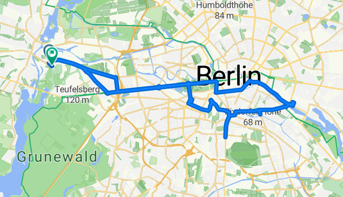
Ruhleben bis Ostbahnhof-Tempelhofer Flughafen-Ruhleben
Un itinéraire vélo au départ de Berlin-Haselhorst, Ville-État de Berlin, Allemagne.
Vue d'ensemble
À propos du circuit
De Ruhleben à la gare Ostbahnhof et retour à l'aéroport de Tempelhof avec une visite et le Zoo avec un arrêt au Cafe am neuen See.
- -:--
- Durée
- 45,7 km
- Distance
- 109 m
- Montée
- 105 m
- Descente
- ---
- Vit. moyenne
- ---
- Altitude max.
Qualité de l’itinéraire
Types de voies et surfaces le long de l’itinéraire
Types de routes
Piste cyclable
10,5 km
(23 %)
Route tranquille
9,1 km
(20 %)
surfaces
Pavé
36,6 km
(80 %)
Asphalte
36,1 km
(79 %)
Béton
0,5 km
(1 %)
Indéfini
9,1 km
(20 %)
Continuer avec Bikemap
Utilise, modifie ou télécharge cet itinéraire vélo
Tu veux parcourir Ruhleben bis Ostbahnhof-Tempelhofer Flughafen-Ruhleben ou l’adapter à ton propre voyage ? Voici ce que tu peux faire avec cet itinéraire Bikemap :
Fonctionnalités gratuites
- Enregistre cet itinéraire comme favori ou dans une collection
- Copie et planifie ta propre version de cet itinéraire
- Synchronise ton itinéraire avec Garmin ou Wahoo
Fonctionnalités Premium
Essai gratuit de 3 jours, ou paiement unique. En savoir plus sur Bikemap Premium.
- Navigue sur cet itinéraire sur iOS et Android
- Exporter un fichier GPX / KML de cet itinéraire
- Crée ton impression personnalisée (essaie-la gratuitement)
- Télécharge cet itinéraire pour la navigation hors ligne
Découvre plus de fonctionnalités Premium.
Obtiens Bikemap PremiumDe notre communauté
Berlin-Haselhorst : Autres itinéraires populaires qui commencent ici
 Kol.Am Rohrdamm 70, Berlin nach Kol. Olympia 35, Berlin
- Distance
- 6,2 km
- Montée
- 54 m
- Descente
- 62 m
- Emplacement
- Berlin-Haselhorst, Ville-État de Berlin, Allemagne
 Ruhleben bis Ostbahnhof-Tempelhofer Flughafen-Ruhleben
- Distance
- 45,7 km
- Montée
- 109 m
- Descente
- 105 m
- Emplacement
- Berlin-Haselhorst, Ville-État de Berlin, Allemagne
 Oberkrämerrunde
- Distance
- 96,2 km
- Montée
- 152 m
- Descente
- 142 m
- Emplacement
- Berlin-Haselhorst, Ville-État de Berlin, Allemagne
 Trainingsrunde Grunewald 70
- Distance
- 67,2 km
- Montée
- 275 m
- Descente
- 276 m
- Emplacement
- Berlin-Haselhorst, Ville-État de Berlin, Allemagne
 Schloßpark und Regierungsviertel Spreeweg
- Distance
- 27 km
- Montée
- 75 m
- Descente
- 75 m
- Emplacement
- Berlin-Haselhorst, Ville-État de Berlin, Allemagne
 Berlin Kuntzke 08
- Distance
- 39,8 km
- Montée
- 56 m
- Descente
- 56 m
- Emplacement
- Berlin-Haselhorst, Ville-État de Berlin, Allemagne
 Berlin nach Brieselang_2
- Distance
- 22 km
- Montée
- 29 m
- Descente
- 32 m
- Emplacement
- Berlin-Haselhorst, Ville-État de Berlin, Allemagne
 eine morgen Runde
- Distance
- 25,7 km
- Montée
- 50 m
- Descente
- 51 m
- Emplacement
- Berlin-Haselhorst, Ville-État de Berlin, Allemagne
Ouvre-la dans l’app