

Armidale to Kootingal railway station
Un itinéraire vélo au départ de Armidale, Nouvelle-Galles du Sud, Australie.
Vue d'ensemble
À propos du circuit
This was a really fun ride, done on a day when I just needed to escape from life! I had ogled the road that follows the railway line on a train trip shortly beforehand and decided that I needed to ride that road. From Armidale I took one of the standard cycling routes to Uralla following Bundarra road and Hawthorne drive. Instead of going across to Thunderbolts way for the ride into Uralla, I took Barleyfields Rd, as this was a "railway line ride".
After a quick coffee and cake in Uralla (I needed plenty of fuel to make it all the way to Kootingal), I headed up the NE highway. This has a decent shoulder but the traffic is fast and I don't like riding this road. However, the 12 k to the Kentucky turnoff was soon knocked off and I had quiet roads for the rest of the day. Noalimba and Wollun Rds are a lovely ride; paved and scenic although the route is increasingly undulating towards Woolbrook. The short section of the Oxley highway has a bit more traffic but does have a narrow shoulder and visibility is mostly good. I stopped to have lunch at the picnic area at Woolbrook, expecting to also be able to top up on water. ALthough it was a lovely place to stop, the loo is a long drop, no tap, what a pity there isn't a rainwater tank. I was a little concerned about water as I had already drunk most of my water on a warm day. These days I always carry more water. Neverthless, the next section was downhill. From Woolbrook the seal runs out and there are 30 km of dirt to Limbri. At first this was badly corrugated; by the time I got to the end I was minus my back light and I assume it rattled off on this section. However, after a short distance the road use must drop dramatically because the surface was much better. Apart from some corners with corrugations and loose gravel it was fine to ride on 35 mm tyres. I saw about 2 cars the whole way down and had a really fun descent. I was pleased to see the seal again at Limbri, where I was also able to get some more water from a local. From Limbri the road follows the Cockburn river, which at that time was flowing clear and strong. I stopped for a snack at the Cockburn river camping/picnic area, a bit run down but by a lovely swimming hole - wished I had packed my swimmers. Almost too soon I was out of the narrow valley and approaching Kootingal. I had prebooked a train seat and bike box by phone so then had to proceed to partially dismantle my bike. This was a fiasco because my old dumbell aluminium spanner broke and the train came with the bike only partly dismantled. Fortunately the guard didn't mind, nor did they care whether the bike actually went in the box as the luggage section of the train was almost completely empty. Although I was able to get a train ride back home quite easily on this occasion, I was not able to repeat this more recently. NSW rail refused to send a box on the train, requiring the bike to be boxed before the train arrived - impossible at an unmanned station. It's a great pity NSW trainlink is not more bike friendly.
- -:--
- Durée
- 122,6 km
- Distance
- 406 m
- Montée
- 953 m
- Descente
- ---
- Vit. moyenne
- ---
- Altitude max.

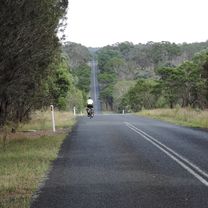
Photos de l’itinéraire


Qualité de l’itinéraire
Types de voies et surfaces le long de l’itinéraire
Types de routes
Route tranquille
50,5 km
(41 %)
Route
45,7 km
(37 %)
surfaces
Pavé
95,7 km
(78 %)
Non pavé
26,9 km
(22 %)
Asphalte
85,2 km
(69 %)
Non pavé (non défini)
26,9 km
(22 %)
Continuer avec Bikemap
Utilise, modifie ou télécharge cet itinéraire vélo
Tu veux parcourir Armidale to Kootingal railway station ou l’adapter à ton propre voyage ? Voici ce que tu peux faire avec cet itinéraire Bikemap :
Fonctionnalités gratuites
- Enregistre cet itinéraire comme favori ou dans une collection
- Copie et planifie ta propre version de cet itinéraire
- Divise-le en étapes pour créer un tour sur plusieurs jours
- Synchronise ton itinéraire avec Garmin ou Wahoo
Fonctionnalités Premium
Essai gratuit de 3 jours, ou paiement unique. En savoir plus sur Bikemap Premium.
- Navigue sur cet itinéraire sur iOS et Android
- Exporter un fichier GPX / KML de cet itinéraire
- Crée ton impression personnalisée (essaie-la gratuitement)
- Télécharge cet itinéraire pour la navigation hors ligne
Découvre plus de fonctionnalités Premium.
Obtiens Bikemap PremiumDe notre communauté
Armidale : Autres itinéraires populaires qui commencent ici
 Armidale to Point Lookout loop
- Distance
- 226,3 km
- Montée
- 4 225 m
- Descente
- 4 225 m
- Emplacement
- Armidale, Nouvelle-Galles du Sud, Australie
 Avoiding the Waterfall Way from Armidale
- Distance
- 92,5 km
- Montée
- 708 m
- Descente
- 708 m
- Emplacement
- Armidale, Nouvelle-Galles du Sud, Australie
 Armidale to Uralla via Arding
- Distance
- 54,5 km
- Montée
- 405 m
- Descente
- 396 m
- Emplacement
- Armidale, Nouvelle-Galles du Sud, Australie
 Armidale Tourist Information Centre to Dangars Gorge return
- Distance
- 47 km
- Montée
- 355 m
- Descente
- 353 m
- Emplacement
- Armidale, Nouvelle-Galles du Sud, Australie
 Flat White
- Distance
- 19,5 km
- Montée
- 203 m
- Descente
- 201 m
- Emplacement
- Armidale, Nouvelle-Galles du Sud, Australie
 Kelly's plains circuit
- Distance
- 19,5 km
- Montée
- 179 m
- Descente
- 179 m
- Emplacement
- Armidale, Nouvelle-Galles du Sud, Australie
 Armidale, Rockvale Rd Chandler Rd loop
- Distance
- 86,1 km
- Montée
- 772 m
- Descente
- 773 m
- Emplacement
- Armidale, Nouvelle-Galles du Sud, Australie
 Armidale, Toms Gully, Puddledock loop
- Distance
- 71,6 km
- Montée
- 607 m
- Descente
- 607 m
- Emplacement
- Armidale, Nouvelle-Galles du Sud, Australie
Ouvre-la dans l’app