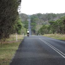
Armidale, Toms Gully, Puddledock loop
Un itinéraire vélo au départ de Armidale, Nouvelle-Galles du Sud, Australie.
Vue d'ensemble
À propos du circuit
Une belle sortie, un peu plus courte que la boucle complète de Guyra. Prends la Boorolong Rd vallonnée mais panoramique en sortant d'Armidale et tourne sur Toms Gully Rd. Cette portion est non goudronnée sur environ 7 à 8 km. Jette un œil à la gare bien entretenue de Black Mountain (pas de services sauf si quelqu'un occupe le bâtiment et a déverrouillé les toilettes). Si on fait cette boucle, on emporte un encas à manger à la gare, mais la station-service sur la grande route vend effectivement à manger. Après avoir traversé la route principale, tourne à gauche puis prends SpringMount Rd. Celle-ci aussi comporte une portion non goudronnée mais offre de beaux points de vue. En bifurquant sur Hoys Rd juste avant d'atteindre la grande route, tu peux éviter presque tout ce tronçon avant d'arriver en ville.
- -:--
- Durée
- 71,6 km
- Distance
- 607 m
- Montée
- 607 m
- Descente
- ---
- Vit. moyenne
- ---
- Altitude max.
Photos de l’itinéraire
Continuer avec Bikemap
Utilise, modifie ou télécharge cet itinéraire vélo
Tu veux parcourir Armidale, Toms Gully, Puddledock loop ou l’adapter à ton propre voyage ? Voici ce que tu peux faire avec cet itinéraire Bikemap :
Fonctionnalités gratuites
- Enregistre cet itinéraire comme favori ou dans une collection
- Copie et planifie ta propre version de cet itinéraire
- Synchronise ton itinéraire avec Garmin ou Wahoo
Fonctionnalités Premium
Essai gratuit de 3 jours, ou paiement unique. En savoir plus sur Bikemap Premium.
- Navigue sur cet itinéraire sur iOS et Android
- Exporter un fichier GPX / KML de cet itinéraire
- Crée ton impression personnalisée (essaie-la gratuitement)
- Télécharge cet itinéraire pour la navigation hors ligne
Découvre plus de fonctionnalités Premium.
Obtiens Bikemap PremiumDe notre communauté
Armidale : Autres itinéraires populaires qui commencent ici
 Armidale Tourist Information Centre to Dangars Gorge return
- Distance
- 47 km
- Montée
- 355 m
- Descente
- 353 m
- Emplacement
- Armidale, Nouvelle-Galles du Sud, Australie
 Avoiding the Waterfall Way from Armidale
- Distance
- 92,5 km
- Montée
- 708 m
- Descente
- 708 m
- Emplacement
- Armidale, Nouvelle-Galles du Sud, Australie
 Kelly's plains circuit
- Distance
- 19,5 km
- Montée
- 179 m
- Descente
- 179 m
- Emplacement
- Armidale, Nouvelle-Galles du Sud, Australie
 Armidale to Uralla via Arding
- Distance
- 54,5 km
- Montée
- 405 m
- Descente
- 396 m
- Emplacement
- Armidale, Nouvelle-Galles du Sud, Australie
 Armidale to Point Lookout loop
- Distance
- 226,3 km
- Montée
- 4 225 m
- Descente
- 4 225 m
- Emplacement
- Armidale, Nouvelle-Galles du Sud, Australie
 New England Cycle Trail South
- Distance
- 353,4 km
- Montée
- 999 m
- Descente
- 1 577 m
- Emplacement
- Armidale, Nouvelle-Galles du Sud, Australie
 Flat White
- Distance
- 19,5 km
- Montée
- 203 m
- Descente
- 201 m
- Emplacement
- Armidale, Nouvelle-Galles du Sud, Australie
 Armidale, Toms Gully, Puddledock loop
- Distance
- 71,6 km
- Montée
- 607 m
- Descente
- 607 m
- Emplacement
- Armidale, Nouvelle-Galles du Sud, Australie
Ouvre-la dans l’app


