

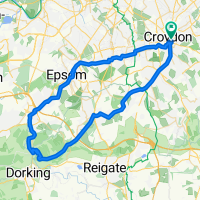
South Croydon, Banstead, Box Hill, Reigate Loop
Un itinéraire vélo au départ de South Croydon, Angleterre, Royaume-Uni.
Vue d'ensemble
À propos du circuit
Une version légèrement plus longue de mon parcours habituel vers Box Hill.
Là où Garratts Lane rejoint la A217, je traverse normalement la route au feu. Tu peux soit suivre le trajet indiqué sur la carte via The Drive puis prendre la première à gauche, traverser Nork Park et faire gauche-droite à la sortie, soit descendre la petite rue résidentielle le long de la A217 et tourner à droite aux feux.
Lors de la montée de Markedge Lane sur le chemin du retour, tu passes devant Fannys Farm Shop, qui est toujours un bon endroit pour recharger les batteries.
- -:--
- Durée
- 62,8 km
- Distance
- 509 m
- Montée
- 509 m
- Descente
- ---
- Vit. moyenne
- ---
- Altitude max.
Qualité de l’itinéraire
Types de voies et surfaces le long de l’itinéraire
Types de routes
Route tranquille
23,9 km
(38 %)
Route
12,6 km
(20 %)
surfaces
Pavé
32,6 km
(52 %)
Asphalte
32,6 km
(52 %)
Indéfini
30,1 km
(48 %)
Continuer avec Bikemap
Utilise, modifie ou télécharge cet itinéraire vélo
Tu veux parcourir South Croydon, Banstead, Box Hill, Reigate Loop ou l’adapter à ton propre voyage ? Voici ce que tu peux faire avec cet itinéraire Bikemap :
Fonctionnalités gratuites
- Enregistre cet itinéraire comme favori ou dans une collection
- Copie et planifie ta propre version de cet itinéraire
- Synchronise ton itinéraire avec Garmin ou Wahoo
Fonctionnalités Premium
Essai gratuit de 3 jours, ou paiement unique. En savoir plus sur Bikemap Premium.
- Navigue sur cet itinéraire sur iOS et Android
- Exporter un fichier GPX / KML de cet itinéraire
- Crée ton impression personnalisée (essaie-la gratuitement)
- Télécharge cet itinéraire pour la navigation hors ligne
Découvre plus de fonctionnalités Premium.
Obtiens Bikemap PremiumDe notre communauté
South Croydon : Autres itinéraires populaires qui commencent ici
 Croydon to Greenwich ( Via Cycle Route 21)
- Distance
- 17,8 km
- Montée
- 4 m
- Descente
- 83 m
- Emplacement
- South Croydon, Angleterre, Royaume-Uni
 680 Purley Way, Croydon to Brighton Railway Station, Queen's Road, Brighton
- Distance
- 70 km
- Montée
- 359 m
- Descente
- 380 m
- Emplacement
- South Croydon, Angleterre, Royaume-Uni
 l bright
- Distance
- 18,3 km
- Montée
- 131 m
- Descente
- 98 m
- Emplacement
- South Croydon, Angleterre, Royaume-Uni
 South Croydon, Botley Godstone, Merstham, Chipstead Loop
- Distance
- 54,4 km
- Montée
- 526 m
- Descente
- 526 m
- Emplacement
- South Croydon, Angleterre, Royaume-Uni
 Purley Way 403A to Ship Street
- Distance
- 57,7 km
- Montée
- 455 m
- Descente
- 373 m
- Emplacement
- South Croydon, Angleterre, Royaume-Uni
 Croydon - Box Hill
- Distance
- 54 km
- Montée
- 293 m
- Descente
- 292 m
- Emplacement
- South Croydon, Angleterre, Royaume-Uni
 London-Crydon nach Dover
- Distance
- 140,6 km
- Montée
- 1 047 m
- Descente
- 1 038 m
- Emplacement
- South Croydon, Angleterre, Royaume-Uni
 Croydon, Layhams Road, Botley, Redhill, Dorking, Box HIll loop
- Distance
- 79,1 km
- Montée
- 580 m
- Descente
- 580 m
- Emplacement
- South Croydon, Angleterre, Royaume-Uni
Ouvre-la dans l’app