

Richmond-Montgomery Century
Un itinéraire vélo au départ de Williston, Vermont, United States of America.
Vue d'ensemble
À propos du circuit
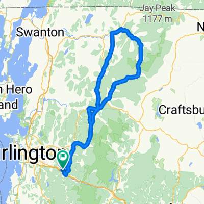
This 100-mile ride travels Pleasant Valley Rd, then climbs Rte 109 and loops through Montgomery to North Enosburg, returning on N. Enosburg Rd and Rte 108, then Lower Pleasant Valley Rd before backtracking largely over the same route. Hilly, but no monster climbs. There's several miles of gradual climbing up Rte 109 and a steeper, but not terribly long climb at the northern end of N. Enosburg Rd. Just a good, northern Vermont century, without any dirt.
- -:--
- Durée
- 162,5 km
- Distance
- 1 854 m
- Montée
- 1 756 m
- Descente
- ---
- Vit. moyenne
- 387 m
- Altitude max.

Qualité de l’itinéraire
Types de voies et surfaces le long de l’itinéraire
Types de routes
Route fréquentée
93,3 km
(57 %)
Route
59,1 km
(36 %)
surfaces
Pavé
153,7 km
(95 %)
Non pavé
7,3 km
(4 %)
Asphalte
153,6 km
(94 %)
Non pavé (non défini)
4 km
(2 %)
Continuer avec Bikemap
Utilise, modifie ou télécharge cet itinéraire vélo
Tu veux parcourir Richmond-Montgomery Century ou l’adapter à ton propre voyage ? Voici ce que tu peux faire avec cet itinéraire Bikemap :
Fonctionnalités gratuites
- Enregistre cet itinéraire comme favori ou dans une collection
- Copie et planifie ta propre version de cet itinéraire
- Divise-le en étapes pour créer un tour sur plusieurs jours
- Synchronise ton itinéraire avec Garmin ou Wahoo
Fonctionnalités Premium
Essai gratuit de 3 jours, ou paiement unique. En savoir plus sur Bikemap Premium.
- Navigue sur cet itinéraire sur iOS et Android
- Exporter un fichier GPX / KML de cet itinéraire
- Crée ton impression personnalisée (essaie-la gratuitement)
- Télécharge cet itinéraire pour la navigation hors ligne
Découvre plus de fonctionnalités Premium.
Obtiens Bikemap PremiumDe notre communauté
Williston : Autres itinéraires populaires qui commencent ici
 20110825 Williston to Burlington
- Distance
- 19,2 km
- Montée
- 125 m
- Descente
- 192 m
- Emplacement
- Williston, Vermont, United States of America
 Michael Lane 154, Williston to Bayley Hazen Road 643, Peacham
- Distance
- 95 km
- Montée
- 1 549 m
- Descente
- 1 302 m
- Emplacement
- Williston, Vermont, United States of America
 20110824 Around Williston
- Distance
- 17,1 km
- Montée
- 155 m
- Descente
- 124 m
- Emplacement
- Williston, Vermont, United States of America
 ARRB
ARRB- Distance
- 227,9 km
- Montée
- 3 420 m
- Descente
- 3 348 m
- Emplacement
- Williston, Vermont, United States of America
 Richmond/Hinesburg Route
- Distance
- 47,8 km
- Montée
- 478 m
- Descente
- 480 m
- Emplacement
- Williston, Vermont, United States of America
 25 M to Johnny Brook via Gov Chitt
- Distance
- 17,9 km
- Montée
- 173 m
- Descente
- 174 m
- Emplacement
- Williston, Vermont, United States of America
 Richmond-Montgomery Century
- Distance
- 162,5 km
- Montée
- 1 854 m
- Descente
- 1 756 m
- Emplacement
- Williston, Vermont, United States of America
 Richmond-Hinesburg 30
- Distance
- 51,7 km
- Montée
- 678 m
- Descente
- 678 m
- Emplacement
- Williston, Vermont, United States of America
Ouvre-la dans l’app