

Trasa C – kaňonem Oppedette do Manosque
Un itinéraire vélo au départ de Reillanne, Provence-Alpes-Côte d'Azur, France.
Vue d'ensemble
À propos du circuit
Nous partons de la rotonde dans le charmant village de Simiane-la-Rotonde et après un arrêt à l'abbaye, nous allons à Valsaites, en passant par l'un des canyons les plus abrupts de la Provence – le canyon d'Oppedette. Nous visiterons le village de Viens, construit sur un promontoire rocheux, puis l'ancienne église priorale Prieuré de Carluc. Depuis le village de Cereste, nous nous dirigerons lentement le long des pentes du grand Luberon vers Montfuron, où se dresse un moulin à vent bien conservé; à proximité se trouve la chapelle StElzeard. Ensuite, nous descendons vers Manosque, la ville de la cosmétique naturelle L'Occitanne, qui nous est déjà connue. Ici, en plus de la partie historique de la ville, nous examinerons également la ville depuis la hauteur de la tour du Mont d'Or sur l'une des collines près du centre.
- -:--
- Durée
- 53,4 km
- Distance
- 886 m
- Montée
- 1 226 m
- Descente
- ---
- Vit. moyenne
- ---
- Altitude max.

Qualité de l’itinéraire
Types de voies et surfaces le long de l’itinéraire
Types de routes
Route tranquille
22,4 km
(42 %)
Route
14,4 km
(27 %)
surfaces
Pavé
24 km
(45 %)
Non pavé
4,3 km
(8 %)
Asphalte
24 km
(45 %)
Gravier
3,2 km
(6 %)
Continuer avec Bikemap
Utilise, modifie ou télécharge cet itinéraire vélo
Tu veux parcourir Trasa C – kaňonem Oppedette do Manosque ou l’adapter à ton propre voyage ? Voici ce que tu peux faire avec cet itinéraire Bikemap :
Fonctionnalités gratuites
- Enregistre cet itinéraire comme favori ou dans une collection
- Copie et planifie ta propre version de cet itinéraire
- Synchronise ton itinéraire avec Garmin ou Wahoo
Fonctionnalités Premium
Essai gratuit de 3 jours, ou paiement unique. En savoir plus sur Bikemap Premium.
- Navigue sur cet itinéraire sur iOS et Android
- Exporter un fichier GPX / KML de cet itinéraire
- Crée ton impression personnalisée (essaie-la gratuitement)
- Télécharge cet itinéraire pour la navigation hors ligne
Découvre plus de fonctionnalités Premium.
Obtiens Bikemap PremiumDe notre communauté
Reillanne : Autres itinéraires populaires qui commencent ici
 Descente sur toulon
- Distance
- 170,7 km
- Montée
- 1 173 m
- Descente
- 1 779 m
- Emplacement
- Reillanne, Provence-Alpes-Côte d'Azur, France
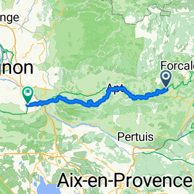
 Simiane-La-Rotonde - Rustrel - Oppedete - Manosque
- Distance
- 73,3 km
- Montée
- 1 009 m
- Descente
- 1 312 m
- Emplacement
- Reillanne, Provence-Alpes-Côte d'Azur, France
 De La Place 63, Vachères à Place Pierre Puget 79, La Londe-les-Maures
- Distance
- 140,4 km
- Montée
- 967 m
- Descente
- 1 836 m
- Emplacement
- Reillanne, Provence-Alpes-Côte d'Azur, France
 Trasa C – kaňonem Oppedette do Manosque
- Distance
- 53,4 km
- Montée
- 886 m
- Descente
- 1 226 m
- Emplacement
- Reillanne, Provence-Alpes-Côte d'Azur, France
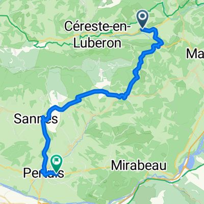 20250701 Reillanne nach Pertuis
- Distance
- 41 km
- Montée
- 459 m
- Descente
- 629 m
- Emplacement
- Reillanne, Provence-Alpes-Côte d'Azur, France
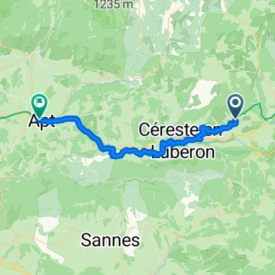 Reillanne - Apt
- Distance
- 31,5 km
- Montée
- 277 m
- Descente
- 590 m
- Emplacement
- Reillanne, Provence-Alpes-Côte d'Azur, France
 Reillanne - Mollégès
- Distance
- 85,1 km
- Montée
- 1 187 m
- Descente
- 1 685 m
- Emplacement
- Reillanne, Provence-Alpes-Côte d'Azur, France
 Dia 4 - Gite de Chaloux a Domain Saint Victor
- Distance
- 52,8 km
- Montée
- 701 m
- Descente
- 997 m
- Emplacement
- Reillanne, Provence-Alpes-Côte d'Azur, France
Ouvre-la dans l’app