

Lindenberg mit Herlisberg
Un itinéraire vélo au départ de Veltheim, Canton of Aargau, Switzerland.
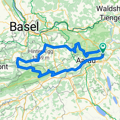
Vue d'ensemble
À propos du circuit
START : - H'bank
- Lenzburg - Muri - über Lindenberg nach Hitzkirch - Hochdorf - Stäfligen - Herlisberg - Beromünster - Reinach - Beinwil am See - Seon - Lenzburg ZIEL: - H'bank Max. Steigung: 10% Durchschn. Steigung: 5%- -:--
- Durée
- 86,1 km
- Distance
- 901 m
- Montée
- 901 m
- Descente
- ---
- Vit. moyenne
- ---
- Altitude max.

Qualité de l’itinéraire
Types de voies et surfaces le long de l’itinéraire
Types de routes
Route fréquentée
36,5 km
(42 %)
Route
25,7 km
(30 %)
surfaces
Pavé
34 km
(40 %)
Non pavé
2,7 km
(3 %)
Asphalte
32,9 km
(38 %)
Gravier
2,3 km
(3 %)
Continuer avec Bikemap
Utilise, modifie ou télécharge cet itinéraire vélo
Tu veux parcourir Lindenberg mit Herlisberg ou l’adapter à ton propre voyage ? Voici ce que tu peux faire avec cet itinéraire Bikemap :
Fonctionnalités gratuites
- Enregistre cet itinéraire comme favori ou dans une collection
- Copie et planifie ta propre version de cet itinéraire
- Divise-le en étapes pour créer un tour sur plusieurs jours
- Synchronise ton itinéraire avec Garmin ou Wahoo
Fonctionnalités Premium
Essai gratuit de 3 jours, ou paiement unique. En savoir plus sur Bikemap Premium.
- Navigue sur cet itinéraire sur iOS et Android
- Exporter un fichier GPX / KML de cet itinéraire
- Crée ton impression personnalisée (essaie-la gratuitement)
- Télécharge cet itinéraire pour la navigation hors ligne
Découvre plus de fonctionnalités Premium.
Obtiens Bikemap PremiumDe notre communauté
Veltheim : Autres itinéraires populaires qui commencent ici
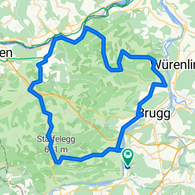
 Staffelegg - Benkerjoch - Saalhöhe - Kaistenberg - Bürersteig - Grünegg - Bözberg - Staffelegg
- Distance
- 132,3 km
- Montée
- 1 913 m
- Descente
- 1 923 m
- Emplacement
- Veltheim, Canton of Aargau, Switzerland
 Hallwilersee - Saalhöhe - Benkerjoch - Staffelegg
- Distance
- 99 km
- Montée
- 1 262 m
- Descente
- 1 255 m
- Emplacement
- Veltheim, Canton of Aargau, Switzerland
 Lindenberg mit Herlisberg
- Distance
- 86,1 km
- Montée
- 901 m
- Descente
- 901 m
- Emplacement
- Veltheim, Canton of Aargau, Switzerland
 Staffelegg - Benkerjoch - Saalhöhe - Bözberg - Geissberg - Staffelegg
- Distance
- 129,5 km
- Montée
- 1 779 m
- Descente
- 1 779 m
- Emplacement
- Veltheim, Canton of Aargau, Switzerland
 Niesenberg mit Hallwilersee
- Distance
- 59,1 km
- Montée
- 463 m
- Descente
- 463 m
- Emplacement
- Veltheim, Canton of Aargau, Switzerland
 Passwang über Langenbruck mit Benkerjoch und Staffelegg
- Distance
- 152,6 km
- Montée
- 1 835 m
- Descente
- 1 832 m
- Emplacement
- Veltheim, Canton of Aargau, Switzerland
 Weissenstein (Nordrampe)
- Distance
- 143 km
- Montée
- 1 231 m
- Descente
- 1 229 m
- Emplacement
- Veltheim, Canton of Aargau, Switzerland
 Staffelegg - Kaisten - Laufenburg - Villigen
- Distance
- 68,8 km
- Montée
- 885 m
- Descente
- 885 m
- Emplacement
- Veltheim, Canton of Aargau, Switzerland
Ouvre-la dans l’app